Search
found 10 results
Images for volcanic rock; more images...

Vulnerability to Seismic Hazards in Coastal and Riverside Communities, map…
Images, UC QuakeStudies
A map of the coastlines changes around Christchurch 6900 BC till present.
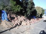
Digital Photograph: Earthquake Damage to Retaining Wall, corner of Oxford …
Images, Canterbury Museum
One landscape colour digital photograph taken on 15 June 2011 showing earthquake damage to the retaining wall on the northeast corner of Oxford and Exeter Streets. The wall was constructed from unreinforced blocks of local red volcanic rock held together with mortar. Retaining walls in Lyttelton were built of unreinforced soft volcanic stone in...
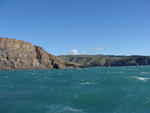
Digital Photograph: Godley Head, Lyttelton Harbour
Images, Canterbury Museum
One landscape colour digital photograph taken on 26 May 2013 off Godley Head looking north to Boulder Bay and Taylors Mistake. Rock which fell from the cliffs is heaped at the waters edge. Volcanic banding is visible in the face of the cliffs. There were several major rock falls along the coastal cliffs near Christchurch and Lyttelton Harbour....
Digital Photograph: Godley Head Lighthouse
Images, Canterbury Museum
One landscape colour digital photograph taken on 26 May 2013 showing the Godley Head Lighthouse and cliffs. Taken from the entrance to Lyttelton Harbour looking north. The Godley Head Lighthouse (K4286) was discontinued on 6 July 2012. Volcanic banding is visible in the face of the cliffs. There were several major rock falls along the coastal ...
Digital Photograph: Godley Head
Images, Canterbury Museum
One landscape colour digital photograph taken on 26 May 2013 off Godley Head looking west towards the face of the cliffs. Rock which fell from the cliffs is heaped at the waters edge. Some of the buildings from the coastal defence battery are visible on top of the cliff. Volcanic banding is visible in the face of the cliffs. There were severa...
Digital Photograph: Retaining Wall, Sumner Road, Lyttelton
Images, Canterbury Museum
One landscape colour digital photograph taken on 27 May 2013 of a retaining wall in Sumner Road which was replaced due to earthquake damage. The original wall was created using red volcanic rock. Many walls like this were built using the Hard Labour Gang from the Lyttelton Gaol. The replacement wall has a small section of stone installed to sho...
Simulation of systematic site amplification effects observed at Heathcote …
Research papers, University of Canterbury Library
he strong motion station at Heathcote Valley School (HVSC) recorded unusually high peak ground accelerations (2.21g vertical and 1.41g horizontal) during the February 2011 Christchurch earthquake. Ground motions recorded at HVSC in numerous other events also exhibited consistently higher intensities compared with nearby strong motion stations. We investigated the underlying causes of such high intensity ground motions at HVSC by means of 2D dynamic finite element analyses, using recorded ground motions during the 2010-2011 Canterbury earthquake sequence. The model takes advantage of a LiDAR-based digital elevation model (DEM) to account for the surface topography, while the geometry and dynamic properties of the surficial soils are characterized by seismic cone penetration tests (sCPT) and Multi-Channel Analyses of Surface Waves (MASW). Comparisons of simulated and recorded ground motions suggests that our model performs well for distant events, while for near-field events, ground motions recorded at the adopted reference station at Lyttelton Port are not reasonable input motions for the simulation. The simulations suggest that Rayleigh waves generated at the inclined interface of the surficial colluvium and underlying volcanic rock strongly affect the ground motions recorded at HVSC, in particular, being the dominant contributor to the recorded vertical motions.
NZ-specific pseudo-spectral acceleration ground motion prediction equation…
Research papers, University of Canterbury Library
Research Report No.2010-03 Ground motion prediction equations (GMPEs) for geometric-mean pseudo-spectral acceleration amplitudes from New Zealand (NZ) earthquakes are developed. A database of 2437 three-component ground motion records is developed by applying stringent quality criteria to the historically recorded events in NZ. Despite the large number of records, the database is deficient in empirical records from large magnitude events recorded at close distances to the fault rupture plane. As a result, the basis for the NZ-specific GMPE development is to examine the applicability of foreign GMPEs for similar tectonic regions and then modify the most applicable GMPEs based on both theoretical and statistically significant empirically-driven arguments. For active shallow crustal events, five different GMPEs are considered. It was found that the McVerry et al. (2006) model, which is the current model upon which seismic design guidelines and site-specific seismic hazard analyses in NZ are based, provided the worst fit to the NZ database, and that the Chiou et al. (2010) (C10) modification of the Chiou and Youngs (2008) model was the most applicable. Discrepancies between the C10 model and the NZ database that were empirically identified and theoretically justified were used to modify the C10 model for: (i) small magnitude scaling; (ii) scaling of short period ground motion from normal faulting events in volcanic crust; (iii) scaling of ground motions on very hard rock sites; (iv) anelastic attenuation in the NZ crust; and (v) consideration of the increased anelastic attenuation in the Taupo Volcanic Zone (TVZ). For subduction slab events, initially three models were considered. It was found that all of the models had some significant biases with respect to applicability for NZ. The Zhao et al. (2006) (Z06) model was selected because of the rigorous database upon which it was developed and modified by: (i) NZ-specific scaling at small magnitudes; (ii) path scaling at large distances; (iii) consideration of the increased TVZ attenuation; and (iv) revision of the standard deviation model. Based on these modifications the developed model showed no bias of the inter- and intra-event residuals as a function of various predictor variables. The standard deviation of the residuals using the revised standard deviation model also indicated that the model has an adequate precision. Three GMPEs were considered for subduction interface events. The Zhao et al. (2006) (Z06) model was the best performing model with only bias exhibited in the site response model, and possible over-prediction of large magnitude events. The Z06 interface model was modified to account for site response and magnitude scaling using the same functional forms as those of the developed active shallow crustal and subduction slab models. The developed model showed no bias of the inter- and intra-event residuals as a function of various predictor variables. The developed GMPEs include specific features as evident in the NZ database; consistent scaling for parameters not well constrained by the NZ database; and pseudo-spectral amplitudes for vibration periods from 0.01 to 10 seconds. Hence, these models represent a significant advance in the state-of-the art for empirical ground motion prediction in NZ.
2D-Modelling of Earthquake-Induced Rockfall from Basaltic Ignimbrite Cliff…
Research papers, University of Canterbury Library
This thesis is concerned with modelling rockfall parameters associated with cliff collapse debris and the resultant “ramp” that formed following the high peak ground acceleration (PGA) events of 22 February 2011 and 13 June 2011. The Christchurch suburb of Redcliffs, located at the base of the Port Hills on the northern side of Banks Peninsula, New Zealand, is comprised of Miocene-age volcanics with valley-floor infilling marine sediments. The area is dominated by basaltic lava flows of the Mt Pleasant Formation, which is a suite of rocks forming part of the Lyttelton Volcanic Group that were erupted 11.0-10.0Ma. Fresh exposure enabled the identification of a basaltic ignimbrite unit at the study site overlying an orange tuff unit that forms a marker horizon spanning the length of the field area. Prior to this thesis, basaltic ignimbrite on Banks Peninsula has not been recorded, so descriptions and interpretations of this unit are the first presented. Mapping of the cliff face by remote observation, and analysis of hand samples collected from the base of the debris slopes, has identified a very strong (>200MPa), columnar-jointed, welded unit, and a very weak (<5MPa), massive, so-called brecciated unit that together represent the end-member components of the basaltic ignimbrite. Geochemical analysis shows the welded unit is picrite basalt, and the brecciated unit is hawaiite, making both clearly distinguishable from the underlying trachyandesite tuff. RocFall™ 4.0 was used to model future rockfalls at Redcliffs. RocFall™ is a two-dimensional (2D), hybrid, probabilistic modelling programme for which topographical profile data is used to generate slope profiles. GNS Science collected the data used for slope profile input in March 2011. An initial sensitivity analysis proved the Terrestrial Laser Scan (TLS)-derived slope to be too detailed to show any results when the slope roughness parameter was tested. A simplified slope profile enabled slope roughness to be varied, however the resulting model did not correlate with field observations as well. By using slope profile data from March 2011, modelled rockfall behaviour has been calibrated with observed rockfall runout at Redcliffs in the 13 June 2011 event to create a more accurate rockfall model. The rockfall model was developed on a single slope profile (Section E), with the chosen model then applied to four other section lines (A-D) to test the accuracy of the model, and to assess future rockfall runout across a wider area. Results from Section Lines A, B, and E correlate very well with field observations, with <=5% runout exceeding the modelled slope, and maximum bounce height at the toe of the slope <=1m. This is considered to lie within observed limits given the expectation that talus slopes will act as a ramp on which modelled rocks travel further downslope. Section Lines C and D produced higher runout percentage values than the other three section lines (23% and 85% exceeding the base of the slope, respectively). Section D also has a much higher maximum bounce height at the toe of the slope (~8.0m above the slope compared to <=1.0m for the other four sections). Results from modelling of all sections shows the significance of the ratio between total cliff height (H) and horizontal slope distance (x), and of maximum drop height to the top of the talus (H*) and horizontal slope distance (x). H/x can be applied to the horizontal to vertical ratio (H:V) as used commonly to identify potential slope instability. Using the maximum value from modelling at Redcliffs, the future runout limit can be identified by applying a 1.4H:1V ratio to the remainder of the cliff face. Additionally, the H*/x parameter shows that when H*/x >=0.6, the percentage of rock runout passing the toe of the slope will exceed 5%. When H*/x >=0.75, the maximum bounce height at the toe of the slope can be far greater than when H*/x is below this threshold. Both of these parameters can be easily obtained, and can contribute valuable guideline data to inform future land-use planning decisions. This thesis project has demonstrated the applicability of a 2D probabilistic-based model (RocFall™ 4.0) to evaluate rockfall runout on the talus slope (or ramp) at the base of ~35-70m high cliff with a basaltic ignimbrite source. Limitations of the modelling programme have been identified, in particular difficulties with adjusting modelled roughness of the slope profile and the inability to consider fragmentation. The runout profile using RocFall™ has been successfully calibrated against actual profiles and some anomalous results have been identified.
- 1