Search
found 36 results
Images for volcanic; more images...
Vulnerability to Seismic Hazards in Coastal and Riverside Communities, map…
Images, UC QuakeStudies
A map of the coastlines changes around Christchurch 6900 BC till present.
Digital Photograph: Earthquake Damage to Retaining Wall, corner of Oxford …
Images, Canterbury Museum
One landscape colour digital photograph taken on 15 June 2011 showing earthquake damage to the retaining wall on the northeast corner of Oxford and Exeter Streets. The wall was constructed from unreinforced blocks of local red volcanic rock held together with mortar. Retaining walls in Lyttelton were built of unreinforced soft volcanic stone in...
BeckerFraserPhotos March 2011 photograph 060
Images, UC QuakeStudies
A footpath on Sumner Road in Lyttelton. A low wall made from local volcanic stone has been demolished to the left.
EQ-IQ Earthquake Commission.
Other, National Library of New Zealand
Information on the Earthquake Commission and how to prepare for earthquakes and other natural disasters such as tsunami, landslips, volcanic eruptions and hydrothermal activity.
Diamond Jubilee Clock Tower
Images, UC QuakeStudies
The damaged clock tower on Victoria Street, wrapped and braced to prevent further damage. The photographer comments, "Diamond Jubilee Clock Tower in Christchurch. Its legs wrapped up for protection. Volcanic stone and limestone clock tower with ornate wrought iron work with coloured glass around part of the tower and four clock faces. Clock Tower built in this location to commemorate the Diamond Jubilee of Queen Victoria. Has two white marble plaques and one bronze plaque set on stone work above arches".
Ready or not? Legal preparedness for an Auckland volcanic field eruption.
Research papers, University of Canterbury Library
This thesis focuses on the role of legal preparedness for managing large-scale urban disasters in Aotearoa New Zealand. It uses the Auckland Volcanic Field as a case study to answer the question: ‘is New Zealand’s current legal framework prepared to respond to and recover from a large-scale urban disaster?’. The Auckland Volcanic Field was chosen as the main case study because a future eruption is a low likelihood, high-impact event that New Zealand is going to have to manage in the future. Case studies are a key feature of this thesis as both New Zealand based and overseas examples are used to explore the role of legal preparedness by identifying and investigating a range of legal issues that need to be addressed in advance of a future Auckland Volcanic Field eruption. Of particular interest is the impact of legal preparedness for the recovery phase. The New Zealand case studies include; Canterbury earthquake sequence 2010-2011, the Kaikōura earthquake 2016, the Auckland flooding 2018, and the North Island Severe Weather event 2023, which encompasses both the Auckland Anniversary weekend flooding and Cyclone Gabrielle. As New Zealand has not experienced a large-scale urban volcanic eruption, overseas examples are explored to provide insights into the legal issues that are volcano specific. The overseas volcanic case studies cover eruptions in Heimaey (Iceland), the Soufrière Hills (Montserrat and the Grenadines), La Soufrière (St Vincent) and Tungurahua (Ecuador). New Zealand’s past experiences highlight a trend for introducing post-event legal frameworks to manage recovery. Consequently, the current disaster management system is not prioritising legal preparedness and instead is choosing to rely on exceptional powers. Unsurprisingly, the introduction of new post-event recovery frameworks has repercussions. In New Zealand, new post-event legal frameworks are introduced swiftly under urgency, they contain broad unstructured decision-making powers, and are often flawed. As these exceptional new frameworks sit outside the ‘normal’ legal frameworks, they in effect create a parallel “shadow system”. Based on the evidence explored in this thesis it does not appear that Auckland’s current disaster management framework is prepared to deal with a large-scale urban event caused by an Auckland Volcanic Field eruption. Following this conclusion, it is the submission of this thesis that New Zealand’s current legal framework is not prepared to respond to and recover from a large-scale urban disaster. To become legally prepared, New Zealand needs to consider the legal tools required to manage large-scale urban disasters in advance. This will prevent the creation of a legal vacuum in the aftermath of disasters and the need for new recovery frameworks. Adopting a new attitude will require a change in approach towards legal preparedness which prioritises it, rather than sidelining it. This may also require changes within New Zealand’s disaster management system including the introduction of a formal monitoring mechanism, which will support and prioritise legal preparedness. This thesis has shown that not legally preparing for future disasters is a choice which carries significant consequences. None of these consequences are inevitable when managing large-scale disasters, however they are inevitable when frameworks are not legally prepared in advance. To not legally prepare, is to prepare to fail and thus create a disaster by choice.
Winter, Mark 1958- :Christchurch recovery package - cash cloud. 24 June 20…
Images, Alexander Turnbull Library
The cartoon shows Christchurch obscured by ash. Text reads 'Christchurch recovery package' and below are the words 'Cash cloud'. Context - Beginning on the 6th of June the Puyehue-Cordon Caulle volcano has been erupting for more than a week. Drifting ash clouds have been interupting flights. On Thursday 23 June Prime Minister John Key, Canterbury Earthquake Recovery Minister Gerry Brownlee and representatives from engineering consultants Tonkin & Taylor announced the first part of the Government's long-awaited land report that revealed the fate of up to 5000 quake-damaged homes. These homes were in the 'red zone'. But 10,500 owners in the orange zone were left in limbo, with their properties requiring further assessment. One of the options presented to residents in the red zone, ideal for people with replacement policies, was the government bought your land, and you dealt directly with your insurers about your house. However they got a shock when insurers told them they won't replace their homes, they'll only repair them, even though they're earmarked for certain demolition. Quantity: 1 digital cartoon(s).
BeckerFraserPhotos March 2011 photograph 061
Images, UC QuakeStudies
A footpath on Sumner Road in Lyttelton. A low wall made from local volcanic stone has been demolished to the right. The land beyond the footpath has been cordoned off. Below Lyttelton Harbour can be seen, with Mount Evans in the background.
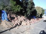
BeckerFraserPhotos March 2011 photograph 006
Images, UC QuakeStudies
A retaining wall on Sumner Road in Lyttelton that is made from local volcanic stone. A section of the wall has collapsed during the 22 February 2011 earthquake, and the bricks cleared away since. A road cone has been placed by the slip to warn drivers.
The Week in Review - week ending 17 June 2011
Audio, Radio New Zealand
A review of the week's news: Another earthquake in Christchurch, Prime Minister tight-lipped over what land will be abandoned because of repeated earthquake damage, volcanic ash cloud strands thousands of air passengers, tragic death of teen reignites debate over alcohol reform, problem gambling advocate objects to proposed casino expansion, wool the star at Fieldays and New Zealanders flock to the ballet.
Digital Photograph: Godley Head Lighthouse
Images, Canterbury Museum
One landscape colour digital photograph taken on 26 May 2013 showing the Godley Head Lighthouse and cliffs. Taken from the entrance to Lyttelton Harbour looking north. The Godley Head Lighthouse (K4286) was discontinued on 6 July 2012. Volcanic banding is visible in the face of the cliffs. There were several major rock falls along the coastal ...
Digital Photograph: Godley Head, Lyttelton Harbour
Images, Canterbury Museum
One landscape colour digital photograph taken on 26 May 2013 off Godley Head looking north to Boulder Bay and Taylors Mistake. Rock which fell from the cliffs is heaped at the waters edge. Volcanic banding is visible in the face of the cliffs. There were several major rock falls along the coastal cliffs near Christchurch and Lyttelton Harbour....
Sunset over a damaged city
Images, eqnz.chch.2010
Overlooking McCormacks bay out across the city with the Southern Alps as a backdrop. There is still a strong effect from the July 11, 2011 Volcanic erruption (Puyehue) in Chile. Ash made it over to New Zealand causing very strong colours at sunset. The colours have not been artificially changed and its not a mash up. The parts of the city (and...
Digital Photograph: Godley Head
Images, Canterbury Museum
One landscape colour digital photograph taken on 26 May 2013 off Godley Head looking west towards the face of the cliffs. Rock which fell from the cliffs is heaped at the waters edge. Some of the buildings from the coastal defence battery are visible on top of the cliff. Volcanic banding is visible in the face of the cliffs. There were severa...
Digital Photograph: Retaining Wall, Sumner Road, Lyttelton
Images, Canterbury Museum
One landscape colour digital photograph taken on 27 May 2013 of a retaining wall in Sumner Road which was replaced due to earthquake damage. The original wall was created using red volcanic rock. Many walls like this were built using the Hard Labour Gang from the Lyttelton Gaol. The replacement wall has a small section of stone installed to sho...
Nisbet, Alistair, 1958-: Daft things our forefathers did... 20 March 2011
Images, Alexander Turnbull Library
Text at top left reads 'Daft things our forefathers did The cartoon shows several nineteenth century gentlemen observing 'volcanic cones', a 'swamp' and 'faultlines underneath' and deciding to build a city. Context - Specifically the Christchurch earthquakes of 4 September 2010 and 22 February 2011 but generally the way many New Zealand cities are built on or near volcanoes, faultlines and swamps. Quantity: 1 digital cartoon(s).
Nisbet, Alistair, 1958-:[Mother Nature cooks up a menu of disasters] 14 Ja…
Images, Alexander Turnbull Library
A monster cook who represents 'Mother Nature' stirs several pots as storms swirl outside the window. She has a list of recipes that read 'earthquake entree, tornado twisties, blizzard Bolognese, volcanic mudcake, flood fondue, cyclone souffle'; she says 'Mmmm what shall I cook up next?' Context - the bad weather and the Christchurch earthquake that have afflicted the South Island recently. Published in The Sunday Star Times Quantity: 1 digital cartoon(s).
Digital storytelling in mediating caldera risk literacy in secondary schoo…
Research papers, University of Canterbury Library
Lake Taupō in New Zealand is associated with frequent unrest and small to moderate eruptions. It presents a high consequence risk scenario with immense potential for destruction to the community and the surrounding environment. Unrest associated with eruptions may also trigger earthquakes. While it is challenging to educate people about the hazards and risks associated with multiple eruptive scenarios, effective education of students can lead to better mitigation strategies and risk reduction. Digital resources with user-directed outcomes have been successfully used to teach action oriented skills relevant for communication during volcanic crisis [4]. However, the use of choose your own adventure strategies to enhance low probability risk literacy for Secondary school outreach has not been fully explored. To investigate how digital narrative storytelling can mediate caldera risk literacy, a module “The Kid who cried Supervolcano” will be introduced in two secondary school classrooms in Christchurch and Rotorua. The module highlights four learning objectives: (a) Super-volcanoes are beautiful but can be dangerous (b) earthquake (unrest) activity is normal for super-volcanoes (c) Small eruptions are possible from super-volcanoes and can be dangerous in our lifetimes (d) Super-eruptions are unlikely in our lifetimes. Students will create their digital narrative using the platform Elementari (www.elementari.io). The findings from this study will provide clear understanding of students’ understanding of risk perceptions of volcanic eruption scenarios and associated hazards and inform the design of educational resources geared towards caldera risk literacy.
THE LATEST DESIGN IN HOUSING FOR LIVING WITH NATURAL HAZARDS. 18 September…
Images, Alexander Turnbull Library
The cartoon shows a family standing proudly in front of their tent which has 'No leaks!', is 'Earthquake-proof!', and 'Affordable!' An 'Optional extra' is an 'inflatable base for tsunami-prone areas'. Text below reads 'Not suitable for volcanic areas. Refers to the problems that have been experienced in the last couple of decades with leaky homes because of slack building codes (which have now been tightened), refers also to the Canterbury earthquake of 4th September with its aftermath of rebuilding for greater earthquake proofing and lastly refers to the problem of people being unable to afford houses. Quantity: 1 digital cartoon(s).
Watershed management in New Zealand : status and research needs
Research Papers, Lincoln University
Nature has endowed New Zealand with unique geologic, climatic, and biotic conditions. Her volcanic cones and majestic Southern Alps and her verdant plains and rolling hills provide a landscape as rugged and beautiful as will be found anywhere. Her indigenous fauna and flora are often quite different from that of the rest of the world and consequently have been of widespread interest to biologists everywhere. Her geologic youth and structure and her island climate, in combination with the biological resources, have made a land which is ecologically on edge. These natural endowments along with the manner in which she has utilized her land, have given New Zealand some of the most spectacular and rapid erosion to be found. It is quite evident that geologic and climatic conditions combine to give unusually high rates of natural erosion. Present topographic features indicate the past occurrence of large-scale flooding as well. Prior to the arrival of the Maori, it is very likely that most of the land mass of New Zealand below present bush lines was covered with indigenous bush or forest. Forest fires of a catastrophic nature undoubtedly occurred as a result of lightning, and volcanic eruptions. The exposed soils left by these catastrophes contributed to natural deterioration. While vast areas of forest cover were destroyed, they probably were healed by nature with forest or with grass or herbaceous cover. Further, it is probable that large areas in the mountains were, as they are now, subject to landslides and slipping due to earthquakes and excessive local rainfall. Again, the healing process was probably rapid in most of such exposed areas.
Fine grained sediment clean-up in a modern urban environment
Research papers, University of Canterbury Library
Fine grained sediment deposition in urban environments during natural hazard events can impact critical infrastructure and properties (urban terrain) leading to reduced social and economic function and potentially adverse public health effects. Therefore, clean-up of the sediments is required to minimise impacts and restore social and economic functionality as soon as possible. The strategies employed to manage and coordinate the clean-up significantly influence the speed, cost and quality of the clean-up operation. Additionally, the physical properties of the fine grained sediment affects the clean-up, transport, storage and future usage of the sediment. The goals of the research are to assess the resources, time and cost required for fine grained sediment clean-up in an urban environment following a disaster and to determine how the geotechnical properties of sediment will affect urban clean-up strategies. The thesis focuses on the impact of fine grained sediment (<1 mm) deposition from three liquefaction events during the Canterbury earthquake sequence (2010-2011) on residential suburbs and transport networks in Christchurch. It also presents how geotechnical properties of the material may affect clean-up strategies and methods by presenting geotechnical analysis of tephra material from the North Island of New Zealand. Finally, lessons for disaster response planning and decision making for clean-up of sediment in urban environments are presented. A series of semi-structured interviews of key stakeholders supported by relevant academic literature and media reports were used to record the clean-up operation coordination and management and to make a preliminary qualification of the Christchurch liquefaction ejecta clean-up (costs breakdown, time, volume, resources, coordination, planning and priorities). Further analysis of the costs and resources involved for better accuracy was required and so the analysis of Christchurch City Council road management database (RAMM) was done. In order to make a transition from general fine sediment clean-up to specific types of fine disaster sediment clean-up, adequate information about the material properties is required as they will define how the material will be handled, transported and stored. Laboratory analysis of young volcanic tephra from the New Zealand’s North Island was performed to identify their geotechnical properties (density, granulometry, plasticity, composition and angle of repose). The major findings of this research were that emergency planning and the use of the coordinated incident management system (CIMS) system during the emergency were important to facilitate rapid clean-up tasking, management of resources and ultimately recovery from widespread and voluminous liquefaction ejecta deposition in eastern Christchurch. A total estimated cost of approximately $NZ 40 million was calculated for the Christchurch City clean-up following the 2010-2011 Canterbury earthquake sequence with a partial cost of $NZ 12 million for the Southern part of the city, where up to 33% (418 km) of the road network was impacted by liquefaction ejecta and required clearing of the material following the 22 February 2011 earthquake. Over 500,000 tonnes of ejecta has been stockpiled at Burwood landfill for all three liquefaction inducing earthquake events. The average cost per kilometre for the event clean-up was $NZ 5,500/km (4 September 2010), $NZ 11,650/km (22 February 2011) and $NZ 11,185/km (13 June 2011). The duration of clean-up time of residential properties and the road network was approximately two to three months for each of the three liquefaction ejecta events; despite events volumes and spatial distribution of ejecta. Interviews and quantitative analysis of RAMM data revealed that the experience and knowledge gained from the Darfield earthquake (4 September 2010) clean-up increased the efficiency of the following Christchurch earthquake induced liquefaction ejecta clean-up events. Density, particle size, particle shape, clay content and moisture content, are the important geotechnical properties that need to be considered when planning for a clean-up method that incorporates collection, transport and disposal or storage. The geotechnical properties for the tephra samples were analysed to increase preparedness and reaction response of potentially affected North Island cities from possible product from the active volcanoes in their region. The geotechnical results from this study show that volcanic tephra could be used in road or construction material but the properties would have to be further investigated for a New Zealand context. Using fresh volcanic material in road, building or flood control construction requires good understanding of the material properties and precaution during design and construction to extra care, but if well planned, it can be economically beneficial.
Broadband ground motion simulation of the 2010-2011 Canterbury earthquake …
Research papers, University of Canterbury Library
In this paper, we perform hybrid broadband (0-10 Hz) ground motion simulations for the ten most significant events (Mw 4.7-7.1) in the 2010-2011 Canterbury earthquake sequence. Taking advantage of having repeated recordings at same stations, we validate our simulations using both recordings and an empirically-developed ground motion prediction equation (GMPE). The simulation clearly captures the sedimentary basin amplification and the rupture directivity effects. Quantitative comparisons of the simulations with both recordings and the GMPE, as well as analyses of the total residuals (indicating model bias) show that simulations perform better than the empirical GMPE, especially for long period. To scrutinize the ground motion variability, we partitioned the total residuals into different components. The total residual appears to be unbiased, and the use of a 3D velocity structure reduces the long period systematic bias particularly for stations located close to the Banks Peninsula volcanic area.
Geologic and anthropogenic influences on rockfall and liquefaction in the …
Research papers, University of Canterbury Library
Geologic phenomena produced by earthquake shaking, including rockfalls and liquefaction features, provide important information on the intensity and spatiotemporal distribution of earthquake ground motions. The study of rockfall and liquefaction features produced in contemporary well- instrumented earthquakes increases our knowledge of how natural and anthropogenic environments respond to earthquakes and improves our ability to deduce seismologic information from analogous pre-contemporary (paleo-) geologic features. The study of contemporary and paleo- rockfall and liquefaction features enables improved forecasting of environmental responses to future earthquakes. In this thesis I utilize a combination of field and imagery-based mapping, trenching, stratigraphy, and numerical dating techniques to understand the nature and timing of rockfalls (and hillslope sedimentation) and liquefaction in the eastern South Island of New Zealand, and to examine the influence that anthropogenic activity has had on the geologic expressions of earthquake phenomena. At Rapaki (Banks Peninsula, NZ), field and imagery-based mapping, statistical analysis and numerical modeling was conducted on rockfall boulders triggered by the fatal 2011 Christchurch earthquakes (n=285) and compared with newly identified prehistoric (Holocene and Pleistocene) boulders (n=1049) deposited on the same hillslope. A significant population of modern boulders (n=26) travelled farther downslope (>150 m) than their most-travelled prehistoric counterparts, causing extensive damage to residential dwellings at the foot of the hillslope. Replication of prehistoric boulder distributions using 3-dimensional rigid body numerical models requires the application of a drag-coefficient, attributed to moderate to dense slope vegetation, to account for their spatial distribution. Radiocarbon dating provides evidence for 17th to early 20th century deforestation at the study site during Polynesian and European colonization and after emplacement of prehistoric rockfalls. Anthropocene deforestation enabled modern rockfalls to exceed the limits of their prehistoric predecessors, highlighting a shift in the geologic expression of rockfalls due to anthropogenic activity. Optical and radiocarbon dating of loessic hillslope sediments in New Zealand’s South Island is used to constrain the timing of prehistoric rockfalls and associated seismic events, and quantify spatial and temporal patterns of hillslope sedimentation including responses to seismic and anthropogenic forcing. Luminescence ages from loessic sediments constrain timing of boulder emplacement to between ~3.0 and ~12.5 ka, well before the arrival of Polynesians (ca AD 1280) and Europeans (ca AD 1800) in New Zealand, and suggest loess accumulation was continuing at the study site until 12-13 ka. Large (>5 m3) prehistoric rockfall boulders preserve an important record of Holocene hillslope sedimentation by creating local traps for sediment aggradation and upbuilding soil formation. Sediment accumulation rates increased considerably (>~10 factor increase) following human arrival and associated anthropogenic burning of hillslope vegetation. New numerical ages are presented to place the evolution of loess-mantled hillslopes in New Zealand’s South Island into a longer temporal framework and highlight the roles of earthquakes and humans on hillslope surface process. Extensive field mapping and characterization for 1733 individual prehistoric rockfall boulders was conducted at Rapaki and another Banks Peninsula site, Purau, to understand their origin, frequency, and spatial and volumetric distributions. Boulder characteristics and distributions were compared to 421 boulders deposited at the same sites during the 2010-2011 Canterbury earthquake sequence. Prehistoric boulders at Rapaki and Purau are comprised of two dominant lithofacies types: volcanic breccia and massive (coherent) lava basalt. Volcanic breccia boulders are found in greatest abundance (64-73% of total mapped rockfall) and volume (~90-96% of total rockfall) at both locations and exclusively comprise the largest boulders with the longest runout distances that pose the greatest hazard to life and property. This study highlights the primary influence that volcanic lithofacies architecture has on rockfall hazard. The influence of anthropogenic modifications on the surface and subsurface geologic expression of contemporary liquefaction created during the 2010-2011 Canterbury earthquake sequence (CES) in eastern Christchurch is examined. Trench observations indicate that anthropogenic fill layer boundaries and the composition/texture of discretely placed fill layers play an important role in absorbing fluidized sand/silt and controlling the subsurface architecture of preserved liquefaction features. Surface liquefaction morphologies (i.e. sand blows and linear sand blow arrays) display alignment with existing utility lines and utility excavations (and perforated pipes) provided conduits for liquefaction ejecta during the CES. No evidence of pre-CES liquefaction was identified within the anthropogenic fill layers or underlying native sediment. Radiocarbon dating of charcoal within the youngest native sediment suggests liquefaction has not occurred at the study site for at least the past 750-800 years. The importance of systematically examining the impact of buried infrastructure on channelizing and influencing surface and subsurface liquefaction morphologies is demonstrated. This thesis highlights the importance of using a multi-technique approach for understanding prehistoric and contemporary earthquake phenomena and emphasizes the critical role that humans play in shaping the geologic record and Earth’s surface processes.
Simulation of systematic site amplification effects observed at Heathcote …
Research papers, University of Canterbury Library
he strong motion station at Heathcote Valley School (HVSC) recorded unusually high peak ground accelerations (2.21g vertical and 1.41g horizontal) during the February 2011 Christchurch earthquake. Ground motions recorded at HVSC in numerous other events also exhibited consistently higher intensities compared with nearby strong motion stations. We investigated the underlying causes of such high intensity ground motions at HVSC by means of 2D dynamic finite element analyses, using recorded ground motions during the 2010-2011 Canterbury earthquake sequence. The model takes advantage of a LiDAR-based digital elevation model (DEM) to account for the surface topography, while the geometry and dynamic properties of the surficial soils are characterized by seismic cone penetration tests (sCPT) and Multi-Channel Analyses of Surface Waves (MASW). Comparisons of simulated and recorded ground motions suggests that our model performs well for distant events, while for near-field events, ground motions recorded at the adopted reference station at Lyttelton Port are not reasonable input motions for the simulation. The simulations suggest that Rayleigh waves generated at the inclined interface of the surficial colluvium and underlying volcanic rock strongly affect the ground motions recorded at HVSC, in particular, being the dominant contributor to the recorded vertical motions.
Development of a 3D High-Resolution Velocity Model of the Canterbury, New …
Research papers, University of Canterbury Library
A 3D high-resolution model of the geologic structure and associated seismic velocities in the Canterbury, New Zealand region is developed utilising data from depthconverted seismic reflection lines, petroleum and water well logs, cone penetration tests, and implicitly guided by existing contour maps and geologic cross sections in data sparse subregions. The model, developed using geostatistical Kriging, explicitly represents the significant and regionally recognisable geologic surfaces that mark the boundaries between geologic units with distinct lithology and age. The model is examined in the form of both geologic surface elevation contour maps as well as vertical cross sections of shear wave velocity, with the most prominent features being the Banks Peninsula Miocene-Pliocene volcanic edifice, and the Pegasus and Rakaia late Mesozoic-Neogene sedimentary basins. The adequacy of the modelled geologic surfaces is assessed through a residual analysis of point constraints used in the Kriging and qualitative comparisons with previous geologic models of subsets of the region. Seismic velocities for the lithological units between the geologic surfaces have also been derived, thus providing the necessary information for a Canterbury velocity model (CantVM) for use in physics-based seismic wave propagation. The developed model also has application for the determination of depths to specified shear wave velocities for use in empirical ground motion modelling, which is explicitly discussed via an example.
InSAR Measurement of Vertical Land Motion at Urban and Rural New Zealand C…
Research papers, Victoria University of Wellington
<strong>Sea level rise is one consequence of Earth’s changing climate. Century-long tide gauge records show that global-mean sea-level rise reached 11-16 cm during the twentieth century at a mean rate of 1.2 mm/y. Today, the average rate of global-mean sea-level rise is higher at 3-4 mm/y and is expected to increase in the future. This represents a hazard to low elevation coastal zones worldwide. Yet, before global sea level projections can be used to characterise future coastal flood hazard at a local scale, the effects of tectonics (and other processes) that drive vertical land motion (VLM) must be considered. VLM is defined as the vertical velocity (uplift or subsidence) of the solid surface with respect to the centre of Earth. In this study, new VLM maps are generated over coastal strips in New Zealand, using Sentinel-1 InSAR and GNSS data.</strong>In New Zealand, measuring VLM using InSAR on naturally vegetated or agricultural land is difficult due to signal decorrelation. Along the rural Bay of Plenty coastal strip, I use a persistent-scatterer approach to generate a VLM map from both east-looking ascending and west-looking descending Sentinel-1 data between 2015-2021. Using time-series data over the same time period from a dense network of 20 GNSS sensors, I tie InSAR-derived line-of-sight velocity to the 2014 ITRF reference frame. I test two different methods for measuring VLM and compare the results against GNSS vertical velocity along the Bay of Plenty coast. Best results are achieved by first removing the interpolated horizontal GNSS velocity field from each of the InSAR datasets, before averaging the two VLM estimates. Measured VLM is between -3 and 3 mm/y, with negative values (subsidence) occurring within the low-lying Rangitāiki Plain and Ōpōtiki valley, and uplift across the elevated region west of Matatā.This thesis integrates geomorphological, geological, and historical levelling VLM records with modern satellite datasets to assess VLM across timescales ranging from 10 to 100,000 years at Matatā. Uplift rate has been variable through time, with average uplift over the last 300,000 years of 1 mm/y, 4.5 mm/y since 1720 years, 2 mm/y between 1950-1978, and 10 mm/y between 2004-2011. Previous modelling has shown that the best fit to the 2004-2011 rapid uplift rates is an inflating magmatic source at ~10 km depth beneath Matatā. To reconcile all data, I present a VLM model that consists of short-lived periods (7 years) of rapid uplift (10 mm/y), separated by longer periods (30 years) of lower background uplift (3 mm/y). The episodic nature of VLM at Matatā likely reflects short-lived periods of magmatic intrusion. Episodic VLM characterised by large rates of uplift (10 mm/y) has been seen at Taupō volcano, and other volcanic centers globally. It has been 12 years since the end of the last intrusion episode; this modelling suggest one may expect to observe increased uplift rates at Matatā in the coming decades. Densely populated urban coastal strips are most at risk from the effects of relative sea-level rise. At the same time, anthropogenic activities associated with urbanization, such as groundwater withdrawal, and land reclamation can lead to local land subsidence (LLS), further exacerbating the risk to urban infrastructure. LLS refers to subsidence relative to nearby land area assumed to be stable. In this thesis, I create the first high-resolution (10 m) maps of LLS at six urban coastal strips in New Zealand, with a combined length of 285 km, using Sentinel-1 InSAR data between 2018-2021. This analysis reveals 89% of urban coastal strips are subsiding at rates of -0.5 mm/y or greater, and 11% is subsiding at higher rates of -3.0 mm/y or greater. On average, subsidence is -0.6 to -2.9 mm/y higher at the coastal strip, compared to inland areas occupied by GNSS stations. This analysis also documents highly-localised hotspots of LLS, with subsidence rates of up to -15 mm/y. In Christchurch, rapid and localised subsidence (-8 mm/y) is observed within coastal suburbs New Brighton and Southshore. In most cities, the highest subsidence rates occur on land reclaimed in the early-late twentieth century, and in areas built on Holocene sediment. Time-series analysis of LLS at sites of reclaimed land shows both linear and non-linear rates of deformation over time periods of up to 6-8 years. This thesis highlights the variable exposure to relative sea-level rise of New Zealand coastal strips, and demonstrates that in many cases current rates of VLM should be expected to continue for the next few decades.
EVALUATING LIQUEFACTION POTENTIAL OF PUMICEOUS DEPOSITS THROUGH FIELD TEST…
Research papers, University of Canterbury Library
Pumice materials, which are problematic from an engineering viewpoint, are widespread in the central part of the North Island. Considering the impacts of the 2010-2011 Christchurch earthquakes, a clear understanding of their properties under earthquake loading is necessary. For example, the 1987 Edgecumbe earthquake showed evidence of localised liquefaction of sands of volcanic origin. To elucidate on this, research was undertaken to investigate whether existing empirical field-based methods to evaluate the liquefaction potential of sands, which were originally developed for hard-grained soils, are applicable to crushable pumice-rich deposits. For this purpose, two sites, one in Whakatane and another in Edgecumbe, were selected where the occurrence of liquefaction was reported following the Edgecumbe earthquake. Manifestations of soil liquefaction, such as sand boils and ejected materials, have been reported at both sites. Field tests, including cone penetration tests (CPT), shear-wave velocity profiling, and screw driving sounding (SDS) tests were performed at the sites. Then, considering estimated peak ground accelerations (PGAs) at the sites based on recorded motions and possible range of ground water table locations, liquefaction analysis was conducted at the sites using available empirical approaches. To clarify the results of the analysis, undisturbed soil samples were obtained at both sites to investigate the laboratory-derived cyclic resistance ratios and to compare with the field-estimated values. Research results clearly showed that these pumice-rich soils do not fit existing liquefaction assessment frameworks and alternate methods are necessary to characterise them.
Hydrogeological Investigation of Earthquake Related Springs in the Hillsbo…
Research papers, University of Canterbury Library
This thesis is concerned with springs that appeared in the Hillsborough, Christchurch during the 2010-2011 Canterbury Earthquake Sequence, and which have continued to discharge groundwater to the surface to the present time. Investigations have evolved, measurements of discharge at selected sites, limited chemical data on anions and isotope analysis. The springs are associated with earthquake generated fissures (extensional) and compression zones, mostly in loess-colluvium soils of the valley floor and lower slopes. Extensive peat swamps are present in the Hillsborough valley, with a groundwater table at ~1m below ground. The first appearance of the ‘new’ springs took place following the Mw 7.1 Darfield Earthquake on 4 September 2010, and discharges increased both in volume and extent of the Christchurch Mw 6.3 Earthquake of 22 February 2011. Five monitored sites show flow rates in the range of 4.2-14.4L/min, which have remained effectively constant for the duration of the study (2014-2015). Water chemistry analysis shows that the groundwater discharges are sourced primarily from volcanic bedrocks which underlies the valley at depths ≤50m below ground level. Isotope values confirm similarities with bedrock-sourced groundwater, and the short term (hours-days) influence of extreme rainfall events. Cyclone Lusi (2013-2014) affects were monitored and showed recovery of the bedrock derived water signature within 72 hours. Close to the mouth of the valley sediments interfinger with Waimakiriri River derived alluvium bearing a distinct and different isotope signature. Some mixing is evident at certain locations, but it is not clear if there is any influence from the Huntsbury reservoir which failed in the Port Hills Earthquake (22 February 2011) and stored groundwater from the Christchurch artesian aquifer system (Riccarton Gravel).
Urban Ensembles: An integrated approach to design in steep, urban landscap…
Research papers, Victoria University of Wellington
Urban Ensembles explores the way in which landscape and architecture can be employed together within the design of a steep, urban site. Lyttelton is a small port town on the border of Christchurch, settled in the foothills of a harbour formed by a major volcanic eruption. This rugged setting, with steeply sloping urban terrain, presents an interesting challenge when designing an urban development. The site was badly damaged in a series of earthquakes in 2010-2011, and many of the town’s oldest buildings, heritage structures dating back to the colonial settlement era, were destroyed. This has left a void in the heart of Lyttelton, and caused the loss of much of the tourism business that the town relies upon for its income. This thesis takes a methodological approach to the design of landscape architecture on such a challenging site. A range of techniques are explored, drawing from both landscape and architecture to explore the roles that each discipline plays in the design of urban spaces. The frequent imbalance between disciplines is addressed both through the literature review and design method, as this landscape architecture thesis draws on architectural design as a tool for generating spaces which fall somewhere in between the two ideals of interior and exterior. The final design proposal is an alternative rebuild plan for the central business area to the south of London St, and also addresses the relationships between that site and the surrounding context, both urban and environmental. The aim of this design is to create a series of interconnected spaces which have a strong relationship to the surrounding harbour setting, and also to facilitate development of the pedestrian spaces throughout the block and encouraging the development of activity at the street level, through the interface between buildings and landscape.
- 1
- »