Search
Images for school* NOT 2010; more images...
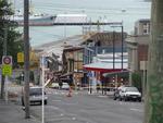
Digital Photograph: Earthquake damage in Oxford Street, Lyttelton
Images, Canterbury Museum
One landscape colour digital photograph taken on 25 February 2011 showing earthquake damage on western side of Oxford Street, Lyttelton Taken from the footpath looking downhill from Lyttelton Main School. The buildings visible (from the foreground) are: London Street Restaurant; Bells Pharmacy; Maritime House (McKay - ISS Limited, Shipping Ag...
Digital Photograph: Earthquake damage in Oxford Street, Lyttelton
Images, Canterbury Museum
One landscape colour digital photograph taken on 25 February 2011 showing earthquake damage on eastern side of Oxford Street, Lyttelton Taken from the footpath looking downhill from opposite Lyttelton Main School. The Buildings visible are the premises of Moda Fotografica (former Library and Council Chambers), a private residence (former Libra...
Digital Photograph: Temporary Drinking Water Tank on Oxford Street, Lyttel…
Images, Canterbury Museum
One landscape colour digital photograph taken on 25 February 2011 showing the temporary water tank installed on the grassy [local name for Lyttelton Main School Field] to provide drinking water for residents to collect when there was no town supply water. A temporary source of drinking water was needed following the 22 February 2011 earthquake...
Digital Photograph: Lyttelton Main School from the Gaol Steps, Lyttelton
Images, Canterbury Museum
One landscape colour digital photograph taken on 13 May 2011 showing Lyttelton Main School viewed from above near the top of the Gaol Steps between Oxford and St Davids Streets. The photograph is taken at an angle. Several subsequently demolished buildings are visible beyond the school including (from left to right) Lyttelton Police Station, th...
Digital Photograph: Gaol Steps and Lyttelton Main School, Oxford Street, L…
Images, Canterbury Museum
One landscape colour digital photograph taken on 13 May 2011 showing the damage to the Gaol Steps between Oxford and St Davids Streets and the upper playground of Lyttelton Main School. The Gaol Steps are a pedestrian link between Oxford and St Davids Streets. In October 2013 these steps were closed and barricaded with temporary fencing because...
- 1


