
Search
found 9 results
Images for port; more images...

Green Door: Port-a-Loo
Images, Canterbury Museum
One green plastic Port-A-Loo door with surround, lock and mirror on interior; Port-A-Loo logo on front. One of the most immediate challenges facing Christchurch residents following the 22 February 2011 earthquake was the restriction on using residential toilet facilities. The restrictions were implemented due to the extensive damage to sewerage...
Earthquake damage to the road from Cheviot to Port Robinson
Images, Alexander Turnbull Library
Earthquake damage to the road from Cheviot to Port Robinson, 1901. Taken by an unidentified photographer. This is a copy of a photograph from `The Weekly Press', Nov 27, 1901 Note on back of file print reads: "Fissures on the road from Cheviot to Port Robinson. There is a creek on the right side of the road, and below the fissure the road has fallen towards it.....and is 2 1/2' below its proper level. The fissures are 2 1/2' deep" (Probably the caption from `The Weekly Press') Quantity: 1 b&w original negative(s).
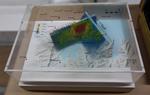
3-D Model: Port Hills Faults
Images, Canterbury Museum
One oblong perspex covered 3-D model of the fault plains that ruptured to cause the 22 February and 13 June 2011 earthquakes; top of the model also acts as a map overlay. This model provides a visual demonstration of the geological forces that caused the 22 February and 13 June 2011 earthquakes. These forces were so strong that parts of the Por...
Digital Photograph: Looking east from Norwich Quay, Lyttelton
Images, Canterbury Museum
One landscape colour digital photograph taken on 19 November 2011 looking east from Norwich Quay from approximately the base of Canterbury Street. Visible in the photograph are the partially deconstructed former Lyttelton Harbour Board Offices, the Holcim Cement Silos, the Oxford Street Railway Overbridge, Lyttelton Port of Christchurch's storag...
Digital Photograph: Helicopter with Monsoon Bucket washing away unstable r…
Images, Canterbury Museum
One portrait colour digital photograph taken on 25 February 2011 showing a helicopter using a monsoon bucket to wash away unstable rocks from cliffs behind the Lyttelton Container Terminal. One of the immediate priorities in Lyttelton was stabilising the transport routes both from Lyttelton to Christchurch and the port infrastructure so that go...
Digital Photograph: Earthquake Damage to Road on Norwich Quay, Lyttelton
Images, Canterbury Museum
One landscape colour digital photograph taken on 25 February 2011 showing earthquake damage to the road, footpath and retaining wall on Norwich Quay. The photograph is taken from below the intersection of Norwich Quay and Canterbury Street looking east along Norwich Quay. Unlike most areas of Christchurch, land damage on the Port Hills was due ...
Digital Photograph: Earthquake damage to the Lyttelton Timeball Station.
Images, Canterbury Museum
One landscape colour digital photograph taken on 16 June 2011 showing the eastern skyline of Lyttelton without the tower of the Timeball Station and Signal Mast. Part of the ground floor remains visible. The Holcim Cement Silos and Lyttelton Port of Christchurch log storage yard are visible in the foreground. Photograph taken from Oxford Street...
Digital Photograph: Elevated view of London Street, Lyttelton
Images, Canterbury Museum
One landscape colour digital photograph taken on 26 May 2013 of London Street, Lyttelton. The photograph was taken from St Davids Street looking west. The roofs of the portable buildings forming the temporary Lyttelton Police station are visible in the foreground. The Lyttelton Port Company offices and Tunnel Portal are prominent in the midgrou...
Digital Photograph: Demolition of the Dry Dock Pump House, Lyttelton
Images, Canterbury Museum
One landscape colour digital photograph taken on 22 March 2011 showing the demolition of the Dry Dock Pump House. Photograph taken from Brittan Terrace looking east over the Inner Harbour. Engineer The brick pump house for the Lyttelton Graving or Dry Dock was damaged in the 22 February 2011 Earthquake. Lyttelton Port of Christchurch decided to...
- 1