Search
found 5 results
Images for grave earthquake damage; more images...


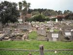
Digital Photograph: Earthquake Damage to Lyttelton Roman Catholic and Diss…
Images, Canterbury Museum
One landscape colour digital photograph taken on 30 June 2011 showing earthquake damage to graves in Lyttelton Roman Catholic and Dissenters (Public) Cemeteries in Reserve Terrace. Most of the headstones and grave surrounds in the photograph show damage. Looking east in the Dissenters (Public) section of the cemetery. The Lyttelton cemeteries a...
Digital Photograph: Earthquake Damage to Dry Dock Pump House, Lyttelton
Images, Canterbury Museum
One portrait colour digital photograph taken on 1 March 2011 showing earthquake damage to the Dry Dock Pump House. Photograph taken from Dampiers Bay Pile Moorings showing the eastern end of the building and the Cassion. Engineer The brick pump house for the Lyttelton Graving or Dry Dock was damaged in the 22 February 2011 earthquake. Lyttelton...
Digital Photograph: Earthquake Damage to Lyttelton Roman Catholic and Diss…
Images, Canterbury Museum
One landscape colour digital photograph taken on 30 June 2011 showing signs warning of the danger posed by unstable headstones in Lyttelton Roman Catholic and Dissenters (Public) Cemeteries in Reserve Terrace. Several toppled headstones and collapsed grave surrounds are visible in the photograph. Looking east from the main gate. The Lyttelton c...
Digital Photograph: Demolition of the Dry Dock Pump House, Lyttelton
Images, Canterbury Museum
One landscape colour digital photograph taken on 22 March 2011 showing the demolition of the Dry Dock Pump House. Photograph taken from Brittan Terrace looking east over the Inner Harbour. Engineer The brick pump house for the Lyttelton Graving or Dry Dock was damaged in the 22 February 2011 Earthquake. Lyttelton Port of Christchurch decided to...
Digital Photograph: Demolition of the Dry Dock Pump House, Lyttelton
Images, Canterbury Museum
One landscape colour digital photograph taken on 22 March 2011 showing the demolition of the Dry Dock Pump House. Photograph taken from Cyrus Williams Quay beside the Cattle Jetty showing the southern side of the building. Engineer The brick pump house for the Lyttelton Graving or Dry Dock was damaged in the 22 February 2011 Earthquake. Lyttelt...
- 1