Search
found 16 results
Images for building site; more images...


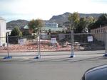
Digital Photograph: Site of Norton Buildings and Lyttelton Lounge, Oxford …
Images, Canterbury Museum
One landscape colour digital photograph taken on 12 April 2011 showing the site of the Norton Buildings and Lyttelton Lounge on Oxford Street. Architect The buildings on this site were severely damaged and demolished within days of the 22 February 2011 earthquake. The larger of the two properties in this photograph was the site of the 1913 Norto...
Digital Photograph: Site of the Volcano Restaurant, corner of London and C…
Images, Canterbury Museum
One landscape colour digital photograph taken on 8 June 2011 showing the site of the Volcano Restaurant on the corner of London and Canterbury Streets. The site is fenced with temporary fencing. The concrete of the floor of the building is visible. On the fence are two artworks, both made from woollen blankets. One, made from a cream blanket is ...
Digital Photograph: Corner of London and Canterbury Streets, Lyttelton
Images, Canterbury Museum
One landscape colour digital photograph taken on 19 November 2011 showing the site of the Albion Hotel/ Ground Delicatessen. After the demolition of the building the site was used for a Gap Filler initiative called the Lyttelton Petanque Club. The photograph shows the temporary furniture, landscaping and public Petanque court. The site formerl...
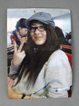
Colour Photograph: Unknown Female
Images, Canterbury Museum
One portrait colour photograph of an unknown female in an unknown location. In this colour photograph, an unknown young woman is shown in an unknown location. Left at the Canterbury Television (CTV) building site, it is one of many commemorative tributes left behind for the 115 people killed when the CTV building collapsed during the 22 Februar...
Digital Photograph: Lyttelton Sea Foods, Norwich Quay, Lyttelton
Images, Canterbury Museum
One landscape colour digital photograph taken on 19 November 2011 showing the temporary premises of Lyttelton Sea Foods in a relocatable building on Norwich Quay. The building is located on the site of the Lyttelton Hotel. Also visible in the photograph are (left to right) the side of Shadbolt House, the rear of the Pacifica Building which was t...
Colour Photograph: Six People in a Private Residence
Images, Canterbury Museum
One square colour photograph of six people in a private residence. In this colour photograph six unknown people are shown in a private residence. This photograph was left at the Canterbury Television (CTV) building site. It is one of many commemorative tributes left behind for the 115 people killed when the CTV building collapsed during the 22 ...
Digital Photograph: Temporary Premises of Lyttelton Bakery, corner of Norw…
Images, Canterbury Museum
One landscape colour digital photograph taken on 16 June 2011 showing the Lyttelton Bakery operating from a portable building on the Corner of Canterbury Street and Norwich Quay. This portable building has been placed on the site of the Royal Hotel. Also visible in the photograph are Shadbolt House and the rear of the buildings on the south side...
Digital Photograph: Earthquake Damage to Old Post Office Building on Norwi…
Images, Canterbury Museum
One portrait colour digital photograph taken on 25 February 2011 showing damage to the Old Post Office Building on the Corner of Norwich Quay and Oxford Street. Architect The archaeological investigation of the site of the old Lyttelton Post Office uncovered evidence of Maori settlement in the area including a midden, fire places and an adze. Th...
Digital Photograph: Earthquake Damage to Old Post Office Building on Norwi…
Images, Canterbury Museum
One landscape colour digital photograph taken on 27 April 2011 showing damage to the Old Post Office Building on the corner of Norwich Quay and Oxford Street. The old Telegraph office located beside the Old Post Office and the Timeball Station are also visible. Architect As Lyttelton's first main street, Norwich Quay was the site of many early g...
Digital Photograph: Temporary Artwork on the corner of London and Canterbu…
Images, Canterbury Museum
One landscape colour digital photograph taken on 19 November 2011 showing a temporary artwork on the site of the Albion Hotel/ Ground Delicatessen. After the demolition of the building the site was used for a Gap Filler initiative called the Lyttelton Petanque Club. The photograph shows a temporary artwork created from used bricks, probably from...
Digital Photograph: Earthquake Damage to Lyttelton Historical Museum, Glad…
Images, Canterbury Museum
One landscape colour digital photograph taken on 25 September 2011 showing the site of the Lyttelton Historical Museum on the corner of Gladstone Quay and Donald Street. The photograph shows the temporary fencing around the levelled site. The building visible at the rear is the former Municipal Stables on Donald Street. To the right of the phot...
Digital Photograph: Lyttelton Bakery, corner Norwich Quay and Canterbury S…
Images, Canterbury Museum
One landscape colour digital photograph taken on 19 November 2011 showing the temporary premises of Lyttelton Bakery in a relocatable building on Norwich Quay. The building is located on the site of the Royal Hotel. Also visible in the photograph are (left to right up Canterbury Street) Lyttelton Service Station, Samo, Lyttelton Telephone Exchan...
Colour Photograph: Possibly Miki Hayasaka
Images, Canterbury Museum
One portrait coloured head and shoulder photograph of an unknown female, possibly Miki Hayasaka, in a plastic cover. Item was left at the Canterbury Television (CTV) site following the building's collapse during the 22 February 2011 earthquake. This portrait appears to feature Miki Hayasaka, aged 37, from Japan. Miki was a student at King’s Edu...
Digital Photograph: Demolition of the Royal Hotel, corner of Norwich Quay …
Images, Canterbury Museum
One landscape colour digital photograph taken on 27 April 2011 showing the demolition of the Royal Hotel on the corner of Norwich Quay and Canterbury Street. The hotel building shown in this photograph was the third on the site since 1851. It was built in 1916 as a replacement for the first Royal Hotel. The Royal Hotel was established in 1870 a...
Digital Photograph: Corner of London and Oxford Streets, Lyttelton
Images, Canterbury Museum
One landscape colour digital photograph taken on 19 November 2011 showing the site of the old Lyttelton Library, Council Chambers and Magistrates' Court on the corner of Oxford Street and Sumner Road. At the time of the 22 February 2011 Earthquake the building was in private ownership and was the premises of Moda Fotografica and a private resid...
Photographs of central Christchurch after the 2010 and 2011 earthquakes
Images, Alexander Turnbull Library
Photographs of central Christchurch after the 2010-2012 earthquakes taken 25 February 2012 by Sean McMahon. Locations are chiefly Manchester, Saint Asaph, Cashel, Columbo and Lichfield Streets, and the Bridge of Remembrance. Images show fencing around areas closed to the public, damaged and collapsed commercial buildings, cleared sites, re-opened Cashel Street area with shops and a cafe. Source of title - Title supplied by Library Quantity: 34 digital photograph(s).
- 1