
Search
found 28 results
Images for building damage; more images...


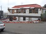
Digital Photograph: Earthquake Damage to Buildings and Car on Norwich Quay…
Images, Canterbury Museum
One portrait colour digital photograph taken on 25 February 2011 showing the damaged façade of a two storey shop on Norwich Quay. The brick wall has completely fallen off the top storey and crushed a car parked on the footpath outside. Damage to the Lyttelton Hotel is visible to the left of the photo. The design of many older commercial build...
Digital Photograph: Earthquake Damage to the Norton Buildings on Oxford St…
Images, Canterbury Museum
One landscape colour digital photograph taken on 25 February 2011 showing damage to the Norton Buildings on Oxford Street. The photograph shows part of the first floor of the building and the façade collapsed onto the ground floor and out onto the street. The photograph was taken from St Davids Street looking west. Also visible in the photogra...
Digital Photograph: Earthquake Damage to Lyttelton Times Building, Gladsto…
Images, Canterbury Museum
One landscape colour digital photograph taken on 3 March 2011 showing earthquake damage to the Lyttelton Times Building on Gladstone Quay. Also visible on the left of the photograph is the side of the adjoining British Hotel. Three years after the 2010-2011 earthquakes there are still many uncertainties about which buildings can or will be ret...
Digital Photograph: Earthquake damage on corner of Canterbury and London S…
Images, Canterbury Museum
One landscape colour digital photograph taken on 25 February 2011 showing earthquake damage to the premises of Ground Delicatessen on the corner of Canterbury and London Streets. The photograph shows the building's Canterbury Street façade. This building was initially built around 1864 as the Albion Hotel. After many modifications and changes ...
Digital Photograph: Earthquake damage to the old Vicarage, Lyttelton
Images, Canterbury Museum
One landscape colour digital photograph taken on 25 February 2011 showing the damage to the former Anglican Vicarage on Ripon Street Lyttelton. Taken from the footpath. Architect The sense of loss felt when confronted with the collapse or demolition of an historic building is compounded when that building is also a home. While the community sees...
Digital Photograph: Earthquake damage to St Joseph's Church, Winchester St…
Images, Canterbury Museum
One portrait colour digital photograph taken on 25 February 2011 showing earthquake damage to the Catholic Church of St Joseph the Worker in Winchester Street Lyttelton. Photograph shows the main doors and roof at southern end of church. Nineteenth century stone buildings are particularly vulnerable to earthquake damage as the individual compon...
Digital Photograph: Earthquake Damage to Old Post Office Building on Norwi…
Images, Canterbury Museum
One portrait colour digital photograph taken on 25 February 2011 showing damage to the Old Post Office Building on the Corner of Norwich Quay and Oxford Street. Architect The archaeological investigation of the site of the old Lyttelton Post Office uncovered evidence of Maori settlement in the area including a midden, fire places and an adze. Th...
Digital Photograph: Earthquake Damage to Old Post Office Building on Norwi…
Images, Canterbury Museum
One landscape colour digital photograph taken on 27 April 2011 showing damage to the Old Post Office Building on the corner of Norwich Quay and Oxford Street. The old Telegraph office located beside the Old Post Office and the Timeball Station are also visible. Architect As Lyttelton's first main street, Norwich Quay was the site of many early g...
Digital Photograph: Earthquake Damage to Dry Dock Pump House, Lyttelton
Images, Canterbury Museum
One portrait colour digital photograph taken on 1 March 2011 showing earthquake damage to the Dry Dock Pump House. Photograph taken from Dampiers Bay Pile Moorings showing the eastern end of the building and the Cassion. Engineer The brick pump house for the Lyttelton Graving or Dry Dock was damaged in the 22 February 2011 earthquake. Lyttelton...
Digital Photograph: Earthquake Damage to the Lodge of Unanimity No 3, at t…
Images, Canterbury Museum
One landscape colour digital photograph taken on 25 February 2011 showing damage to the Lodge of Unanimity No 3 at the intersection of St Davids Street and Sumner Road. Original BuildingAdditions The Lodge of Unanimity was established in Lyttelton in 1851. This building was designed in 1878 by Benjamin Woolfield Mountfort, who was a member of th...
Digital Photograph: Earthquake damage in Oxford Street, Lyttelton
Images, Canterbury Museum
One landscape colour digital photograph taken on 25 February 2011 showing earthquake damage on western side of Oxford Street, Lyttelton Taken from the footpath looking downhill from Lyttelton Main School. The buildings visible (from the foreground) are: London Street Restaurant; Bells Pharmacy; Maritime House (McKay - ISS Limited, Shipping Ag...
Digital Photograph: Earthquake damage in Oxford Street, Lyttelton
Images, Canterbury Museum
One landscape colour digital photograph taken on 25 February 2011 showing earthquake damage on eastern side of Oxford Street, Lyttelton Taken from the footpath looking downhill from opposite Lyttelton Main School. The Buildings visible are the premises of Moda Fotografica (former Library and Council Chambers), a private residence (former Libra...
Digital Photograph: Earthquake damage on Canterbury Street, Lyttelton
Images, Canterbury Museum
One landscape colour digital photograph taken on 25 February 2011 showing earthquake damage to houses on the western side of Canterbury Street between London and Winchester Streets. The photograph shows large sections of a brick firewall which have fallen onto the roof of the neighbouring house. The close proximity of buildings in Lyttelton led...
Digital Photograph: Site of Norton Buildings and Lyttelton Lounge, Oxford …
Images, Canterbury Museum
One landscape colour digital photograph taken on 12 April 2011 showing the site of the Norton Buildings and Lyttelton Lounge on Oxford Street. Architect The buildings on this site were severely damaged and demolished within days of the 22 February 2011 earthquake. The larger of the two properties in this photograph was the site of the 1913 Norto...
Digital Photograph: Earthquake damage on corner of Canterbury and London S…
Images, Canterbury Museum
One landscape colour digital photograph taken on 25 February 2011 showing earthquake damage to the corner of Canterbury and London Streets. The photograph is taken from Canterbury Street looking down hill. The buildings visible are The Volcano Restaurant, the Lyttelton Library, the Lyttelton Working Mens' Club (The Loons), and the Royal Hotel (o...
Digital Photograph: Earthquake Damage to Lyttelton Coffee Company, London …
Images, Canterbury Museum
One landscape colour digital photograph taken on 9 March 2011 showing earthquake damage to the Lyttelton Coffee Company Building on London Street. The photograph shows a fenced off section of the south side of London Street. Also visible in the photograph are the Lyttelton Four Square, and the gateway leading to the Wunderbar. Due to prior eart...
Digital Photograph: Earthquake Damage to Canterbury Hotel and shops. Oxfor…
Images, Canterbury Museum
One landscape colour digital photograph taken on 15 June 2011 showing earthquake damage to the former Canterbury Hotel and adjoining row of shops on Oxford Street. This photograph was taken on Oxford Street and shows the collapsed façade of the row of shops behind safety fencing, the interior of the building is exposed. Shadbolt House is visib...
Digital Photograph: Earthquake damage to St John's Church, Winchester Stre…
Images, Canterbury Museum
One landscape colour digital photograph taken on 15 June 2011 showing earthquake damage to the Presbyterian Church of St John in Winchester Street, Lyttelton. Photograph shows the collapsed roof and tower. The photograph is taken from the southern side of the church. Architect The destructive force of the 14 June 2011 earthquakes on buildings in...
Digital Photograph: Earthquake Damage to Canterbury Hotel and shops. Oxfor…
Images, Canterbury Museum
One landscape colour digital photograph taken on 15 June 2011 showing earthquake damage to the former Canterbury Hotel and adjoining row of shops on Oxford Street. This photograph was taken on Oxford Street and shows the collapsed façade of the row of shops behind safety fencing, the interior of the building is exposed. The design of many older...
Digital Photograph: Earthquake damage to the Empire Hotel, London Street, …
Images, Canterbury Museum
One landscape colour digital photograph taken on 12 April 2011 showing earthquake damage to the Empire Hotel on London Street. The photograph shows the façade of the hotel supported by the framework installed to brace the building after the 4 September 2010 earthquake. Also visible on the fencing in the foreground is the advertising placard for...
Digital Photograph: Former Convent of Our Lady of Mercy, Exeter Street, Ly…
Images, Canterbury Museum
One landscape colour digital photograph taken on 12 April 2011 showing earthquake damage to the former Convent of Our Lady of Mercy. St Mary's School, run by the Sisters of Mercy, was also housed in this building. At the time of the 4 September 2010 earthquake the building was a private residence. The sense of loss felt when confronted with the...
Digital Photograph: Earthquake Damage to Lyttelton Historical Museum, Glad…
Images, Canterbury Museum
One landscape colour digital photograph taken on 25 September 2011 showing the site of the Lyttelton Historical Museum on the corner of Gladstone Quay and Donald Street. The photograph shows the temporary fencing around the levelled site. The building visible at the rear is the former Municipal Stables on Donald Street. To the right of the phot...
Digital Photograph: London Street, Lyttelton
Images, Canterbury Museum
One landscape colour digital photograph taken on 25 February 2011 showing damage to the Lyttelton Police Station on Sumner Road and London Street. Photograph taken looking west from St Davids Street. In December 2011, the New Zealand Police decided that the Lyttelton Police Station would be demolished. The building, which opened in 1882 was re...
Digital Photograph: Demolition of the Dry Dock Pump House, Lyttelton
Images, Canterbury Museum
One landscape colour digital photograph taken on 22 March 2011 showing the demolition of the Dry Dock Pump House. Photograph taken from Cyrus Williams Quay beside the Cattle Jetty showing the southern side of the building. Engineer The brick pump house for the Lyttelton Graving or Dry Dock was damaged in the 22 February 2011 Earthquake. Lyttelt...
Digital Photograph: Window of Lyttelton Sea Foods on London Street, Lyttel…
Images, Canterbury Museum
One landscape colour digital photograph taken on 11 May 2011 showing part of the window of Lyttelton Sea Foods on London Street. A handwritten sign taped to the window apologises for the shop's closure. The Restricted Use (yellow) placard is also taped to the window. With many of the commercial buildings in Lyttelton damaged or demolished, busi...
Digital Photograph: Lyttelton Fire Station, London Street, Lyttelton
Images, Canterbury Museum
One landscape colour digital photograph taken on 19 November 2011 showing the Lyttelton Fire Station. The building is fenced off and unused due to earthquake damage. To the right of the photograph the front of one of the Fire Appliances and the shipping containers set up in the rear car park to provide temporary facilities can be seen. Followin...
Digital Photograph: Former Convent of Our Lady of Mercy, Exeter Street, an…
Images, Canterbury Museum
One landscape colour digital photograph taken on 30 June 2011 showing earthquake damage to the former Convent of Our Lady of Mercy and to the Catholic Church of St Joseph the Worker. Photograph taken from St. Davids Street The sense of loss felt when confronted with the collapse or demolition of an historic building is compounded when that bui...
Photographs of central Christchurch after the 2010 and 2011 earthquakes
Images, Alexander Turnbull Library
Photographs of central Christchurch after the 2010-2012 earthquakes taken 25 February 2012 by Sean McMahon. Locations are chiefly Manchester, Saint Asaph, Cashel, Columbo and Lichfield Streets, and the Bridge of Remembrance. Images show fencing around areas closed to the public, damaged and collapsed commercial buildings, cleared sites, re-opened Cashel Street area with shops and a cafe. Source of title - Title supplied by Library Quantity: 34 digital photograph(s).
- 1