
Search
found 34 results
Images for M; more images...


Development and evaluation of CPT-Vs correlation for Canterbury, New Zeala…
Research papers, University of Canterbury Library
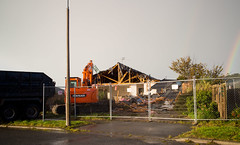
20140522_8951_EOS M-22 Demolition
Images, eqnz.chch.2010
20140522_8951_EOS M-22 Demolition Of what many in Christchurch know as the Millers building, but for many recent years was the home to the Christchurch City Council, till just a week or two before the first earthquake of 2010. Now, in mid-2014 it is finally being demolished after nearly 45 months empty. A bus is leaving the new (temporary) bu...
Geotechnical & flooding reconnaissance of the 2014 March flood event post …
Research papers, University of Canterbury Library
20140526_8961_EOS M-22 It is happening now
Images, eqnz.chch.2010
My house (bought in March 2004) till the government procured it in October 2012, is finally being demolished. It will be an empty section in a couple of days, once they rip up the concrete base. Note the rainbow on right.
Key factors in the liquefaction-induced damage to buildings and infrastruc…
Research papers, University of Canterbury Library
The paper presents preliminary findings from comprehensive research studies on the liquefaction-induced damage to buildings and infrastructure in Christchurch during the 2010-2011 Canterbury earthquakes. It identifies key factors and mechanisms of damage to road bridges, shallow foundations of CBD buildings and buried pipelines, and highlights the implications of the findings for the seismic analysis and design of these structures.
Jennifer Middendorf's Blog 22/07/2014: I'm (a tiny bit) famous!
Articles, UC QuakeStudies
An entry from Jennifer Middendorf's blog for 22 July 2014 entitled, "I'm (a tiny bit) famous!".
Where to next for our sinking city? Opinion piece in the Christchurch Pres…
Research papers, University of Canterbury Library
OPINION: Associate Professor MARK QUIGLEY, from the University of Canterbury's department of geological sciences, and Dr MATTHEW HUGHES, from its department of civil and natural resources engineering, survey the changing landscape of post-quake Christchurch.
20140904_9091_EOS M-22 23 Velsheda Street today (2014)
Images, eqnz.chch.2010
Today (04/09/14) marks the fourth anniversary since the first earthquake rocked the city and greater Christchurch area. That first quake was magnitude 7.1, and luckily there was only one fatality (possible a heart attack). Since then we have had over 14,000 quakes, most very small in magnitude, but well over 500 of magnitude 4 or greater. 5...
20140819_9054_EOS M-24 More infra-structure work!
Images, eqnz.chch.2010
More repairs to the infrastructure as a result of the 2010 & 2011 earthquakes. Boat ramp at New Brighton. Avon River.
20140819_9053_EOS M-26 More infra-structure work!
Images, eqnz.chch.2010
More repairs to the infrastructure as a result of the 2010 & 2011 earthquakes. Boat ramp at New Brighton. Avon River.
20140819_9079_EOS M-85 More infra-structure work!
Images, eqnz.chch.2010
More repairs to the infrastructure as a result of the 2010 & 2011 earthquakes. Hardy Street/Owles Terrace corner (beside the boat launching ramp), New Brighton
A 3D seismic velocity model for Canterbury, New Zealand for broadband grou…
Research papers, University of Canterbury Library
This poster presents the on-going development of a new 3D seismic velocity model of Canterbury, New Zealand. The intention of the model is to provide the 3D crustal structure in the region at multiple length scales for seismic wave propagation simulations, both broadband ground motion and more localized shallow site response analyses.
Shallow shear wave velocity characterization of the urban Christchurch, Ne…
Research papers, University of Canterbury Library
This poster provides a summary of the development of a 3D shallow (z<40m) shear wave velocity (Vs) model for the urban Christchurch, New Zealand region. The model is based on a recently developed Christchurch-specific empirical correlation between Vs and cone penetration test (CPT) data (McGann et al. 2014a,b) and the large high-density database of CPT logs in the greater Christchurch urban area (> 15,000 logs as of 01/01/2014). In particular, the 3D model provides shear wave velocities for the surficial Springston Formation, Christchurch Formation, and Riccarton gravel layers which generally comprise the upper 40m in the Christchurch urban area. Point-estimates are provided on a 200m-by- 200m grid from which interpolation to other locations can be performed. This model has applications for future site characterization and numerical modeling efforts via maps of timeaveraged Vs over specific depths (e.g. Vs30, Vs10) and via the identification of typical Vs profiles for different regions and soil behaviour types within Christchurch. In addition, the Vs model can be used to constrain the near-surface velocities for the 3D seismic velocity model of the Canterbury basin (Lee et al. 2014) currently being developed for the purpose of broadband ground motion simulation.
Comparison of existing CPT-Vs correlations with Canterbury-specific seismi…
Research papers, University of Canterbury Library
The abundance of cone penetration test (CPT) data from subsurface explorations in Christchurch and the surrounding areas provides a useful source of information for a characterization of the near surface shear wave velocity ( ) profile for the region. A portion of the investigations were conducted using seismic CPT, enabling the comparison of measured shear wave velocity with CPT data, and subsequently the evaluation of existing CPT- correlations for applicability to Canterbury-specific soils. The existing correlations are shown to be biased, generally over-predicting the observed with depth, thus demonstrating the need for a Canterbury-specific CPT- correlation.
"Then the earth shook and trembled; the foundations of the hills also move…
Research papers, University of Canterbury Library
In this paper, we consider how religious leaders and Civil Defence authorities might collaborate to establish a two-way information conduit during the aftermath of a disaster. Using surveys and in-person interviews, clergy in different Christian denominations were asked about their roles in the earthquake, the needs of their congregations and the possibilities and obstacles to deeper collaboration with Civil Defence authorities.
Staples secures $45M deal to build sustainable city houses
Audio, Radio New Zealand
A Christchurch man who's made his name battling the Earthquake Commission says he has secured a forty-five-million-dollar joint venture with a Chinese company that will regenerate Christchurch's residential areas.
CCC's bill to settle insurance claim $9M and climbing
Audio, Radio New Zealand
Official figures show the Christchurch City Council's legal bill to settle its earthquake insurance claims is sitting at nine million dollars, and climbing.
Framing Disaster Research as “Wicked” Design Problems
Research papers, The University of Auckland Library
Though generally considered “natural” disasters, cyclones and earthquakes are increasingly being associated with human activities, incubated through urban settlement patterns and the long-term redistribution of natural resources. As society is becoming more urbanized, the risk of human exposure to disasters is also rising. Architecture often reflects the state of society’s health: architectural damage is the first visible sign of emergency, and reconstruction is the final response in the process of recovery. An empirical assessment of architectural projects in post-disaster situations can lead to a deeper understanding of urban societies as they try to rebuild. This thesis offers an alternative perspective on urban disasters by looking at the actions and attitudes of disaster professionals through the lens of architecture, situated in recent events: the 2010 Christchurch earthquake, the 2010 Haiti earthquake, and the 2005 Hurricane Katrina. An empirical, multi-hazard, cross-sectional case study methodology was used, employing grounded theory method to build theory, and a critical constructivist strategy to inform the analysis. By taking an interdisciplinary approach to understanding disasters, this thesis positions architecture as a conduit between two divergent approaches to disaster research: the hazards approach, which studies the disaster cycles from a scientific perspective; and the sociological approach, which studies the socially constructed vulnerabilities that result from disasters, and the elements of social change that accompany such events. Few studies to date have attempted to integrate the multi-disciplinary perspectives that can advance our understanding of societal problems in urban disasters. To bridge this gap, this thesis develops what will be referred to as the “Rittelian framework”—based on the work of UC Berkeley’s architecture professor Horst Rittel (1930-1990). The Rittelian framework uses the language of design to transcend the multiple fields of human endeavor to address the “design problems” in disaster research. The processes by which societal problems are addressed following an urban disaster involve input by professionals from multiple fields—including economics, sociology, medicine, and engineering—but the contribution from architecture has been minimal to date. The main impetus for my doctoral thesis has been the assertion that most of the decisions related to reconstruction are made in the early emergency recovery stages where architects are not involved, but architects’ early contribution is vital to the long-term reconstruction of cities. This precipitated in the critical question: “How does the Rittelian framework contribute to the critical design decisions in modern urban disasters?” Comparative research was undertaken in three case studies of recent disasters in New Orleans (2005), Haiti (2010) and Christchurch (2010), by interviewing 51 individuals who were selected on the basis of employing the Rittelian framework in their humanitarian practice. Contextualizing natural disaster research within the robust methodological framework of architecture and the analytical processes of sociology is the basis for evaluating the research proposition that architectural problem solving is of value in addressing the ‘Wicked Problems’ of disasters. This thesis has found that (1) the nuances of the way disaster agents interpret the notion of “building back better” can influence the extent to which architectural professionals contribute in urban disaster recovery, (2) architectural design can be used to facilitate but also impede critical design decisions, and (3) framing disaster research in terms of design decisions can lead to innovation where least expected. This empirical research demonstrates how the Rittelian framework can inform a wider discussion about post-disaster human settlements, and improve our resilience through disaster research
The landscape record of blind fault earthquakes
Research papers, University of Canterbury Library
Active faults capable of generating highly damaging earthquakes may not cause surface rupture (i.e., blind faults) or cause surface ruptures that evade detection due to subsequent burial or erosion by surface processes. Fault populations and earthquake frequency-‐magnitude distributions adhere to power laws, implying that faults too small to cause surface rupture but large enough to cause localized strong ground shaking densely populate continental crust. The rupture of blind, previously undetected faults beneath Christchurch, New Zealand in a suite of earthquakes in 2010 and 2011, including the fatal 22 February 2011 moment magnitude (Mw) 6.2 Christchurch earthquake and other large aftershocks, caused a variety of environmental impacts, including major rockfall, severe liquefaction, and differential surface uplift and subsidence. All of these effects occurred where geologic evidence for penultimate effects of the same nature existed. To what extent could the geologic record have been used to infer the presence of proximal, blind and / or unidentified faults near Christchurch? In this instance, we argue that phenomena induced by high intensity shaking, such as rock fragmentation and rockfall, revealed the presence of proximal active faults in the Christchurch area prior to the recent earthquake sequence. Development of robust earthquake shaking proxy datasets should become a higher scientific priority, particularly in populated regions.
The potential of an active transport corridor along Christchurch's earthqu…
Research papers, University of Canterbury Library
A survey of community attitudes to Akaroa hosting cruise ship arrivals
Research papers, Lincoln University
Akaroa is a small township situated within Akaroa Harbour, on the southern side of Banks Peninsula. It is approximately 75 kilometres, or 90 minutes by car, from Christchurch City. At the 2006 Census of Population and Dwellings, the ‘usually resident’ population of the township was 510 people. In addition to the usually resident population, Akaroa has a large number of non-resident property owners/ratepayers, many of whom own holiday homes. Many of these holiday homes are available as casual rentals (i.e., they may be occupied by people other than the property owners). The township acts as a service centre for the scattered population of the outer bays area of Akaroa Harbour, many of whom work in Akaroa. Akaroa is a popular day trip or short stay destination for Christchurch residents. Akaroa is also known as a destination which draws upon the French heritage of its pioneer settlers and the associated village charm derived from this heritage. Not unexpectedly, given the size and village character of Akaroa, the increase in cruise ship arrivals and passenger numbers has had an impact upon the town’s community.This research was commissioned and funded by Christchurch and Canterbury Tourism (CCT).
Select liquefaction case histories from the 2010-2011 Canterbury earthquak…
Research papers, University of Canterbury Library
The 2010–2011 Canterbury earthquake sequence began with the 4 September 2010, Mw7.1 Darfield earthquake and includes up to ten events that induced liquefaction. Most notably, widespread liquefaction was induced by the Darfield and Mw6.2 Christchurch earthquakes. The combination of well-documented liquefaction response during multiple events, densely recorded ground motions for the events, and detailed subsurface characterization provides an unprecedented opportunity to add well-documented case histories to the liquefaction database. This paper presents and applies 50 high-quality cone penetration test (CPT) liquefaction case histories to evaluate three commonly used, deterministic, CPT-based simplified liquefaction evaluation procedures. While all the procedures predicted the majority of the cases correctly, the procedure proposed by Idriss and Boulanger (2008) results in the lowest error index for the case histories analyzed, thus indicating better predictions of the observed liquefaction response.
Performance of horizontal infrastructure in Christchurch city through the …
Research papers, University of Canterbury Library
This is an interim report from the research study performed within the NHRP Research Project “Impacts of soil liquefaction on land, buildings and buried pipe networks: geotechnical evaluation and design, Project 3: Seismic assessment and design of pipe networks in liquefiable soils”. The work presented herein is a continuation of the comprehensive study on the impacts of Christchurch earthquakes on the buried pipe networks presented in Cubrinovski et al. (2011). This report summarises the performance of Christchurch City’s potable water, waste water and road networks through the 2010-2011 Canterbury Earthquake Sequence (CES), and particularly focuses on the potable water network. It combines evidence based on comprehensive and well-documented data on the damage to the water network, detailed observations and interpretation of liquefaction-induced land damage, records and interpretations of ground motion characteristics induced by the Canterbury earthquakes, for a network analysis and pipeline performance evaluation using a GIS platform. The study addresses a range of issues relevant in the assessment of buried networks in areas affected by strong earthquakes and soil liquefaction. It discusses performance of different pipe materials (modern flexible pipelines and older brittle pipelines) including effects of pipe diameters, fittings and pipeline components/details, trench backfill characteristics, and severity of liquefaction. Detailed breakdown of key factors contributing to the damage to buried pipes is given with reference to the above and other relevant parameters. Particular attention is given to the interpretation, analysis and modelling of liquefaction effects on the damage and performance of the buried pipe networks. Clear link between liquefaction severity and damage rate for the pipeline has been observed with an increasing damage rate seen with increasing liquefaction severity. The approach taken here was to correlate the pipeline damage to LRI (Liquefaction Resistance Index, newly developed parameter in Cubrinovski et al., 2011) which represents a direct measure for the soil resistance to liquefaction while accounting for the seismic demand through PGA. Key quality of the adopted approach is that it provides a general methodology that in conjunction with conventional methods for liquefaction evaluation can be applied elsewhere in New Zealand and internationally. Preliminary correlations between pipeline damage (breaks km-1), liquefaction resistance (LRI) and seismic demand (PGA) have been developed for AC pipes, as an example. Such correlations can be directly used in the design and assessment of pipes in seismic areas both in liquefiable and non-liquefiable areas. Preliminary findings on the key factors for the damage to the potable water pipe network and established empirical correlations are presented including an overview of the damage to the waste water and road networks but with substantially less detail. A comprehensive summary of the damage data on the buried pipelines is given in a series of appendices.
Stars in a Cluster
Articles, UC QuakeStudies
A copy of Stars in a Cluster, a book by the Department of Physics and Astronomy at the University of Canterbury. The book was published in 1996 and edited by W. Tobin and G.M. Evans. This PDF version was created in 2014.
Urban Disaster Recovery in Christchurch: The Central Business District Cor…
Research papers, University of Canterbury Library
Copyright 2014. Earthquake Engineering Research Institute. This article may be downloaded for personal use only. Any other use requires prior permission of the Earthquake Engineering Research Institute.The Canterbury earthquakes, which involved widespread damage in the February 2011 event and ongoing aftershocks near the Christchurch central business district (CBD), presented decision-makers with many recovery challenges. This paper identifies major government decisions, challenges, and lessons in the early recovery of Christchurch based on 23 key-informant interviews conducted 15 months after the February 2011 earthquake. It then focuses on one of the most important decisions – maintaining the cordon around the heavily damaged CBD – and investigates its impacts. The cordon displaced 50,000 central city jobs, raised questions about (and provided new opportunities for) the long-term viability of downtown, influenced the number and practice of building demolitions, and affected debris management; despite being associated with substantial losses, the cordon was commonly viewed as necessary, and provided some benefits in facilitating recovery. Management of the cordon poses important lessons for planning for catastrophic urban earthquakes around the world.
Development of a Non-Destructive Field Based Method to Determine the Relat…
Research papers, The University of Auckland Library
A non-destructive hardness testing method has been developed to investigate the amount of plastic strain demand in steel elements subjected to cyclic loading. The focus of this research is on application to the active links of eccentrically braced frames (EBFs), which are a commonly used seismic-resisting system in modern steel framed buildings. The 2010/2011 Christchurch earthquake series, especially the very intense February 22 shaking, which was the first earthquake worldwide to push complete EBF systems fully into their inelastic state, generating a moderate to high level of plastic strain in EBF active links, for a range of buildings from 3 to 23 storeys in height. This raised two important questions: 1) what was the extent of plastic deformation in active links; and 2) what effect does that have to post-earthquake steel properties? This project comprised determining a robust relationship between hardness and plastic strain in order to be able to answer the first question and provide the necessary input into answering the second question. A non-destructive Leeb (portable) hardness tester (model TH170) has been used to measure the hardness, in order to determine the plastic strain, in hot rolled steel universal sections and steel plates. A bench top Rockwell B was used to compare and validated the hardness measured by the portable hardness tester. Hardness was measured from monotonically strained tensile test specimens to identify the relationship between hardness and plastic strain demand. Test results confirmed a good relationship between hardness and the amount of monotonically induced plastic strain. Surface roughness was identified as an important parameter in obtaining reliable hardness readings from a portable hardness reader. A proper surface preparation method was established by using three different cleaning methods, finished with hand sanding to achieve surface roughness coefficients sufficiently low not to distort the results. This work showed that a test surface roughness (Ra) is not more than 1.6 micron meter (μm) is required for accurate readings from the TH170 tester. A case study on an earthquake affected building was carried out to identify the relationship between hardness and amount of plastic strain demand in cyclically deformed active links. Hardness was carried out from active links shown visually to have been the most affected during one of the major earthquake events. Onsite hardness test results were then compared with laboratory hardness test results. A good relationship between hardness from onsite and laboratory was observed between the test methods; Rockwell B bench top and portable Leeb tester TH170. Manufacturing induced plastic strain in the top and bottom of the webs of hot rolled sections were discovered from this research, an important result which explains why visual effects of earthquake induced active link yielding (eg cracked or flaking paint) was typically more prevalent over the middle half depth of the active link. The extent of this was quantified. It was also evident that the hardness readings from the portable hardness tester are influenced by geometry, mass effects and rigidity of the links. The final experimental stage was application of the method to full scale cyclic inelastic tested nominally identical active links subjected to loading regimes comprising constant and variable plastic strain demands. The links were cyclically loaded to achieve different plastic strain level. A novel Digital Image Correlation (DIC) technique was incorporated during the tests of this scale, to confirm the level of plastic strain achieved. Tensile test specimens were water jet cut from cyclically deformed webs to analyse the level of plastic strain. Test results show clear evidence that cyclically deformed structural steel elements show good correlation between hardness and the amount of plastic strain demand. DIC method was found to be reliable and accurate to check the level of plastic strain within cyclically deformed structural steel elements
Rethinking PSHA
Research papers, University of Canterbury Library
Since the early 1980s seismic hazard assessment in New Zealand has been based on Probabilistic Seismic Hazard Analysis (PSHA). The most recent version of the New Zealand National Seismic Hazard Model, a PSHA model, was published by Stirling et al, in 2012. This model follows standard PSHA principals and combines a nation-wide model of active faults with a gridded point-source model based on the earthquake catalogue since 1840. These models are coupled with the ground-motion prediction equation of McVerry et al (2006). Additionally, we have developed a time-dependent clustering-based PSHA model for the Canterbury region (Gerstenberger et al, 2014) in response to the Canterbury earthquake sequence. We are now in the process of revising that national model. In this process we are investigating several of the fundamental assumptions in traditional PSHA and in how we modelled hazard in the past. For this project, we have three main focuses: 1) how do we design an optimal combination of multiple sources of information to produce the best forecast of earthquake rates in the next 50 years: can we improve upon a simple hybrid of fault sources and background sources, and can we better handle the uncertainties in the data and models (e.g., fault segmentation, frequency-magnitude distributions, time-dependence & clustering, low strain-rate areas, and subduction zone modelling)? 2) developing revised and new ground-motion predictions models including better capturing of epistemic uncertainty – a key focus in this work is developing a new strong ground motion catalogue for model development; and 3) how can we best quantify if changes we have made in our modelling are truly improvements? Throughout this process we are working toward incorporating numerical modelling results from physics based synthetic seismicity and ground-motion models.
Recent efforts in empirical ground motion modelling in New Zealand
Research papers, University of Canterbury Library
This presentation discusses recent empirical ground motion modelling efforts in New Zealand. Firstly, the active shallow crustal and subduction interface and slab ground motion prediction equations (GMPEs) which are employed in the 2010 update of the national seismic hazard model (NSHM) are discussed. Other NZ-specific GMPEs developed, but not incorporated in the 2010 update are then discussed, in particular, the active shallow crustal model of Bradley (2010). A brief comparison of the NZ-specific GMPEs with the near-source ground motions recorded in the Canterbury earthquakes is then presented, given that these recordings collectively provide a significant increase in observed strong motions in the NZ catalogue. The ground motion prediction expert elicitation process that was undertaken following the Canterbury earthquakes for active shallow crustal earthquakes is then discussed. Finally, ongoing GMPE-related activities are discussed including: ground motion and metadata database refinement, improved site characterization of strong motion station, and predictions for subduction zone earthquakes.
Evaluating the Efficacy of Paleoliquefaction Analysis Techniques Using Mod…
Research papers, University of Canterbury Library
Using case studies from the 2010-2011 Canterbury, New Zealand earthquake sequence, this study assesses the accuracies of paleoliquefaction back-analysis methods and explores the challenges, techniques, and uncertainties associated with their application. While liquefaction-based back-analyses have been widely used to estimate the magnitudes of paleoearthquakes, their uncertain efficacies continue to significantly affect the computed seismic hazard in regions where they are relied upon. Accordingly, their performance is evaluated herein using liquefaction data from modern earthquakes with known magnitudes. It is shown that when the earthquake source location and mechanism are known, back-analysis methods are capable of accurately deriving seismic parameters from liquefaction evidence. However, because the source location and mechanism are often unknown in paleoseismic studies, and because accurate interpretation is shown to be more difficult in such cases, new analysis techniques are proposed herein. An objective parameter is proposed to geospatially assess the likelihood of any provisional source location, enabling an analyst to more accurately estimate the magnitude of a liquefaction-inducing paleoearthquake. This study demonstrates the application of back-analysis methods, provides insight into their potential accuracies, and provides a framework for performing paleoliquefaction analyses worldwide.
Ongoing development of a 3D seismic velocity model for Canterbury, New Zea…
Research papers, University of Canterbury Library
This paper presents the ongoing development of a new 3D seismic velocity model of Canterbury, New Zealand. The model explicitly represents the Canterbury sedimentary basin, and other significant geologic horizons, which are expected to have important implications on observed ground motions. The model utilizes numerous sources of data, including 3D regional tomography with a variable-depth inferred Moho, seismic reflection survey lines, geotechnical boreholes and well logs, spectral analysis of surface waves, and CPT logs which provide velocity constraints over their respective ranges of application. The model provides P- and S-wave velocity and density (i.e. Vp, Vs and p) over a grid of input points, and is presently being utilized in broadband ground motion simulations of the 2010-2011 Canterbury earthquakes. Comparison of simulated ground motions with those observed in the 2010-2011 Canterbury earthquakes will help provide a better understanding of the salient physical processes which characterized the unique set of strong ground motions recorded in this sequence of earthquake events.
- 1
- »