
Search
found 53 results
Images for EQNZ; more images...


At South Brighton
Images, eqnz.chch.2010
None
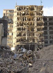
20121112_2364_G12-12 Farmers Carpark Building
Images, eqnz.chch.2010
Being demolished.
2,City Hotel Demolition
Images, eqnz.chch.2010
None
SydenhamED-5392
Images, eqnz.chch.2010
None
Christchurch City
Images, eqnz.chch.2010
Helicopter Flight over Christchurch New Zealand
Lancaster Park
Images, eqnz.chch.2010
Helicopter Flight over Christchurch New Zealand
Christchurch City
Images, eqnz.chch.2010
Helicopter Flight over Christchurch New Zealand
Christchurch, NZ - Damaged Facade
Images, eqnz.chch.2010
None
BNZ building, Kaiapoi on a lean
Images, eqnz.chch.2010
None
After-Ward
Images, eqnz.chch.2010
Lomography-Style
Some of the remains of the earthquake damaged Cathedral of the Blessed Sac…
Images, eqnz.chch.2010
None
Emergency Response
Images, eqnz.chch.2010
A few older Christchurch Earthquake Pics from after the 6.3 last Feb (2011). And yes the aftershocks are still happening.. Twitter | Facebook |
Christchurch Earthquake – Street Cone Commemoration
Images, eqnz.chch.2010
Commemorating our one year anniversary of the 22 February 2011 Christchurch 6.3 earthquake.
20120805_7566_1D3-600 Newstalk ZB building starting to go down 131
Images, eqnz.chch.2010
None
20121117_2387_G12-06 New Brighton Road flooded again
Images, eqnz.chch.2010
With the land dropping about 1metre to 1.4metres after the earthquakes, a few roads besides the Avon and Heathcote Rivers are flooded with very high tides. Extra stop banks (on right) erected after the quakes have helped, but the road is now well below high water level. New Brighton Road, just short of New Brighton. The Pages Road bridge may b...
20120702_1387_G12-18 Another one bites the dust
Images, eqnz.chch.2010
8 Velsheda Street, Bexley, Christchurch, across the road from my house was demolished a week or so ago, just one of many demolitions of Red Zone properties at the moment. This house was about ten years old and suffered land damage during the 4th September 2010 and 22nd February 2011 earthquakes. The same fate awaits my house later in the year o...
20120805_7446_1D3-600 Newstalk ZB building starting to go down 11
Images, eqnz.chch.2010
None
20120805_7456_1D3-600 Newstalk ZB building starting to go down 21
Images, eqnz.chch.2010
None
20120805_7576_1D3-600 Newstalk ZB building starting to go down 141
Images, eqnz.chch.2010
None
20120805_7461_1D3-600 Newstalk ZB building starting to go down 26
Images, eqnz.chch.2010
None
Christchurch Earthquake 2011 - Stanmore
Images, eqnz.chch.2010
Revisiting some of my images coming up to our one year anniversary of the 22 February 2011 Christchurch 6.3 earthquake.
Bringing the house down
Images, eqnz.chch.2010
www.youtube.com/watch?v=SPXqb7k4azU Details inside a half demolished theatre in central Christchurch. November, 2012. Christchurch, NZ. (c)Mike Brebner. All rights reserved.
20120805_7451_1D3-600 Newstalk ZB building starting to go down 16
Images, eqnz.chch.2010
None
20120131_8198_1D3-400 Eathquake damage
Images, eqnz.chch.2010
Damaged houses above Shag Rock.
20120805_7441_1D3-600 Newstalk ZB building starting to go down 06
Images, eqnz.chch.2010
20120805_7441_1D3-600 Newstalk ZB building starting to go down 06 #2642
30 seconds later the dust drifts across the city.
Images, eqnz.chch.2010
20120805_7586_1D3-600 30 seconds later the dust drifts across the city. Following the demolition of the earthquake damaged Newstalk ZB building. #2649
20120827_2023_G12-08 Container about to be unloaded
Images, eqnz.chch.2010
RWTU3388135 (ex Triton TTNU3388135) about to be placed on the ground outside my "Red Zone" house. This is the second container, the first is away in storage with 95% of the house hold stuff. This one is for the hobby (no, not photography gear) and garage stuff.
20120718_1497_G12-25 New Brighton icon is demolished
Images, eqnz.chch.2010
The old New Brighton Power Boat Club building was badly damaged in the February 2011 earthquake, and is only now (July 2012) being demolished. The building is just down the road from where I grew up and is a New Brighton iconic building.
20120718_1499_G12-9 New Brighton icon is demolished
Images, eqnz.chch.2010
The old New Brighton Power Boat Club building was badly damaged in the February 2011 earthquake, and is only now (July 2012) being demolished. The building is just down the road from where I grew up and is a New Brighton iconic building.
wairoa street red zone
Images, eqnz.chch.2010
one of Christchurch's abandoned suburbs. The land moved - bricks and block walls everywhere collapsed - two multi story buildings folded - 184 people died. Wooden framed houses largely stayed up, many concrete slabs cracked, power poles leaned in liquid ground, surface bubbled, services ruptured .... damage to the cbd still gets the most cover...
- 1
- »