Search
found 51 results
Images for Christchurch earthquake damage; more images...


Iconic Christchurch clocktower restored
Audio, Radio New Zealand
An historic Christchurch clock tower damaged in the earthquakes was unveiled today, after undergoing more than eight hundred thousand dollars of repairs.
Restoration of Christchurch Arts Centre makes progress
Audio, Radio New Zealand
Christchurch's iconic Arts Centre has been off-limits to the public since it was damaged in the Christchurch earthquakes.
The Demise of the URM Building Stock in Christchurch during the 2010–2011 …
Research papers, The University of Auckland Library
The progressive damage and subsequent demolition of unreinforced masonry (URM) buildings arising from the Canterbury earthquake sequence is reported. A dataset was compiled of all URM buildings located within the Christchurch CBD, including information on location, building characteristics, and damage levels after each major earthquake in this sequence. A general description of the overall damage and the hazard to both building occupants and to nearby pedestrians due to debris falling from URM buildings is presented with several case study buildings used to describe the accumulation of damage over the earthquake sequence. The benefit of seismic improvement techniques that had been installed to URM buildings is shown by the reduced damage ratios reported for increased levels of retrofit. Demolition statistics for URM buildings in the Christchurch CBD are also reported and discussed. VoR - Version of Record
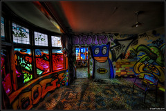
Graffiti House Christchurch
Images, eqnz.chch.2010
Christchurch's Graffiti House... This Cranford Street house was damaged in the earthquakes and is due for demolished this week but has been given a Graffiti Makeover by local Street Artists.
Quake victims welcome idea of earthquake court
Audio, Radio New Zealand
Christchurch people who have had to battle insurance companies over the repair or rebuild of earthquake damaged homes are welcoming the Labour party's idea of an earthquake court to settle disputes.
Jennifer Middendorf's Blog 30/08/2014: A photographic tour of Christchurch
Articles, UC QuakeStudies
An entry from Jennifer Middendorf's blog for 30 August 2014 entitled, "A photographic tour of Christchurch".
Key factors in the liquefaction-induced damage to buildings and infrastruc…
Research papers, University of Canterbury Library
The paper presents preliminary findings from comprehensive research studies on the liquefaction-induced damage to buildings and infrastructure in Christchurch during the 2010-2011 Canterbury earthquakes. It identifies key factors and mechanisms of damage to road bridges, shallow foundations of CBD buildings and buried pipelines, and highlights the implications of the findings for the seismic analysis and design of these structures.
Midday News for 14 April 2014
Audio, Radio New Zealand
The Duke and Duchess of Cambridge are in Christchurch and the Solomon Islands escapes serious damage despite major earthquakes.
CCC and EQC in talks about area-wide land remediation for CHCH
Audio, Radio New Zealand
Owners of earthquake-damaged land in Christchurch may not get an individual payout from the Earthquake Commission if it goes ahead instead with a more widespread approach to fixing the land.
Fairfax Video, January 2014 (1)
Videos, UC QuakeStudies
A video of quotes from members of the public about the Christchurch Cathedral. The quotes are superimposed over images of the public viewing the earthquake-damaged cathedral.
Road Closed
Images, eqnz.chch.2010
Earthquake damaged building on a Walk around the city, May 1, 2014 Christchurch New Zealand. Demolition work on Christchurch's "distinctive" former civic building is under way. The category-2 heritage building was designed by G A J Hart and opened in 1939 as the Miller's department store. It featured the South Island's first escalator, which...
Performance of horizontal infrastructure in Christchurch city through the …
Research papers, University of Canterbury Library
This is an interim report from the research study performed within the NHRP Research Project “Impacts of soil liquefaction on land, buildings and buried pipe networks: geotechnical evaluation and design, Project 3: Seismic assessment and design of pipe networks in liquefiable soils”. The work presented herein is a continuation of the comprehensive study on the impacts of Christchurch earthquakes on the buried pipe networks presented in Cubrinovski et al. (2011). This report summarises the performance of Christchurch City’s potable water, waste water and road networks through the 2010-2011 Canterbury Earthquake Sequence (CES), and particularly focuses on the potable water network. It combines evidence based on comprehensive and well-documented data on the damage to the water network, detailed observations and interpretation of liquefaction-induced land damage, records and interpretations of ground motion characteristics induced by the Canterbury earthquakes, for a network analysis and pipeline performance evaluation using a GIS platform. The study addresses a range of issues relevant in the assessment of buried networks in areas affected by strong earthquakes and soil liquefaction. It discusses performance of different pipe materials (modern flexible pipelines and older brittle pipelines) including effects of pipe diameters, fittings and pipeline components/details, trench backfill characteristics, and severity of liquefaction. Detailed breakdown of key factors contributing to the damage to buried pipes is given with reference to the above and other relevant parameters. Particular attention is given to the interpretation, analysis and modelling of liquefaction effects on the damage and performance of the buried pipe networks. Clear link between liquefaction severity and damage rate for the pipeline has been observed with an increasing damage rate seen with increasing liquefaction severity. The approach taken here was to correlate the pipeline damage to LRI (Liquefaction Resistance Index, newly developed parameter in Cubrinovski et al., 2011) which represents a direct measure for the soil resistance to liquefaction while accounting for the seismic demand through PGA. Key quality of the adopted approach is that it provides a general methodology that in conjunction with conventional methods for liquefaction evaluation can be applied elsewhere in New Zealand and internationally. Preliminary correlations between pipeline damage (breaks km-1), liquefaction resistance (LRI) and seismic demand (PGA) have been developed for AC pipes, as an example. Such correlations can be directly used in the design and assessment of pipes in seismic areas both in liquefiable and non-liquefiable areas. Preliminary findings on the key factors for the damage to the potable water pipe network and established empirical correlations are presented including an overview of the damage to the waste water and road networks but with substantially less detail. A comprehensive summary of the damage data on the buried pipelines is given in a series of appendices.
Lessons from the 2011 Christchurch earthquake for improving the seismic pe…
Research papers, The University of Auckland Library
The 2011, 6.3 magnitude Christchurch earthquake in New Zealand caused considerable structural damage. It is believed that this event has now resulted in demolition of about 65-70% of the building stock in the Central Business District (CBD), significantly crippling economic activities in the city of Christchurch. A major concern raised from this event was adequacy of the current seismic design practice adopted for reinforced concrete walls due to their poor performance in modern buildings. The relatively short-duration earthquake motion implied that the observed wall damage occurred in a brittle manner despite adopting a ductile design philosophy. This paper presents the lessons learned from the observed wall damage in the context of current state of knowledge in the following areas: concentrating longitudinal reinforcement in wall end regions; determining wall thickness to prevent out-of-plane wall buckling; avoiding lap splices in plastic hinge zones; and quantifying minimum vertical reinforcement. http://www.2eceesistanbul.org/
Performance of the Christchurch, New Zealand cathedral during the M7.1 201…
Research papers, The University of Auckland Library
The Catholic Cathedral is classified as a category 1 listed heritage building constructed largely of unreinforced stone masonry, and was significantly damaged in the recent Canterbury earthquakes of 2010 and 2011. In the 2010 event the building presented slight to moderta damage, meanwhile in the 2011 one experienced ground shaking in excess of its capacity leading to block failures and partial collapse of parts of the building, which left the building standing but still posing a significant hazard. In this paper we discuss the approach to develop the earthquake analysis of the building by 3D numerical simulations, and the results are compared/calibrated with the observed damage of the 2010 earthquake. Very accurate records were obtained during both earthquakes due to a record station located least than 80 m of distance from the building and used in the simulations. Moreover it is included in the model the soil structure interaction because it was observed that the ground and foundation played an important role on the seismic behavior of the structure. A very good agreement was found between the real observed damage and the nonlinear dynamic simulations described trough inelastic deformation (cracking) and building´s performance.
Going in!
Images, eqnz.chch.2010
Working at getting things out of the Victoria Square before it is demolished. www.stuff.co.nz/the-press/news/christchurch-earthquake-20... What I found on my walk around the city January 15, 2014 Ch...
Restoration of Arts Centre reveals hidden gems
Audio, Radio New Zealand
The repair of Christchurch's earthquake damaged arts centre has revealed details hidden from view for forty years including a badminton court and the site of an old swimming pool.
8 million given to quake-damage community groups
Audio, Radio New Zealand
A school pool, a BMX bike club and a music school are among twenty organisations in Christchurch that have benefitted from the final grants from an international appeal for re-building the quake-damaged city. The Christchurch Earthquake Appeal has so far raised almost 100 million dollars, and as our reporter Teresa Cowie discovered, the latest 8 million dollars that's been released from the fund is giving a welcome boost to residents.
Housing affordability in post-earthquake Christchurch
Research papers, Lincoln University
"Prior to the devastating 2010-2011 Canterbury earthquakes, the city of Christchurch was already exhibiting signs of a housing affordability crisis. The causes and symptoms were similar to those being experienced in Auckland, but the substantial damage to the housing stock caused by the earthquakes added new dimensions and impetus to the problem. Large swathes of the most affordable housing stock in the east of the city were effectively destroyed by the earthquakes. In itself this would have pushed the mean house price upwards, but compounding problems exacerbated the situation. These include the price effects of reduced supply of both rented and owned housing and increased demand from both displaced residents and an influx of rebuild workers. The need for additional temporary housing while repairs were undertaken and the associated insurance pay-outs bidding up rents with improved rental returns leading to increased interest in property investment. Land supply constraints and consenting issues inhibiting the build of new housing and political infighting and uncertainty regarding the future of parts of the city leading to a flight of development activity to peripheral locations and adjoining local authorities. Concerns that the erosion of the city council rating base combined with inadequacy of insurance cover for infrastructure will lead to large rates increases, increased development costs and reduced amenities and services in future years. These and other issuers will be elaborated on in this paper with a view to exploring the way forward for affordable housing Christchurch City."
The potential of an active transport corridor along Christchurch's earthqu…
Research papers, University of Canterbury Library
None
Red zone stayers come to grips with life in abandoned suburbs
Audio, Radio New Zealand
Most of Christchurch's earthquake damaged red zones are now almost clear of homes, but just over a hundred homeowners are now learning what life will be like once everyone else has gone.
Urban Disaster Recovery in Christchurch: The Central Business District Cor…
Research papers, University of Canterbury Library
The Canterbury earthquakes, which involved widespread damage in the February 2011 event and ongoing aftershocks near the Christchurch central business district (CBD), presented decision-makers with many recovery challenges. This paper identifies major government decisions, challenges, and lessons in the early recovery of Christchurch based on 23 key-informant interviews conducted 15 months after the February 2011 earthquake. It then focuses on one of the most important decisions – maintaining the cordon around the heavily damaged CBD – and investigates its impacts. The cordon displaced 50,000 central city jobs, raised questions about (and provided new opportunities for) the long-term viability of downtown, influenced the number and practice of building demolitions, and affected debris management; despite being associated with substantial losses, the cordon was commonly viewed as necessary, and provided some benefits in facilitating recovery. Management of the cordon poses important lessons for planning for catastrophic urban earthquakes around the world.
The Shaken Suburbs: The changing sense of home and creating a new home aft…
Research papers, University of Canterbury Library
The 2010 and 2011 earthquakes in the region of Canterbury, New Zealand caused widespread damage and the deaths of 185 people. Suburbs on the eastern side of Christchurch and in the satellite town of Kaiapoi, 20 kilometres north of Christchurch, were badly damaged by liquefaction. The Canterbury Earthquake Recovery Authority (CERA), a government organisation set up in the wake of the earthquakes, began to systematically zone all residential land in 2011. Based on the possibility for land remediation, 7860 houses in Christchurch and Kaiapoi were zoned red. Those who were in this zone were compensated and had to buy or build elsewhere. The other zone examined within this research – that of TC3 – lies within the green zone. Residents, in this zone, were able to stay in their houses but land was moderately damaged and required site-specific geotechnical investigations. This research sought to understand how residents’ senses of home were impacted by a disaster and the response efforts. Focusing on the TC3 and red zone of the eastern suburbs and the satellite town of Kaiapoi, this study interviewed 29 residents within these zones. The concept of home was explored with the respondents at three scales: home as a household; home as a community; and home as a city. There was a large amount of resistance to the zoning process and the handling of claims by insurance companies and the Earthquake Commission (EQC) after the earthquakes. Lack of transparency and communication, as well as extremely slow timelines were all documented as failings of these agencies. This research seeks to understand how participant’s sense of home changed on an individual level and how it was impacted by outside agencies. Homemaking techniques were also focused on showing that a changed sense of home will impact on how a person interacts with a space.
Neil Cox: Christchurch Theatre Royal CEO
Audio, Radio New Zealand
Christchurch's historic Theatre Royal will reopen for business in November, with bookings about to open for the first show, the Royal New Zealand Ballet season of "A Christmas Carol" The 106-year old theatre has been closed for almost four years because of earthquake damage in the 2010 and 2011 earthquakes. The $40million rebuild and restoration project will be completed over the next five months and on 17 November 2014, the 'Grand Old Lady' of New Zealand theatre will reopen her doors for performances. With so few venues for performance left in the city, including the Town Hall out of commission indefinitely, the rebuild of the Theatre Royal is very good news for Christchurch audiences Chief executive Neil Cox explains the process of getting oldest Edwardian theatre in the country back in use and mounting the large scale theatrical productions it has been famous for.
Soil Liquefaction during Recent Large-Scale Earthquakes
Research papers, The University of Auckland Library
Soil Liquefaction during Recent Large-Scale Earthquakes contains selected papers presented at the New Zealand – Japan Workshop on Soil Liquefaction during Recent Large-Scale Earthquakes (Auckland, New Zealand, 2-3 December 2013). The 2010-2011 Canterbury earthquakes in New Zealand and the 2011 off the Pacific Coast of Tohoku Earthquake in Japan have caused significant damage to many residential houses due to varying degrees of soil liquefaction over a very wide extent of urban areas unseen in past destructive earthquakes. While soil liquefaction occurred in naturally-sedimented soil formations in Christchurch, most of the areas which liquefied in Tokyo Bay area were reclaimed soil and artificial fill deposits, thus providing researchers with a wide range of soil deposits to characterize soil and site response to large-scale earthquake shaking. Although these earthquakes in New Zealand and Japan caused extensive damage to life and property, they also serve as an opportunity to understand better the response of soil and building foundations to such large-scale earthquake shaking. With the wealth of information obtained in the aftermath of both earthquakes, information-sharing and knowledge-exchange are vital in arriving at liquefaction-proof urban areas in both countries. Data regarding the observed damage to residential houses as well as the lessons learnt are essential for the rebuilding efforts in the coming years and in mitigating buildings located in regions with high liquefaction potential. As part of the MBIE-JSPS collaborative research programme, the Geomechanics Group of the University of Auckland and the Geotechnical Engineering Laboratory of the University of Tokyo co-hosted the workshop to bring together researchers to review the findings and observations from recent large-scale earthquakes related to soil liquefaction and discuss possible measures to mitigate future damage. http://librarysearch.auckland.ac.nz/UOA2_A:Combined_Local:uoa_alma21151785130002091
Photographic Services Photograph 07
Images, UC QuakeStudies
A photograph of Graeme Kershaw, Technician at the University of Canterbury Department of Physics and Astronomy, scratching his head as he looks at the damaged clock drive of the Townsend Telescope. The telescope was damaged during the 22 February 2011 earthquake, when the Observatory tower at the Christchurch Arts Centre collapsed. Kershaw has been given the task of restoring the telescope.
Just a Shell of Its Self
Images, eqnz.chch.2010
Earthquake damaged building on a Walk around the city, May 1, 2014 Christchurch New Zealand. Demolition work on Christchurch's "distinctive" former civic building is under way. The category-2 heritage building was designed by G A J Hart and opened in 1939 as the Miller's department store. It featured the South Island's first escalator, which...
The landscape record of blind fault earthquakes
Research papers, University of Canterbury Library
Active faults capable of generating highly damaging earthquakes may not cause surface rupture (i.e., blind faults) or cause surface ruptures that evade detection due to subsequent burial or erosion by surface processes. Fault populations and earthquake frequency-‐magnitude distributions adhere to power laws, implying that faults too small to cause surface rupture but large enough to cause localized strong ground shaking densely populate continental crust. The rupture of blind, previously undetected faults beneath Christchurch, New Zealand in a suite of earthquakes in 2010 and 2011, including the fatal 22 February 2011 moment magnitude (Mw) 6.2 Christchurch earthquake and other large aftershocks, caused a variety of environmental impacts, including major rockfall, severe liquefaction, and differential surface uplift and subsidence. All of these effects occurred where geologic evidence for penultimate effects of the same nature existed. To what extent could the geologic record have been used to infer the presence of proximal, blind and / or unidentified faults near Christchurch? In this instance, we argue that phenomena induced by high intensity shaking, such as rock fragmentation and rockfall, revealed the presence of proximal active faults in the Christchurch area prior to the recent earthquake sequence. Development of robust earthquake shaking proxy datasets should become a higher scientific priority, particularly in populated regions.
Indigenous Peoples and urban disaster: Māori responses to the 2010-12 Chri…
Research papers, Lincoln University
Indigenous Peoples retain traditional coping strategies for disasters despite the marginalisation of many Indigenous communities. This article describes the response of Māori to the Christchurch earthquakes of 2010 and 2012 through analyses of available statistical data and reports, and interviews done three months and one year after the most damaging event. A significant difference between Māori and ‘mainstream’ New Zealand was the greater mobility enacted by Māori throughout this period, with organisations having roles beyond their traditional catchments throughout the disaster, including important support for non-Māori. Informed engagement with Indigenous communities, acknowledging their internal diversity and culturally nuanced support networks, would enable more efficient disaster responses in many countries.
Photographic Services Photograph 01
Images, UC QuakeStudies
A photograph of Graeme Kershaw, Technician at the University of Canterbury Department of Physics and Astronomy, sitting among the damaged parts of the Townsend Telescope. The telescope was damaged during the 22 February 2011 earthquake, when the Observatory tower at the Christchurch Arts Centre collapsed. Kershaw has been given the task of restoring the telescope. In this photograph he is holding the telescope's clock drive.
Photographic Services Photograph 02
Images, UC QuakeStudies
A photograph of Graeme Kershaw, Technician at the University of Canterbury Department of Physics and Astronomy, sitting among the damaged parts of the Townsend Telescope. The telescope was damaged during the 22 February 2011 earthquake, when the Observatory tower at the Christchurch Arts Centre collapsed. Kershaw has been given the task of restoring the telescope. In this photograph he is holding the telescope's clock drive.
- 1
- »