
Search
found 9 results
Images for 5d2; more images...


20160419_7732_7D2-400 The City is in Rebuild phase (110/366)
Images, eqnz.chch.2010
20160419_7732_7D2-400 The City is in Rebuild phase (110/366) A totally different view to a few years ago. Most of the tall buildings have gone and construction is underway on a lot of new buildings, View from across the Estuary in Redcliffs. A couple of days ago the government agency controlling the post-earthquake work (CERA - Canterbury Ea...
Porritt Park
Images, eqnz.chch.2010
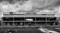
20160104_1602_7D2-20 Porritt Park Porritt Park was, before the earthquakes, the headquarters of hockey in this region. Two astro-turf fields (the main one was to the left of the building), and corporate offices etc. The earthquakes buckled all the playing surfaces and damaged the buildings; a couple of smaller ones have been removed. Hocke...
20160104_1608_7D2-20 Porritt Park (004/366)
Images, eqnz.chch.2010
Porritt Park was, before the earthquakes, the headquarters of hockey in this region. Two astro-turf fields (the main one was other side of the building), and corporate offices etc. The earthquakes buckled all the playing surfaces and damaged the buildings; a couple of smaller ones have been removed. Hockey shifted the other side of the city t...
The future face of Christchurch?
Images, eqnz.chch.2010
20161112_9961_7D2-70 The future face of Christchurch? Cultivate Christchurch is operating this urban farm in the city, about 5-10 minutes walk to Cathedral Square. Many of the buildings in this area were demolished after the earhquakes, and in the background is a new building on Kilmore Street.
Ground Motion Simulation Validation using Small-to-Moderate Magnitude Even…
Research papers, University of Canterbury Library
This poster presents work to date on ground motion simulation validation and inversion for the Canterbury, New Zealand region. Recent developments have focused on the collection of different earthquake sources and the verification of the SPECFEM3D software package in forward and inverse simulations. SPECFEM3D is an open source software package which simulates seismic wave propagation and performs adjoint tomography based upon the spectral-element method. Figure 2: Fence diagrams of shear wave velocities highlighting the salient features of the (a) 1D Canterbury velocity model, and (b) 3D Canterbury velocity model. Figure 5: Seismic sources and strong motion stations in the South Island of New Zealand, and corresponding ray paths of observed ground motions. Figure 3: Domain used for the 19th October 2010 Mw 4.8 case study event including the location of the seismic source and strong motion stations. By understanding the predictive and inversion capabilities of SPECFEM3D, the current 3D Canterbury Velocity Model can be iteratively improved to better predict the observed ground motions. This is achieved by minimizing the misfit between observed and simulated ground motions using the built-in optimization algorithm. Figure 1 shows the Canterbury Velocity Model domain considered including the locations of small-to-moderate Mw events [3-4.5], strong motion stations, and ray paths of observed ground motions. The area covered by the ray paths essentially indicates the area of the model which will be most affected by the waveform inversion. The seismic sources used in the ground motion simulations are centroid moment tensor solutions obtained from GeoNet. All earthquake ruptures are modelled as point sources with a Gaussian source time function. The minimum Mw limit is enforced to ensure good signal-to-noise ratio and well constrained source parameters. The maximum Mw limit is enforced to ensure the point source approximation is valid and to minimize off-fault nonlinear effects.
Liquefaction features produced by the 2010-2011 Canterbury earthquake sequ…
Research papers, Lincoln University
Liquefaction features and the geologic environment in which they formed were carefully studied at two sites near Lincoln in southwest Christchurch. We undertook geomorphic mapping, excavated trenches, and obtained hand cores in areas with surficial evidence for liquefaction and areas where no surficial evidence for liquefaction was present at two sites (Hardwick and Marchand). The liquefaction features identified include (1) sand blows (singular and aligned along linear fissures), (2) blisters or injections of subhorizontal dikes into the topsoil, (3) dikes related to the blows and blisters, and (4) a collapse structure. The spatial distribution of these surface liquefaction features correlates strongly with the ridges of scroll bars in meander settings. In addition, we discovered paleoliquefaction features, including several dikes and a sand blow, in excavations at the sites of modern liquefaction. The paleoliquefaction event at the Hardwick site is dated at A.D. 908-1336, and the one at the Marchand site is dated at A.D. 1017-1840 (95% confidence intervals of probability density functions obtained by Bayesian analysis). If both events are the same, given proximity of the sites, the time of the event is A.D. 1019-1337. If they are not, the one at the Marchand site could have been much younger. Taking into account a preliminary liquefaction-triggering threshold of equivalent peak ground acceleration for an Mw 7.5 event (PGA7:5) of 0:07g, existing magnitude-bounded relations for paleoliquefaction, and the timing of the paleoearthquakes and the potential PGA7:5 estimated for regional faults, we propose that the Porters Pass fault, Alpine fault, or the subduction zone faults are the most likely sources that could have triggered liquefaction at the study sites. There are other nearby regional faults that may have been the source, but there is no paleoseismic data with which to make the temporal link.
20160307_6619_7D2-125 Covering up
Images, eqnz.chch.2010
One of the most beautiful pieces of wall art (added to the blank walls after buildings were demolished following the earthquakes) in Christchurch, is now being hidden by a new building in front of it. www.flickr.com/photos/johnstewartnz/15499321681/in/...
20160307_6626_7D2-200 Pigeon City
Images, eqnz.chch.2010
Pigeons sit on the remains of one of the tallest buildings in Christchurch that was 95% demolished two or three years ago. The basement (now filled with water) and the columns remain. Demolished due to damage from the Christchurch 2011 earthquake.
20160307_6607_7D2-110 Interior removal
Images, eqnz.chch.2010
The Forsyth Barr building has stood silent and empty (except the occasional intruder and pigeons) since the February 2011 earthquake. It was sold "as is" and I understand that it is now going to be fitted out as a hotel. This is the building that had severe stairwell damage during the quake necessitating people being lowered via ropes etc on t...
- 1