
Search
found 73 results
Images for 2011 Christchurch earthquake; more images...

Digital Photograph: First Responders at the Canterbury Earthquake Memorial…
Images, Canterbury Museum
One landscape colour digital photograph taken 22 February 2017 showing first responders at the Canterbury Earthquake Memorial Service.
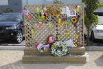
Digital Photograph: Earthquake Memorial Trellis
Images, Canterbury Museum
One landscape colour digital photograph taken 22 February 2017 showing an earthquake memorial trellis at the site of the former Canterbury Television building.
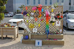
Digital Photograph: Earthquake Memorial Trellis
Images, Canterbury Museum
One landscape colour digital photograph taken 22 February 2017 showing an earthquake memorial trellis at the site of the former Canterbury Television building.
Digital Photograph: Guests Arriving at the Canterbury Earthquake Memorial …
Images, Canterbury Museum
One landscape colour digital photograph taken 22 February 2017 showing guests being seated prior to the Canterbury Earthquake Memorial Service.
Digital Photograph: Members of the Media at the Canterbury Earthquake Memo…
Images, Canterbury Museum
One landscape colour digital photograph taken 22 February 2017 showing cameramen and journalists at the Canterbury Earthquake Memorial Service.
Digital Photograph: Media Viewing Area at the Canterbury Earthquake Memori…
Images, Canterbury Museum
One landscape colour digital photograph taken 22 February 2017 showing the appointed media viewing area at the Canterbury Earthquake Memorial Service.
Digital Photograph: First Responders Laying Wreaths at the Canterbury Eart…
Images, Canterbury Museum
One landscape colour digital photograph taken 22 February 2017 showing first responders laying wreaths at the Canterbury Earthquake Memorial Service.
Digital Photograph: Commemoration Board at the Canterbury Earthquake Memor…
Images, Canterbury Museum
One landscape colour digital photograph taken 22 February 2017 showing a gentleman reading messages on a commemoration board at the Canterbury Earthquake Memorial Service.
Digital Photograph: First Responders and Public Viewing Areas at the Cante…
Images, Canterbury Museum
One landscape colour digital photograph taken 22 February 2017 showing the appointed first responders and public viewing areas at the Canterbury Earthquake Memorial Service.
Digital Photograph: Flowers on an Earthquake Memorial Trellis
Images, Canterbury Museum
One landscape colour digital photograph taken 22 February 2017 showing a bouquet of flowers and a note attached to an earthquake memorial trellis at the site of the former Canterbury Television building.
Digital Photograph: Brass Band at the Canterbury Earthquake Memorial Servi…
Images, Canterbury Museum
One landscape colour digital photograph taken 22 February 2017 showing brass band members at the Canterbury Earthquake Memorial Service. Behind the band is a digital screen showing words of thanks from survivors.
Digital Photograph: Karen Bishop at an Earthquake Memorial Trellis
Images, Canterbury Museum
One landscape colour digital photograph taken 22 February 2017 showing Karen Bishop attaching a windmill to an earthquake memorial trellis in memory of her son Andrew Bishop at the site of the former Canterbury Television building.
Digital Photograph: Brass Band at the Canterbury Earthquake Memorial Servi…
Images, Canterbury Museum
One landscape colour digital photograph taken 22 February 2017 showing brass band members at the Canterbury Earthquake Memorial Service. Behind the band is a digital screen showing an image of flowers floating in the Avon River.
Digital Photograph: Windmill Attached to an Earthquake Memorial Trellis
Images, Canterbury Museum
One landscape colour digital photograph taken 22 February 2017 showing a windmill attached to an earthquake memorial trellis by Karen Bishop in memory of her son Andrew Bishop at the site of the former Canterbury Television building.
Music back at the Christchurch Town Hall
Audio, Radio New Zealand
For the first time in six years, music has filled Christchurch's Town Hall, which suffered significant damage in the February 2011 earthquake.
Digital Photograph: Flowers Floating in the Avon River
Images, Canterbury Museum
One landscape colour digital photograph taken 22 February 2017 showing flowers floating in the Avon River as part of the Canterbury Earthquake Memorial Service.
Digital Photograph: Sunflower Atop a Road Works Cone
Images, Canterbury Museum
One landscape colour digital photograph taken 22 February 2017 showing a sunflower sitting atop a road works cone as part of the Canterbury Earthquake Memorial Service.
Post earthquake landmark in Christchurch prepares to close
Audio, Radio New Zealand
The Re:Start container mall was one of the first things to pop up in the city's derelict central business district after the February 2011 quake, but now it's preparing to close up shop, as Maja Burry reports.
Digital Photograph: Commemorative Note to Andrew Bishop
Images, Canterbury Museum
One landscape colour digital photograph taken 22 February 2017 showing a commemorative note to, and photograph of, Andrew Bishop attached to an earthquake memorial trellis at the site of the former Canterbury Television building.
Life soon to return to Christchurch's Cathedral square
Audio, Radio New Zealand
Cathederal Square has remained largely untouched by developers since the 2011 earthquake. That is about to change, with work beginning on a series of hotels.
Digital Photograph: Flowers at the Site of the Former Canterbury Televisio…
Images, Canterbury Museum
One landscape colour digital photograph taken 22 February 2017 showing bouquets of flowers and gifts left at the site of the former Canterbury Television building in memory of earthquake victims.
Digital Photograph: Flowers at the Site of the Former Canterbury Televisio…
Images, Canterbury Museum
One landscape colour digital photograph taken 22 February 2017 showing a bouquet of flowers left at the site of the former Canterbury Television building by the Toyama Language School in memory of earthquake victims.
Digital Photograph: Flowers at the Site of the Former Canterbury Televisio…
Images, Canterbury Museum
One landscape colour digital photograph taken 22 February 2017 showing a bouquet of flowers left at the site of the former Canterbury Television building by St John New Zealand in memory of earthquake victims and in appreciation of first responders.
Surge in young Cantabrians seeking mental health help
Audio, Radio New Zealand
The increase began after Christchurch's 2011 earthquakes, but the District Health Board is expecting to face even more challenges following effects of the Port Hills fires and last year's earthquake in Kaikoura.
Insuring earthquakes: How would the Californian and Japanese insurance pro…
Research papers, Victoria University of Wellington
Earthquakes are insured only with public sector involvement in high-income countries where the risk of earthquakes is perceived to be high. The proto-typical examples of this public sector involvement are the public earthquake insurance schemes in California, Japan, and New Zealand (NZ). Each of these insurance programs is structured differently, and the purpose of this paper is to examine these differences using a concrete case-study, the sequence of earthquakes that occurred in the Christchurch, New Zealand, in 2011. This event turned out to have been the most heavily insured earthquake event in history. We examine what would have been the outcome of the earthquakes had the system of insurance in NZ been different. In particular, we focus on the public earthquake insurance programs in California (the California Earthquake Authority - CEA), and in Japan (Japanese Earthquake Reinsurance - JER). Overall, the aggregate cost to the public insurer in NZ was $NZ 11.1 billion in its response to the earthquakes. If a similar-sized disaster event had occurred in Japan and California, homeowners would have received $NZ 2.5 billion and $NZ 1.4 billion from the JER and CEA, respectively. We further describe the spatial and distributive patterns of these different scenarios.
Justice for CTV families
Audio, Radio New Zealand
The families of those who died in the CTV building collapse in Christchurch's 2011 earthquake say they will continue to fight for justice.
Cruise ships coming back to Christchurch in 2019
Audio, Radio New Zealand
The Lyttelton Port Company, owned by Christchurch City Council, will spend $56 million on a new berth for cruise ships, which haven't visited the garden city since the 2011 earthquake.
Memorial for quake victims to be revealed on 6th anniversary
Audio, Radio New Zealand
A memorial for the 185 people who died in the 2011 Christchurch earthquake will be blessed tonight, ahead of the unveiling tomorrow, on the sixth anniversary.
Bruce Springsteen fans queue for days ahead of SI show
Audio, Radio New Zealand
Some Bruce Springsteen fans have queued for days ahead of the Boss' show in Christchurch tomorrow night - on the eve of the sixth anniversary of the 2011 earthquake.
20171103_5586_1D3-66 Phoenix Palm in the Red Zone
Images, eqnz.chch.2010
A Phoenis Palm (Phoenix canariensis) that was in someone's back yard prior to the demolition of houses post the 2011 earthquake.