
Search
found 64 results
Images for 2011 Christchurch earthquake; more images...

Rebuild Christchurch Foundation
Other, National Library of New Zealand
The Foundation facilitates community engagement and communication through their website, providing service delivery, volunteer co-ordination and service to assist with the rebuild of Christchurch and Canterbury following the earthquakes of 2010 and 2011.
Blessed Rainbow
Images, eqnz.chch.2010
Catholic Basilica, Christchurch - at the right place, at the right time...
Crumbled
Images, eqnz.chch.2010
"Open Theatre" - The Odeon Built in 1883 and known as the Tuam Street Hall or Theatre and was New Zealand's oldest masonry, purpose built theatre. In 1930, it became the St. James Theatre, It became The Odeon Movie Theatre in 1960. Demolition started in September 2012 after the Christchurch earthquakes of 2010/2011 but seems to have stopped!?
Census confirms big changes to the Christchurch population
Audio, Radio New Zealand
Three years on from the earthquakes of 2011, Census data now confirms massive changes to the face and shape of Christchurch.
Royal couple meet with families of Chch earthquake victims
Audio, Radio New Zealand
In Christchurch today the Duke and Duchess of Cambridge took time to talk to some of the families of those who died in the February 2011 earthquake.
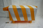
Sculpture: Sheep
Images, Canterbury Museum
One yellow plastic sheep of cuboid shape with reflective stripes around body.
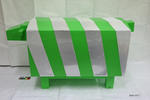
Sculpture: Sheep
Images, Canterbury Museum
One green plastic sheep of cuboid shape with reflective stripes around body.
Animals in Emergencies - Donelle Gadenne
Audio, Radio New Zealand
Cats, dogs, horses, parrots, rats, hedgehogs and turtles. Just like people, these animals were affected by the earthquakes in Christchurch. And two researchers have published a new book into just how big the impact of the September 2010 and February 2011 earthquakes were. 'Animals in Emergencies: Learning from the Christchurch Earthquakes' is co-authored by Canterbury University's associate professor Annie Potts, and former veterinary nurse Donelle Gadenne.
20140112_7511_1D3-195 External Stairway
Images, eqnz.chch.2010
External stairs on the Forsyth Barr building in Christchurch. Portions of the internal stairwell collapsed during the earthquake of February 22nd 2011, necessitating use of various means of getting people out of the building. Was the fourth highest building in the city pre earthquakes, but it's future is uncertain. Was for sale "as is, where ...
Lessons from the 2011 Christchurch earthquake for improving the seismic pe…
Research papers, The University of Auckland Library
The 2011, 6.3 magnitude Christchurch earthquake in New Zealand caused considerable structural damage. It is believed that this event has now resulted in demolition of about 65-70% of the building stock in the Central Business District (CBD), significantly crippling economic activities in the city of Christchurch. A major concern raised from this event was adequacy of the current seismic design practice adopted for reinforced concrete walls due to their poor performance in modern buildings. The relatively short-duration earthquake motion implied that the observed wall damage occurred in a brittle manner despite adopting a ductile design philosophy. This paper presents the lessons learned from the observed wall damage in the context of current state of knowledge in the following areas: concentrating longitudinal reinforcement in wall end regions; determining wall thickness to prevent out-of-plane wall buckling; avoiding lap splices in plastic hinge zones; and quantifying minimum vertical reinforcement. http://www.2eceesistanbul.org/
The Demise of the URM Building Stock in Christchurch during the 2010–2011 …
Research papers, The University of Auckland Library
The progressive damage and subsequent demolition of unreinforced masonry (URM) buildings arising from the Canterbury earthquake sequence is reported. A dataset was compiled of all URM buildings located within the Christchurch CBD, including information on location, building characteristics, and damage levels after each major earthquake in this sequence. A general description of the overall damage and the hazard to both building occupants and to nearby pedestrians due to debris falling from URM buildings is presented with several case study buildings used to describe the accumulation of damage over the earthquake sequence. The benefit of seismic improvement techniques that had been installed to URM buildings is shown by the reduced damage ratios reported for increased levels of retrofit. Demolition statistics for URM buildings in the Christchurch CBD are also reported and discussed. VoR - Version of Record
27 named on the Special Honours List for Bravery Awards
Audio, Radio New Zealand
Some of the men and women who risked their lives to save others in the aftermath of the February 2011 earthquakes in Christchurch have been recognised for their bravery.
Housing affordability in post-earthquake Christchurch
Research papers, Lincoln University
"Prior to the devastating 2010-2011 Canterbury earthquakes, the city of Christchurch was already exhibiting signs of a housing affordability crisis. The causes and symptoms were similar to those being experienced in Auckland, but the substantial damage to the housing stock caused by the earthquakes added new dimensions and impetus to the problem. Large swathes of the most affordable housing stock in the east of the city were effectively destroyed by the earthquakes. In itself this would have pushed the mean house price upwards, but compounding problems exacerbated the situation. These include the price effects of reduced supply of both rented and owned housing and increased demand from both displaced residents and an influx of rebuild workers. The need for additional temporary housing while repairs were undertaken and the associated insurance pay-outs bidding up rents with improved rental returns leading to increased interest in property investment. Land supply constraints and consenting issues inhibiting the build of new housing and political infighting and uncertainty regarding the future of parts of the city leading to a flight of development activity to peripheral locations and adjoining local authorities. Concerns that the erosion of the city council rating base combined with inadequacy of insurance cover for infrastructure will lead to large rates increases, increased development costs and reduced amenities and services in future years. These and other issuers will be elaborated on in this paper with a view to exploring the way forward for affordable housing Christchurch City."
Focus on Politics for 18 July 2014
Audio, Radio New Zealand
Christchurch and its surrounding towns are slowly starting to be rebuilt after the devastating earthquakes of 2010 and 2011. Our political editor Brent Edwards has been in Christchurch to find out whether the rebuild debate will dominate the election campaign in the city.
Select liquefaction case histories from the 2010-2011 Canterbury earthquak…
Research papers, University of Canterbury Library
The 2010–2011 Canterbury earthquake sequence began with the 4 September 2010, Mw7.1 Darfield earthquake and includes up to ten events that induced liquefaction. Most notably, widespread liquefaction was induced by the Darfield and Mw6.2 Christchurch earthquakes. The combination of well-documented liquefaction response during multiple events, densely recorded ground motions for the events, and detailed subsurface characterization provides an unprecedented opportunity to add well-documented case histories to the liquefaction database. This paper presents and applies 50 high-quality cone penetration test (CPT) liquefaction case histories to evaluate three commonly used, deterministic, CPT-based simplified liquefaction evaluation procedures. While all the procedures predicted the majority of the cases correctly, the procedure proposed by Idriss and Boulanger (2008) results in the lowest error index for the case histories analyzed, thus indicating better predictions of the observed liquefaction response.
Remembering...
Images, eqnz.chch.2010
None
Urban Disaster Recovery in Christchurch: The Central Business District Cor…
Research papers, University of Canterbury Library
Copyright 2014. Earthquake Engineering Research Institute. This article may be downloaded for personal use only. Any other use requires prior permission of the Earthquake Engineering Research Institute.The Canterbury earthquakes, which involved widespread damage in the February 2011 event and ongoing aftershocks near the Christchurch central business district (CBD), presented decision-makers with many recovery challenges. This paper identifies major government decisions, challenges, and lessons in the early recovery of Christchurch based on 23 key-informant interviews conducted 15 months after the February 2011 earthquake. It then focuses on one of the most important decisions – maintaining the cordon around the heavily damaged CBD – and investigates its impacts. The cordon displaced 50,000 central city jobs, raised questions about (and provided new opportunities for) the long-term viability of downtown, influenced the number and practice of building demolitions, and affected debris management; despite being associated with substantial losses, the cordon was commonly viewed as necessary, and provided some benefits in facilitating recovery. Management of the cordon poses important lessons for planning for catastrophic urban earthquakes around the world.
Emails show Worksafe not on top of asbestos until 2013
Audio, Radio New Zealand
Documents obtained by Radio New Zealand show WorkSafe New Zealand was still grappling to get on top of asbestos dangers in the Christchurch rebuild nearly two years after the February 2011 earthquake.
Good Coconuts
Audio, Radio New Zealand
Professional and personal partners Victoria Flight and John Drew about the nutritional benefits of coconut oil, and the decision to develop their business 'Blue Coconut' after experiencing a deeply traumatic event in Christchurch's earthquake of February 2011.
The landscape record of blind fault earthquakes
Research papers, University of Canterbury Library
Active faults capable of generating highly damaging earthquakes may not cause surface rupture (i.e., blind faults) or cause surface ruptures that evade detection due to subsequent burial or erosion by surface processes. Fault populations and earthquake frequency-‐magnitude distributions adhere to power laws, implying that faults too small to cause surface rupture but large enough to cause localized strong ground shaking densely populate continental crust. The rupture of blind, previously undetected faults beneath Christchurch, New Zealand in a suite of earthquakes in 2010 and 2011, including the fatal 22 February 2011 moment magnitude (Mw) 6.2 Christchurch earthquake and other large aftershocks, caused a variety of environmental impacts, including major rockfall, severe liquefaction, and differential surface uplift and subsidence. All of these effects occurred where geologic evidence for penultimate effects of the same nature existed. To what extent could the geologic record have been used to infer the presence of proximal, blind and / or unidentified faults near Christchurch? In this instance, we argue that phenomena induced by high intensity shaking, such as rock fragmentation and rockfall, revealed the presence of proximal active faults in the Christchurch area prior to the recent earthquake sequence. Development of robust earthquake shaking proxy datasets should become a higher scientific priority, particularly in populated regions.
20141005_2502_1D3-40 CTV site
Images, eqnz.chch.2010
The sign reads: The CTV Building was headquarters of Canterbury Television (CTV) and also housed King’s Education language School, a medical clinic, Hair Consultants, Relationship Services and a nursing school. On February 22nd 2011 the building collapsed as a result of a major earthquake. Sadly, 115 people who were in the building lost their l...
Performance of horizontal infrastructure in Christchurch city through the …
Research papers, University of Canterbury Library
This is an interim report from the research study performed within the NHRP Research Project “Impacts of soil liquefaction on land, buildings and buried pipe networks: geotechnical evaluation and design, Project 3: Seismic assessment and design of pipe networks in liquefiable soils”. The work presented herein is a continuation of the comprehensive study on the impacts of Christchurch earthquakes on the buried pipe networks presented in Cubrinovski et al. (2011). This report summarises the performance of Christchurch City’s potable water, waste water and road networks through the 2010-2011 Canterbury Earthquake Sequence (CES), and particularly focuses on the potable water network. It combines evidence based on comprehensive and well-documented data on the damage to the water network, detailed observations and interpretation of liquefaction-induced land damage, records and interpretations of ground motion characteristics induced by the Canterbury earthquakes, for a network analysis and pipeline performance evaluation using a GIS platform. The study addresses a range of issues relevant in the assessment of buried networks in areas affected by strong earthquakes and soil liquefaction. It discusses performance of different pipe materials (modern flexible pipelines and older brittle pipelines) including effects of pipe diameters, fittings and pipeline components/details, trench backfill characteristics, and severity of liquefaction. Detailed breakdown of key factors contributing to the damage to buried pipes is given with reference to the above and other relevant parameters. Particular attention is given to the interpretation, analysis and modelling of liquefaction effects on the damage and performance of the buried pipe networks. Clear link between liquefaction severity and damage rate for the pipeline has been observed with an increasing damage rate seen with increasing liquefaction severity. The approach taken here was to correlate the pipeline damage to LRI (Liquefaction Resistance Index, newly developed parameter in Cubrinovski et al., 2011) which represents a direct measure for the soil resistance to liquefaction while accounting for the seismic demand through PGA. Key quality of the adopted approach is that it provides a general methodology that in conjunction with conventional methods for liquefaction evaluation can be applied elsewhere in New Zealand and internationally. Preliminary correlations between pipeline damage (breaks km-1), liquefaction resistance (LRI) and seismic demand (PGA) have been developed for AC pipes, as an example. Such correlations can be directly used in the design and assessment of pipes in seismic areas both in liquefiable and non-liquefiable areas. Preliminary findings on the key factors for the damage to the potable water pipe network and established empirical correlations are presented including an overview of the damage to the waste water and road networks but with substantially less detail. A comprehensive summary of the damage data on the buried pipelines is given in a series of appendices.
Soft Sculpture Kakapo: Little Ra
Images, Canterbury Museum
One green and yellow soft sculpture kakapo with wire feet, stuffed body and black plastic eyes. Has an attached card naming the bird Little Ra and explaining it is part of the 'Journey - The Kakapo of Christchurch' project by artist Sayraphim Lothian.
Firefighter's efforts in CTV rescue recognised
Audio, Radio New Zealand
Twenty seven men and women who risked their lives to save others after the February 2011 earthquake in Christchurch have been recognised for their bravery. Joining us is a Christchurch firefighter, Paul Rodwell, one of the first on scene at the CTV building and who has been awarded a medal in the awards.
Key factors in the liquefaction-induced damage to buildings and infrastruc…
Research papers, University of Canterbury Library
The paper presents preliminary findings from comprehensive research studies on the liquefaction-induced damage to buildings and infrastructure in Christchurch during the 2010-2011 Canterbury earthquakes. It identifies key factors and mechanisms of damage to road bridges, shallow foundations of CBD buildings and buried pipelines, and highlights the implications of the findings for the seismic analysis and design of these structures.
Performance of the Christchurch, New Zealand cathedral during the M7.1 201…
Research papers, The University of Auckland Library
The Catholic Cathedral is classified as a category 1 listed heritage building constructed largely of unreinforced stone masonry, and was significantly damaged in the recent Canterbury earthquakes of 2010 and 2011. In the 2010 event the building presented slight to moderta damage, meanwhile in the 2011 one experienced ground shaking in excess of its capacity leading to block failures and partial collapse of parts of the building, which left the building standing but still posing a significant hazard. In this paper we discuss the approach to develop the earthquake analysis of the building by 3D numerical simulations, and the results are compared/calibrated with the observed damage of the 2010 earthquake. Very accurate records were obtained during both earthquakes due to a record station located least than 80 m of distance from the building and used in the simulations. Moreover it is included in the model the soil structure interaction because it was observed that the ground and foundation played an important role on the seismic behavior of the structure. A very good agreement was found between the real observed damage and the nonlinear dynamic simulations described trough inelastic deformation (cracking) and building´s performance.
Post-disaster geotechnical response for hilly terrain: a case study from t…
Research papers, University of Canterbury Library
Case study analysis of the 2010-2011 Canterbury Earthquake Sequence (CES), which particularly impacted Christchurch City, New Zealand, has highlighted the value of practical, standardised and coordinated post-earthquake geotechnical response guidelines for earthquake-induced landslides in urban areas. The 22nd February 2011 earthquake, the second largest magnitude event in the CES, initiated a series of rockfall, cliff collapse and loess failures around the Port Hills which severely impacted the south-eastern part of Christchurch. The extensive slope failure induced by the 22nd February 200 earthquake was unprecedented; and ground motions experienced significantly exceeded the probabilistic seismic hazard model for Canterbury. Earthquake-induced landslides initiated by the 22nd February 2011 earthquake posed risk to life safety, and caused widespread damage to dwellings and critical infrastructure. In the immediate aftermath of the 22nd February 2011 earthquake, the geotechnical community responded by deploying into the Port Hills to conduct assessment of slope failure hazards and life safety risk. Coordination within the voluntary geotechnical response group evolved rapidly within the first week post-earthquake. The lack of pre-event planning to guide coordinated geotechnical response hindered the execution of timely and transparent management of life safety risk from coseismic landslides in the initial week after the earthquake. Semi-structured interviews were conducted with municipal, management and operational organisations involved in the geotechnical response during the CES. Analysis of interview dialogue highlighted the temporal evolution of priorities and tasks during emergency response to coseismic slope failure, which was further developed into a phased conceptual model to inform future geotechnical response. Review of geotechnical responses to selected historical earthquakes (Northridge, 1994; Chi-Chi, 1999; Wenchuan, 2008) has enabled comparison between international practice and local response strategies, and has emphasised the value of pre-earthquake preparation, indicating the importance of integration of geotechnical response within national emergency management plans. Furthermore, analysis of the CES and international earthquakes has informed pragmatic recommendations for future response to coseismic slope failure. Recommendations for future response to earthquake-induced landslides presented in this thesis include: the integration of post-earthquake geotechnical response with national Civil Defence and Emergency Management; pre-earthquake development of an adaptive management structure and standard slope assessment format for geotechnical response; and emergency management training for geotechnical professionals. Post-earthquake response recommendations include the development of geographic sectors within the area impacted by coseismic slope failure, and the development of a GIS database for analysis and management of data collected during ground reconnaissance. Recommendations provided in this thesis aim to inform development of national guidelines for geotechnical response to earthquake-induced landslides in New Zealand, and prompt debate concerning international best practice.
20140522_8951_EOS M-22 Demolition
Images, eqnz.chch.2010
20140522_8951_EOS M-22 Demolition Of what many in Christchurch know as the Millers building, but for many recent years was the home to the Christchurch City Council, till just a week or two before the first earthquake of 2010. Now, in mid-2014 it is finally being demolished after nearly 45 months empty. A bus is leaving the new (temporary) bu...
Quake aftermath: Christchurch journalists' collective trauma experience an…
Research papers, University of Canterbury Library
On February 22, 2011, Christchurch-based journalists were jolted out of their normal work routine by a large 6.3 magnitude earthquake that killed 185 people, wrecked the city and forced reporters to reappraise their journalism. This study considers how the earthquake affected journalists’ relationship to the community, their use of sources and news selection. A theory of collective trauma is used to explain the changes that journalists made to their reporting practice. Specifically, Christchurch journalists had a greater identification and attachment to their audience post-earthquake. Journalists viewed themselves as part of the earthquake story, which prompted them to view sources differently, use those sources differently and see advocacy as a keystone of their news work after the disaster. This study adds to a growing scholarship about journalists and trauma, but focuses on what the event meant for local reporters’ choice of sources and news selection rather than measuring rates of psychological distress.
Neil Cox: Christchurch Theatre Royal CEO
Audio, Radio New Zealand
Christchurch's historic Theatre Royal will reopen for business in November, with bookings about to open for the first show, the Royal New Zealand Ballet season of "A Christmas Carol" The 106-year old theatre has been closed for almost four years because of earthquake damage in the 2010 and 2011 earthquakes. The $40million rebuild and restoration project will be completed over the next five months and on 17 November 2014, the 'Grand Old Lady' of New Zealand theatre will reopen her doors for performances. With so few venues for performance left in the city, including the Town Hall out of commission indefinitely, the rebuild of the Theatre Royal is very good news for Christchurch audiences Chief executive Neil Cox explains the process of getting oldest Edwardian theatre in the country back in use and mounting the large scale theatrical productions it has been famous for.