Search
found 73 results
Images for 2010; more images...


20160104_1608_7D2-20 Porritt Park (004/366)
Images, eqnz.chch.2010
Porritt Park was, before the earthquakes, the headquarters of hockey in this region. Two astro-turf fields (the main one was other side of the building), and corporate offices etc. The earthquakes buckled all the playing surfaces and damaged the buildings; a couple of smaller ones have been removed. Hockey shifted the other side of the city t...
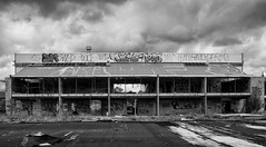
Porritt Park
Images, eqnz.chch.2010
20160104_1602_7D2-20 Porritt Park Porritt Park was, before the earthquakes, the headquarters of hockey in this region. Two astro-turf fields (the main one was to the left of the building), and corporate offices etc. The earthquakes buckled all the playing surfaces and damaged the buildings; a couple of smaller ones have been removed. Hocke...
Red Zone Closures
Images, eqnz.chch.2010
20160415_0029_1D3-24 Red Zone Closures The permanent closure (to motor vehicles) of the Bexley red zone streets has started. This was once the main south-north route just west of the Avon River in the New Brighton area, till an expressway (ring road) was built about 80m to the west (right) about 12-13 years ago. Then it became just another ...
20160307_6607_7D2-110 Interior removal
Images, eqnz.chch.2010
The Forsyth Barr building has stood silent and empty (except the occasional intruder and pigeons) since the February 2011 earthquake. It was sold "as is" and I understand that it is now going to be fitted out as a hotel. This is the building that had severe stairwell damage during the quake necessitating people being lowered via ropes etc on t...
The Wobbly Jetty - 1 (106/366) [Explored]
Images, eqnz.chch.2010
20160415_0039_1D3-40 The Wobbly Jetty - 1 (106/366) [Explored] The South New Brighton jetty was rebuilt a couple of years before the 2010 and 2011 earthquakes wrecked it. Then, it was straight, level and all railings on left side were intact. Was closed to the public for about four years but is open now. #7221
20160307_6619_7D2-125 Covering up
Images, eqnz.chch.2010
One of the most beautiful pieces of wall art (added to the blank walls after buildings were demolished following the earthquakes) in Christchurch, is now being hidden by a new building in front of it. www.flickr.com/photos/johnstewartnz/15499321681/in/...
20160307_0036_EOS M-41 Summit Road closed
Images, eqnz.chch.2010
None
The Wobbly Jetty - 2
Images, eqnz.chch.2010
20160415_0044_1D3-38 The Wobbly Jetty - 2 The South New Brighton jetty was rebuilt a couple of years before the earthquakes wrecked it. Was closed to the public for about four years but is open now. #7222
20160307_0012_1D3-32 Subway is closed (067/366)
Images, eqnz.chch.2010
20160307_0012_1D3-32 Subway is closed (067/366) The Subway shop in the High Street Mall has not operated since lunch time on the 22nd February 2011 when the most damaging of Christchurch and Canterbury's earthquakes struck. I assume the building is still to be demolished. #7119
20160307_6634_7D2-82 Really Wild!
Images, eqnz.chch.2010
A section of retaining wall that tilted in the Christchurch 2011 earthquake. At the Edmunds Band Rotunda sight. Still not repaired,
20160307_6626_7D2-200 Pigeon City
Images, eqnz.chch.2010
Pigeons sit on the remains of one of the tallest buildings in Christchurch that was 95% demolished two or three years ago. The basement (now filled with water) and the columns remain. Demolished due to damage from the Christchurch 2011 earthquake.
20160419_7732_7D2-400 The City is in Rebuild phase (110/366)
Images, eqnz.chch.2010
20160419_7732_7D2-400 The City is in Rebuild phase (110/366) A totally different view to a few years ago. Most of the tall buildings have gone and construction is underway on a lot of new buildings, View from across the Estuary in Redcliffs. A couple of days ago the government agency controlling the post-earthquake work (CERA - Canterbury Ea...
20160703_144759_GT-S7275T-04 New sea wall at Redcliffs (185/366)
Images, eqnz.chch.2010
20160703_144759_GT-S7275T-04 New sea wall at Redcliffs (185/366) I went for a drive in my second car mainly to charge the battery up and forgot to take my camera gear so only had my phone. This is the new rock wall to replace the severely damaged previous one (in the February 2011 earthquake). Work is still underway on the car parking and p...
20160612_8429_1D3-40 Abandoned and maybe forgotten
Images, eqnz.chch.2010
AMI Stadium (Lancaster Park), not used since the February 2011 earthquake. It was used predominantly for rugby and cricket. We are still waiting to see what the outcome is for this stadium. Government want a new one closer to the CBD, so there is talk of this being demolished, while others want it repaired. The concrete pad lower left is ...
20160613_0044_7D2-100 Jetty Closed
Images, eqnz.chch.2010
The South New Brighton jetty has been closed for 3 or 4 years (fenced off) then the fence was removed and it was "open", but nothing has happened to it since the earthquakes, but it is closed again now, although it looks like a home made sign!
20160612_8434_1D3-40 Ticket Sales (164/366)
Images, eqnz.chch.2010
The ticket office at Lancaster Park (AMI Stadium), not used since the February 2011 earthquake. Windows broken and door boarded up. We are still waiting to see what the outcome is for this stadium. Government want a new one closer to the CBD, so there is talk of this being demolished, while others want it repaired.
20161018_9063_7D2-70 Restricted Area (292/366)
Images, eqnz.chch.2010
20161018_9063_7D2-70 Restricted Area (292/366) In the suburban red zone on Avonside Drive. #7826
20161112_9965_7D2-24 Another view of part of the Cultivate Christchurch in…
Images, eqnz.chch.2010
None
The future face of Christchurch?
Images, eqnz.chch.2010
20161112_9961_7D2-70 The future face of Christchurch? Cultivate Christchurch is operating this urban farm in the city, about 5-10 minutes walk to Cathedral Square. Many of the buildings in this area were demolished after the earhquakes, and in the background is a new building on Kilmore Street.
Six years on
Images, eqnz.chch.2010
20161211_0216_1D3-24 Six years on A view that was impossible six years ago. There was a group of buildings including another high-rise in the vacant area in the middle ground. #7986
Liquefaction-induced lateral spreading in the 2010-2011 Canterbury earthqu…
Research papers, University of Canterbury Library
Liquefaction-induced lateral spreading in large seismic events often results in pervasive and costly damage to engineering structures and lifelines, making it a critical component of engineering design. However, the complex nature of this phenomenon leads to designing for such a hazard extremely challenging and there is a clear for an improved understanding and predicting liquefaction-induced lateral spreading. The 2010-2011 Canterbury (New Zealand) Earthquakes triggered severe liquefaction-induced lateral spreading along the streams and rivers of the Christchurch region, causing extensive damage to roads, bridges, lifelines, and structures in the vicinity. The unfortunate devastation induced from lateral spreading in these events also rendered the rare opportunity to gain an improved understanding of lateral spreading displacements specific to the Christchurch region. As part of this thesis, the method of ground surveying was employed following the 4 September 2010 Darfield (Mw 7.1) and 22 February 2011 Christchurch (Mw 6.2) earthquakes at 126 locations (19 repeated) throughout Christchurch and surrounding suburbs. The method involved measurements and then summation of crack widths along a specific alignment (transect) running approximately perpendicular to the waterway to indicate typically a maximum lateral displacement at the bank and reduction of the magnitude of displacements with distance from the river. Rigorous data processing and comparisons with alternative measurements of lateral spreading were performed to verify results from field observations and validate the method of ground surveying employed, as well as highlight the complex nature of lateral spreading displacements. The welldocumented field data was scrutinized to gain an understanding of typical magnitudes and distribution patterns (distribution of displacement with distance) of lateral spreading observed in the Christchurch area. Maximum displacements ranging from less than 10 cm to over 3.5 m were encountered at the sites surveyed and the area affected by spreading ranged from less than 20 m to over 200 m from the river. Despite the highly non-uniform displacements, four characteristic distribution patterns including large, distributed ground displacements, block-type movements, large and localized ground displacements, and areas of little to no displacements were identified. Available geotechnical, seismic, and topographic data were collated at the ground surveying sites for subsequent analysis of field measurements. Two widely-used empirical models (Zhang et al. (2004), Youd et al. (2002)) were scrutinized and applied to locations in the vicinity of field measurements for comparison with model predictions. The results indicated generally poor correlation (outside a factor of two) with empirical predictions at most locations and further validated the need for an improved, analysis- based method of predicting lateral displacements that considers the many factors involved on a site-specific basis. In addition, the development of appropriate model input parameters for the Youd et al. (2002) model led to a site-specific correlation of soil behavior type index, Ic, and fines content, FC, for sites along the Avon River in Christchurch that matched up well with existing Ic – FC relationships commonly used in current practice. Lastly, a rigorous analysis was performed for 25 selected locations of ground surveying measurements along the Avon River where ground slope conditions are mild (-1 to 2%) and channel heights range from about 2 – 4.5 m. The field data was divided into categories based on the observed distribution pattern of ground displacements including: large and distributed, moderate and distributed, small to negligible, and large and localized. A systematic approach was applied to determine potential critical layers contributing to the observed displacement patterns which led to the development of characteristic profiles for each category considered. The results of these analyses outline an alternative approach to the evaluation of lateral spreading in which a detailed geotechnical analysis is used to identify the potential for large spreading displacements and likely spatial distribution patterns of spreading. Key factors affecting the observed magnitude and distribution of spreading included the thickness of the critical layer, relative density, soil type and layer continuity. It was found that the large and distributed ground displacements were associated with a thick (1.5 – 2.5 m) deposit of loose, fine to silty sand (qc1 ~4-7 MPa, Ic 1.9-2.1, qc1n_cs ~50-70) that was continuous along the bank and with distance from the river. In contrast, small to negligible displacements were characterized by an absence of or relatively thin (< 1 m), discontinuous critical layer. Characteristic features of the moderate and distributed displacements were found to be somewhere between these two extremes. The localized and large displacements showed a characteristic critical layer similar to that observed in the large and distributed sites but that was not continuous and hence leading to the localized zone of displacement. The findings presented in this thesis illustrate the highly complex nature of lateral displacements that cannot be captured in simplified models but require a robust geotechnical analysis similar to that performed for this research.
Christchurch Natural Disaster Response and Recovery presentation
Articles, UC QuakeStudies
A pdf copy of a PowerPoint presentation made for the Water Services Association of Australia conference, about SCIRT's approach to asset investigation after the Canterbury earthquakes of 2010 and 2011.
Broadband ground motion simulation of the 2010-2011 Canterbury earthquake …
Research papers, University of Canterbury Library
In this paper, we perform hybrid broadband (0-10 Hz) ground motion simulations for the ten most significant events (Mw 4.7-7.1) in the 2010-2011 Canterbury earthquake sequence. Taking advantage of having repeated recordings at same stations, we validate our simulations using both recordings and an empirically-developed ground motion prediction equation (GMPE). The simulation clearly captures the sedimentary basin amplification and the rupture directivity effects. Quantitative comparisons of the simulations with both recordings and the GMPE, as well as analyses of the total residuals (indicating model bias) show that simulations perform better than the empirical GMPE, especially for long period. To scrutinize the ground motion variability, we partitioned the total residuals into different components. The total residual appears to be unbiased, and the use of a 3D velocity structure reduces the long period systematic bias particularly for stations located close to the Banks Peninsula volcanic area.
A Case Study of Successful Performance of Retrofitted Masonry Substations
Research papers, University of Canterbury Library
Since the mid 1990s, the Christchurch inventory of substation buildings was seismically retrofitted as part of the Risk and Realities improvement programme. • The substation buildings were retrofitted using a system of simple and cost-effective steel elements. • The 2010/2011 Canterbury earthquakes caused significant immediate disruption to power distribution network in Christchurch. • It took a single day in September 2010 and ten days in February 2011 to restore power to 90% customers. Tostudytheseismicperformanceofmasonrysubstationbuildingsfromamulti-disciplinary perspective on structural,economic and social aspects.
Systematic vertical ground motion observations in the Canterbury earthquak…
Research papers, University of Canterbury Library
The 2010-2011 Canterbury earthquake sequence was extremely damaging to structures in Christchurch and continues to have a large economic and social impact on the city and surrounding regions. In addition to strong ground shaking (Bradley and Cubrinovski 2011 SRL; Bradley 2012 SDEE), extensive liquefaction was observed, particularly in the 4 September 2010 Darfield earthquake and the 22 February 2011 Christchurch earthquake (Cubrinovski et al. 2010 BNZSEE; 2011 SRL). Large observed vertical ground motion amplitudes were recorded in the events in this sequence, with vertical peak ground accelerations of over 2.2g being observed at the Heathcote Valley Primary School during the Christchurch earthquake, and numerous other vertical motions exceeding 1.0g (Bradley and Cubrinovski 2011 SRL; Bradley 2012 SDEE; Fry et al 2011 SRL). Vertical peak ground accelerations of over 1.2g were observed in the Darfield earthquake.
People in Disasters Conference - Canterbury Primary Care Response to Earth…
Videos, UC QuakeStudies
A video of a presentation by Dr Phil Schroeder, Managing Director of Rolleston Central Health, during the second plenary of the 2016 People in Disasters Conference. The presentation is titled, "Canterbury Primary Care Response to Earthquakes in 2010/2011".
Simulation of site amplification effects at Heathcote Valley during the 20…
Research papers, University of Canterbury Library
Heathcote Valley school strong motion station (HVSC) consistently recorded ground motions with higher intensities than nearby stations during the 2010-2011 Canterbury earthquakes. For example, as shown in Figure 1, for the 22 February 2011 Christchurch earthquake, peak ground acceleration at HVSC reached 1.4 g (horizontal) and 2 g (vertical), the largest ever recorded in New Zealand. Strong amplification of ground motions is expected at Heathcote Valley due to: 1) the high impedance contrast at the soil-rock interface, and 2) the interference of incident and surface waves within the valley. However, both conventional empirical ground motion prediction equations (GMPE) and the physics-based large scale ground motions simulations (with empirical site response) are ineffective in predicting such amplification due to their respective inherent limitations.
Community amenity, social connectedness and resilience: the informal respo…
Research papers, University of Canterbury Library
The characteristics of the local environment such as access to community amenity and facilities and their impact on health and wellbeing have been well researched. The question is can local amenity confer similar benefits to help facilitate community resilience? Research following the Christchurch, New Zealand February 22nd 2011 earthquake has shown that socially connected communities were able to respond and adapt with collective action. The informal community response was important in supporting residents until infrastructure and more formal structures could be put in place. This research provides support to the importance of social connectedness prior to a disaster to help foster community resilience. It discusses the role of local infrastructure such as shops, local pubs and community amenity in providing gathering places for people to meet and interact and share information. It shows that geographically defined communities with central meeting places were able to use social connections and from this collective action as support. Resilience is a by-product of having good social connections and community amenity helps to facilitate those connections.
Post-disaster indigenous mental health support: Tangata whaiora networks a…
Research papers, Lincoln University
This paper identifies and analyses the networks of support for tangata whaiora (mental health clients) utilising a kaupapa Mäori health service following the Ötautahi/Christchurch earthquakes in Aotearoa New Zealand from 2010 to 2012. Semi- structured interviews were undertaken with 39 participants, comprising clients (Mäori and Päkehä), staff, managers and board members of a kaupapa Mäori provider in the city. Selected quotes are presented alongside a social network analysis of the support accessed by all participants. Results show the signifi cant isolation of both Mäori and Päkehä mental health clients post- disaster and the complexity of individuals and collectives dealing with temporally and spatially overlapping hazards and disasters at personal, whänau and community level.
Hybrid Broadband Ground Motion Simulations of Porters Pass Earthquakes
Research papers, University of Canterbury Library
We present ground motion simulations of the Porters Pass (PP) fault in the Canterbury region of New Zealand; a major active source near Christchurch city. The active segment of the PP fault has an inferred length of 82 km and a mostly strike-slip sense of movement. The PP fault slip makes up approximately 10% of the total 37 mm/yr margin-parallel plate motion and also comprises a significant proportion of the total strain budget in regional tectonics. Given that the closest segment of the fault is less than 45 km from Christchurch city, the PP fault is crucial for accurate earthquake hazard assessment for this major population centre. We have employed the hybrid simulation methodology of Graves and Pitarka (2010, 2015), which combines low (f<1 Hz) and high (f>1 Hz) frequencies into a broadband spectrum. We have used validations from three moderate magnitude events (𝑀𝑤4.6 Sept 04, 2010; 𝑀𝑤4.6 Nov 06, 2010; 𝑀𝑤4.9 Apr 29, 2011) to build confidence for the 𝑀𝑤 > 7 PP simulations. Thus far, our simulations include multiple rupture scenarios which test the impacts of hypocentre location and the finite-fault stochastic rupture representation of the source itself. In particular, we have identified the need to use location-specific 1D 𝑉𝑠/𝑉𝑝 models for the high frequency part of the simulations to better match observations.