Search
Images for Richter; more images...
IMG_2400
Images, eqnz.chch.2010
Damaged rose window of the St John the Baptist Church at Latimer Square; aftermath of the magnitude 7.1 earthquake that struck Christchurch on Saturday 4 September 2010.
IMG_2224
Images, eqnz.chch.2010
Toppled grain silos on the outskirts of Darfield near the epicentre of the magnitude 7,1 earthquake that struck on Saturday 4 September 2010.
IMG_2226
Images, eqnz.chch.2010
Toppled grain silos on the outskirts of Darfield near the epicentre of the magnitude 7,1 earthquake that struck on Saturday 4 September 2010.
MVI_2430
Videos, eqnz.chch.2010
At Greendale Faultline on Highfield Road in mid-Canterbury, where the magnitude 7.1 earthquake on 4 September 2010 originated.
IMG_2465
Images, eqnz.chch.2010
Repairs being carried out on this restaurant (converted from a church) at the Hereford Street / Manchester Street intersection;aftermath of the magnitude 7.1 earthquake that struck Christchurch on Saturday 4 September 2010.
IMG_2233
Images, eqnz.chch.2010
Heaving and subsidence on the faultline left scars where the magnitude 7.1 earthquake on Saturday 4 September 2010 originated.
IMG_2223
Images, eqnz.chch.2010
Toppled grain silos on the outskirts of Darfield near the epicentre of the magnitude 7,1 earthquake that struck on Saturday 4 September 2010.
IMG_2221
Images, eqnz.chch.2010
Toppled grain silos on the outskirts of Darfield near the epicentre of the magnitude 7,1 earthquake that struck on Saturday 4 September 2010.
IMG_2229
Images, eqnz.chch.2010
Toppled grain silos on the outskirts of Darfield near the epicentre of the magnitude 7,1 earthquake that struck on Saturday 4 September 2010.
IMG_2220
Images, eqnz.chch.2010
Toppled grain silos on the outskirts of Darfield near the epicentre of the magnitude 7,1 earthquake that struck on Saturday 4 September 2010.
IMG_2246
Images, eqnz.chch.2010
The latest (but temporary) tourist attraction in mid-Canterbury! This was the previously unknown faultline where the Saturday 4 September 2010 earthquake originated.
MVI_2425
Videos, eqnz.chch.2010
At Greendale Faultline on Highfield Road in mid-Canterbury, where the magnitude 7.1 earthquake on 4 September 2010 originated.
MVI_2424
Videos, eqnz.chch.2010
At Greendale Faultline on Highfield Road in mid-Canterbury, where the magnitude 7.1 earthquake on 4 September 2010 originated.
IMG_2227
Images, eqnz.chch.2010
Toppled grain silos on the outskirts of Darfield near the epicentre of the magnitude 7,1 earthquake that struck on Saturday 4 September 2010.
IMG_2257
Images, eqnz.chch.2010
Tension cracks at least 300 mm deep, on the previously unknown faultline from which the Saturday 4 September 2010 earthquake originated.
IMG_2187
Images, eqnz.chch.2010
This beautiful building on Madras Street is red stickered and may be condemned if the structural damage it suffered in the magnitude 7,1 earthquake on Saturday 4 September 2010 cannot be repaired.
IMG_2228
Images, eqnz.chch.2010
Toppled grain silos on the outskirts of Darfield near the epicentre of the magnitude 7,1 earthquake that struck on Saturday 4 September 2010.
IMG_2186
Images, eqnz.chch.2010
This beautiful building on Madras Street is red stickered and may be condemned if the structural damage it suffered in the magnitude 7,1 earthquake on Saturday 4 September 2010 cannot be repaired.
IMG_2219
Images, eqnz.chch.2010
On the way to Darfield to locate the faultline where the tectonic plates slipped, causing the magnitude 7.1 earthquake on Saturday 4 September 2010.
IMG_2185
Images, eqnz.chch.2010
This beautiful building on Madras Street is red stickered and may be condemned if the structural damage it suffered in the magnitude 7,1 earthquake on Saturday 4 September 2010 cannot be repaired.
IMG_2245
Images, eqnz.chch.2010
Looking across the faultline where the Saturday 4 September 2010 magnitude 7.1 earthquake originated. Note how much the previously straight fence is now out of alignment.
IMG_2404
Images, eqnz.chch.2010
The historic Provincial Hotel at the Barbadoes Street / Cashel Street corner has been cordoned off for fear of collapse; aftermath of the magnitude 7.1 earthquake that struck Christchurch on Saturday 4 September 2010.
IMG_2241
Images, eqnz.chch.2010
Looking across the faultline where the Saturday 4 September 2010 magnitude 7.1 earthquake originated. Note how much the previously straight fence is now out of alignment.
IMG_2407
Images, eqnz.chch.2010
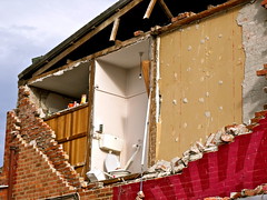
This building at the corner of Barbadoes Street / St Asaph Street was so badly damaged in the magnitude 7.1 earthquake that struck Christchurch on Saturday 4 September 2010 that it had to be demolished
IMG_2254
Images, eqnz.chch.2010
Slipping of the tectonic plates caused tension cracks on this previously unknown faultline that runs through this paddock; magnitude 7.1 earthquake in mid-Canterbury on Saturday 4 September 2010.
IMG_2421
Images, eqnz.chch.2010
Slipping of the tectonic plates caused tension cracks on this previously unknown faultline that runs through this paddock; magnitude 7.1 earthquake in mid-Canterbury on Saturday 4 September 2010.
IMG_2432
Images, eqnz.chch.2010
This originally straight farm fence has been laterally displaced at least 2 metres where it crosses the previously unknown faultline from which the Saturday 4 September 2010 earthquake originated.
IMG_2437
Images, eqnz.chch.2010
This originally straight farm fence has been laterally displaced at least 2 metres where it crosses the previously unknown Greendale Faultline from which the Saturday 4 September 2010 earthquake originated.
IMG_2443
Images, eqnz.chch.2010
The faultline cuts across Telegraph Road, leaving a kink in its originally straight alignment; aftermath of the magnitude 7.1 earthquake in mid-Canterbury on Saturday 4 September 2010.
IMG_2393
Images, eqnz.chch.2010
Efforts are being made to shore up and strengthen this building (corner of Hereford Street / Manchester Street) to save it from demolition after it suffered structural damage in the magnitude 7.1 earthquake that struck Christchurch on Saturday 4 September 2010.


