Search
found 241 results
Images for [empty query]; more images...


Multi-Hazard Analysis: Gap Analysis ReportLDRP97 Multi-Hazard Analysis: Ga…
Research papers, University of Canterbury Library
Christchurch City Council (Council) is undertaking the Land Drainage Recovery Programme in order to assess the effects of the earthquakes on flood risk to Christchurch. In the course of these investigations it has become better understood that floodplain management should be considered in a multi natural hazards context. Council have therefore engaged the Jacobs, Beca, University of Canterbury, and HR Wallingford project team to investigate the multihazards in eastern areas of Christchurch and develop flood management options which also consider other natural hazards in that context (i.e. how other hazards contribute to flooding both through temporal and spatial coincidence). The study has three stages: Stage 1 Gap Analysis – assessment of information known, identification of gaps and studies required to fill the gaps. Stage 2 Hazard Studies – a gap filling stage with the studies identified in Stage 1. Stage 3 Collating, Optioneering and Reporting – development of options to manage flood risk. This present report is to document findings of Stage 1 and recommends the studies that should be completed for Stage 2. It has also been important to consider how Stage 3 would be delivered and the gaps are prioritised to provide for this. The level of information available and hazards to consider is extensive; requiring this report to be made up of five parts each identifying individual gaps. A process of identifying information for individual hazards in Christchurch has been undertaken and documented (Part 1) followed by assessing the spatial co-location (Part 2) and probabilistic presence of multi hazards using available information. Part 3 considers multi hazard presence both as a temporal coincidence (e.g. an earthquake and flood occurring at one time) and as a cascade sequence (e.g. earthquake followed by a flood at some point in the future). Council have already undertaken a number of options studies for managing flood risk and these are documented in Part 4. Finally Part 5 provides the Gap Analysis Summary and Recommendations to Council. The key findings of Stage 1 gap analysis are: - The spatial analysis showed eastern Christchurch has a large number of hazards present with only 20% of the study area not being affected by any of the hazards mapped. Over 20% of the study area is exposed to four or more hazards at the frequencies and data available. - The majority of the Residential Red Zone is strongly exposed to multiple hazards, with 86% of the area being exposed to 4 or more hazards, and 24% being exposed to 6 or more hazards. - A wide number of gaps are present; however, prioritisation needs to consider the level of benefit and risks associated with not undertaking the studies. In light of this 10 studies ranging in scale are recommended to be done for the project team to complete the present scope of Stage 3. - Stage 3 will need to consider a number of engineering options to address hazards and compare with policy options; however, Council have not established a consistent policy on managed retreat that can be applied for equal comparison; without which substantial assumptions are required. We recommend Council undertake a study to define a managed retreat framework as an option for the city. - In undertaking Stage 1 with floodplain management as the focal point in a multi hazards context we have identified that Stage 3 requires consideration of options in the context of economics, implementation and residual risk. Presently the scope of work will provide a level of definition for floodplain options; however, this will not be at equal levels of detail for other hazard management options. Therefore, we recommend Council considers undertaking other studies with those key hazards (e.g. Coastal Hazards) as a focal point and identifies the engineering options to address such hazards. Doing so will provide equal levels of information for Council to make an informed and defendable decision on which options are progressed following Stage 3.
Fault rupture patterns during the Mw7.8 2016 Kaikoura Earthquake in the re…
Research papers, University of Canterbury Library
Surface rupture and slip from the Mw 7.8 2016 Kaikōura Earthquake have been mapped in the region between the Leader and Charwell rivers using field mapping and LiDAR data. The eastern Humps, north Leader and Conway-Charwell faults ruptured the ground surface in the study area. The E-NE striking ‘The Humps’ Fault runs along the base of the Mt Stewart range front, appears to dip steeply NW and intersects the NNW-NNE Leader Fault which itself terminates northwards at the NE striking Conway-Charwell Fault. The eastern Humps Fault is up to the NW and accommodates oblique slip with reverse and right lateral displacement. Net slip on ‘The Humps’ Fault is ≤4 m and produced ≤4 m uplift of the Mt Stewart range during the earthquake. The Leader Fault strikes NNW-NNE with dips ranging from ~10° west to 80° east and accommodated ≤4 m net slip comprising left-lateral and up-to-the-west vertical displacement. Like the Humps west of the study area, surface-rupture of the Leader Fault occurred on multiple strands. The complexity of rupture on the Leader Fault is in part due to the occurrence of bedding-parallel slip within the Cretaceous-Cenozoic sequence. Although the Mt Stewart range front is bounded by ‘The Humps’ Fault, in the study area neither this fault nor the Leader Fault were known to have been active before the earthquake. Fieldwork and trenching investigations are ongoing to characterise the geometry, kinematics and paleoseismic history of the mapped active faults.
Authentic collaboration with local communities in post-disaster reconnaiss…
Research papers, University of Canterbury Library
Geological research in the immediate aftermath of the 2016 Kaikōura Earthquake, New Zealand, was necessary due to the importance and perishability of field data. It also reflects a real desire on the part of researchers to contribute not only to immediate scientific understanding but also to the societal recovery effort by enhancing knowledge of the event for the benefit of affected communities, civil defence organizations and regional and national decision makers. This commitment to outreach and engagement is consistent with the recent IAPG statement of Geoethics. More immediately, it was informed by experience of the 2010-2011 Canterbury Earthquake sequence. After that earlier disaster, intense interactions between researchers and various response agencies as well as local communities informed the development and dissemination of a set of ethical guidelines for researchers immediately following the Mw7.8 14 November 2016 Kaikōura Earthquake. In this presentation, I argue that ethical engagement of this kind is the key to gathering high quality research data immediately after the event. Creating trusting and mutually respectful, mutually beneficial relationships is also vital to ongoing engagement to facilitate further “in depth” research in collaboration with communities.
Preliminary geometry and kinematics of multiple surface ruptures during th…
Research papers, University of Canterbury Library
The Mw 7.8 Kaikōura earthquake ruptured ~200 km at the ground surface across the New Zealand plate boundary zone in the northern South Island. This study was conducted in an area of ~600 km2 in the epicentral region where the faults comprise two main non-coplanar sets that strike E-NE and NNE-NW with mainly steep dips (60о-80°). Analysis of the surface rupture using field and LiDAR data provides new information on the dimensions, geometries and kinematics of these faults which was not previously available from pre-earthquake active faults or bedrock structure. The more northerly striking fault set are sub-parallel to basement bedding and accommodated predominantly left-lateral reverse slip with net slips of ~1 and ~5 m for the Stone Jug and Leader faults, respectively. The E-NE striking Conway-Charwell and The Humps faults accrued right-lateral to oblique reverse with net slips of ~2 and ~3 m, respectively. The faults form a hard-linked system dominated by kinematics consistent with the ~260° trend of the relative plate motion vector and the transpressional structures recorded across the plate boundary in the NE South Island. Interaction and intersection of the main fault sets facilitated propagation of the earthquake and transfer of slip northwards across the plate boundary zone.
The continued response of the New Zealand Government to the Canterbury ear…
Research papers, University of Canterbury Library
The Canterbury earthquakes of 2010 and 2011 caused significant damage and disruption to the city of Christchurch, New Zealand. A Royal Commission was established to report on the causes of building failure as a result of the earthquakes as well as look at the legal and best-practice requirements for buildings in New Zealand Central Business Districts. The Royal Commission made 189 recommendations on a variety of matters including managing damaged buildings after an earthquake, the adequacy of building codes and standards, and the processes of seismic assessments of existing buildings to determine their earthquake vulnerability. In response the Ministry of Business, Innovation and Employment, the agency responsible for administering building regulation in New Zealand, established a work programme to assist with the Canterbury rebuild and to implement the lessons learned throughout New Zealand. The five primary work streams in the programme are: • Facilitating the Canterbury Rebuild • Structural Performance and Design Standards • Geotechnical and structural guidance • Existing Building Resilience • Post Disaster Building Management This paper provides more detail on each of the work streams. There has been significant collaboration between the New Zealand Government and the research community, technical societies, and engineering consultants, both within New Zealand and internationally, to deliver the programme and improve the resilience of the New Zealand built environment. This has presented major challenges for an extremely busy industry in the aftermath of the Canterbury earthquakes. The paper identifies the items of work that have been completed and the work that is still in progress at the time of writing.
Are athletes on the right track? The effect of availability of an all-weat…
Research papers, University of Canterbury Library
In February of 2011, an earthquake destroyed the only all-weather athletics track in the city of Christchurch (New Zealand). The track has yet to be replaced, and so since the loss of the track, local Christchurch athletes have only had a grass track for training and preparation for championship events. This paper considers what effect the loss of the training facility has had on the performance of athletes from Christchurch at national championship events. Not surprisingly, the paper finds that there has been a deterioration in the performance in events that are heavily dependent upon the all-weather surface. However, somewhat more surprisingly, the loss of the track appears to have caused a significant improvement in the performance of Christchurch athletes in events that, while on the standard athletics program, are not heavily track dependent.
Experimental validation of a non-contact, non-line of sight displacement s…
Research papers, University of Canterbury Library
This work investigates the possibility of developing a non-contact, non-line of sight sensor to measure interstorey drift through simulation and experimental validation. • The method uses frequency-modulated continuous wave (FMCW) radar to measure displacement. This method is commonly in use in a number of modern applications, including aircraft altimeters and automotive parking sensors. • The technique avoids numerous problems found in contemporary structural health monitoring methods, namely integral drift errors and structural modification requirements. • The smallest achievable detection error in displacement was found to be as low as 0.26%, through simulated against the displacement response of a single degree of freedom structure subject to ground motion excitation. • This was verified during experimentation, when a corner-style reflector was placed on a shake table running ground motion data taken from the 4th September 2010 earthquake in Christchurch. These results confirmed the conclusions drawn from simulation.
Preliminary insights into the fault geometries and kinematics of surface r…
Research papers, University of Canterbury Library
The south Leader Fault (SLF) is a newly documented active structure that ruptured the surface during the Mw 7.8 Kaikoura earthquake. The Leader Fault is a NNE trending oblique left lateral thrust that links the predominantly right lateral ‘The Humps’ and Conway-Charwell faults. The present research uses LiDAR at 0.5 m resolution and field mapping to determine the factors controlling the surface geometries and kinematics of the south Leader Fault ruptures at the ground surface. The SLF zone is up to 2km wide and comprises a series of echelon NE-striking thrusts linked by near-vertical N-S striking faults. The thrusts are upthrown to the west by up to 1 m and dip 35-45°. Thrust slip surfaces are parallel with Cretaceous-Cenozoic bedding and may reflect flexural slip folding. By contrast, the northerly striking faults dip steeply (65° west- 85° east), and accommodate up to 3m of oblique left lateral displacement at the ground surface and displace Cenozoic bedding. Some of the SLF has been mapped in bedrock, although none were known to be active prior to the earthquake or have a strong topographic expression. The complexity of fault rupture and the width of the fault zone appears to reflect the occurrence of faulting and folding at the ground surface during the earthquake.
Post-earthquake decision-making on sewer recovery and the roles of damage …
Research papers, University of Canterbury Library
Decision making on the reinstatement of the Christchurch sewer system after the Canterbury (New Zealand) earthquake sequence in 2010–2011 relied strongly on damage data, in particular closed circuit television (CCTV). This paper documents that process and considers how data can influence decision making. Data are analyzed on 33,000 pipes and 13,000 repairs and renewals. The primary findings are that (1) there should be a threshold of damage per pipe set to make efficient use of CCTV; (2) for those who are estimating potential damage, care must be taken in direct use of repair data without an understanding of the actual damage modes; and (3) a strong correlation was found between the ratio of faults to repairs per pipe and the estimated peak ground velocity. Taken together, the results provide evidence of the extra benefit that damage data can provide over repair data for wastewater networks and may help guide others in the development of appropriate strategies for data collection and wastewater pipe decisions after disasters.
Laying down foundations: reflecting on disaster management planning in mus…
Research papers, University of Canterbury Library
This thesis looks at the protocols museums and galleries adopt for the safeguarding of art, artefacts and cultural heritage. In particular, it analyses these procedures in relation to the 2010 and 2011 earthquakes in Christchurch, and considers how these events shaped the preventative conservation measures in place in museum and gallery institutions. Through gathering, assessing, and comparing this information about Christchurch’s institutions to disaster management best practices in national and international organisations, this thesis gauges the extent to which disaster management was changed in response to the events in Christchurch. This thesis first considers the growth in disaster management as a field, before examining what are considered best practices within this sector. Finally, it looks at specific institutions in Christchurch, including the Christchurch Art Gallery Te Puna o Waiwhetu, Canterbury Museum, and the Air Force Museum of New Zealand.
Fragility functions for buried pipelines in liquefiable soils based on New…
Research papers, University of Canterbury Library
This poster aims to present fragility functions for pipelines buried in liquefaction-prone soils. Existing fragility models used to quantify losses can be based on old data or use complex metrics. Addressing these issues, the proposed functions are based on the Christchurch network and soil and utilizes the Canterbury earthquake sequence (CES) data, partially represented in Figure 1. Figure 1 (a) presents the pipe failure dataset, which describes the date, location and pipe on which failures occurred. Figure 1 (b) shows the simulated ground motion intensity median of the 22nd February 2011 earthquake. To develop the model, the network and soil characteristics have also been utilized
SeisFinder: A web application for extraction of data from computationally-…
Research papers, University of Canterbury Library
SeisFinder is an open-source web service developed by QuakeCoRE and the University of Canterbury, focused on enabling the extraction of output data from computationally intensive earthquake resilience calculations. Currently, SeisFinder allows users to select historical or future events and retrieve ground motion simulation outputs for requested geographical locations. This data can be used as input for other resilience calculations, such as dynamic response history analysis. SeisFinder was developed using Django, a high-level python web framework, and uses a postgreSQL database. Because our large-scale computationally-intensive numerical ground motion simulations produce big data, the actual data is stored in file systems, while the metadata is stored in the database.
Generalised parametric functions and spatial correlations for seismic velo…
Research papers, University of Canterbury Library
Investigation of systematic ground motion effects through ground motion si…
Research papers, University of Canterbury Library
Simulation-based PSHA for the Canterbury region (Cybershake v17.8)
Research papers, University of Canterbury Library
Modeling nonlinear site effects in physics-based ground motion simulation
Research papers, University of Canterbury Library
This study examines the performance of nonlinear total-stress wave-propagation site response analysis for modelling site effects in physics-based ground motion simulations of the 2010-2011 Canterbury, New Zealand earthquake sequence. This approach allows for explicit modeling of 3-dimensional ground motion phenomena at the regional scale, as well as detailed site effects and soil nonlinearity at the local scale. The approach is compared to a more commonly used empirical VS30 (30 m time-averaged shear wave velocity)-based method for computing site amplification as proposed by Graves and Pitarka (2010, 2015).
Seismic performance of suspended ceilings
Research papers, University of Canterbury Library
Non-structural elements (NSEs) have frequently proven to contribute to significant losses sustained from earthquakes in the form of damage, downtime, injury and death. In New Zealand (NZ), the 2010 and 2011 Canterbury Earthquake Sequence (CES), the 2013 Seddon and Cook Strait earthquake sequence and the 2016 Kaikoura earthquake were major milestones in this regard as significant damage to building NSEs both highlighted and further reinforced the importance of NSE seismic performance to the resilience of urban centres. Extensive damage in suspended ceilings, partition walls, façades and building services following the CES was reported to be partly due to erroneous seismic design or installation or caused by intervening elements. Moreover, the low-damage solutions developed for structural systems sometimes allow for relatively large inter-story drifts -compared to conventional designs- which may not have been considered in the seismic design of NSEs. Having observed these shortcomings, this study on suspended ceilings was carried out with five main goals: i) Understanding the seismic performance of the system commonly used in NZ; ii) Understanding the transfer of seismic design actions through different suspended ceiling components, iii) Investigating potential low-damage solutions; iii) Evaluating the compatibility of the current ceiling system with other low-damage NSEs; and iv) Investigating the application of numerical analysis to simulate the response of ceiling systems. The first phase of the study followed a joint research work between the University of Canterbury (UC) in NZ, and the Politecnico Di Milano, in Italy. The experimental ceiling component fragility curves obtained in this existing study were employed to produce analytical fragility curves for a perimeter-fixed ceiling of a given size and weight, with grid acceleration as the intensity measure. The validity of the method was proven through comparisons between this proposed analytical approach with the recommended procedures in proprietary products design guidelines, as well as experimental fragility curves from other studies. For application to engineering design practice, and using fragility curves for a range of ceiling lengths and weights, design curves were produced for estimating the allowable grid lengths for a given demand level. In the second phase of this study, three specimens of perimeter-fixed ceilings were tested on a shake table under both sinusoidal and random floor motion input. The experiments considered the relationship between the floor acceleration, acceleration of the ceiling grid, the axial force induced in the grid members, and the effect of boundary conditions on the transfer of these axial forces. A direct correlation was observed between the axial force (recorded via load cells) and the horizontal acceleration measured on the ceiling grid. Moreover, the amplification of floor acceleration, as transferred through ceiling components, was examined and found (in several tests) to be greater than the recommended factor for the design of ceilings provided in the NZ earthquake loadings standard NZS1170.5. However, this amplification was found to be influenced by the pounding interactions between the ceiling grid members and the tiles, and this amplification diminished considerably when the high frequency content was filtered out from the output time histories. The experiments ended with damage in the ceiling grid connection at an axial force similar to the capacity of these joints previously measured through static tests in phase one. The observation of common forms of damage in ceilings in earthquakes triggered the monotonic experiments carried out in the third phase of this research with the objective of investigating a simple and easily applicable mitigation strategy for existing or new suspended ceilings. The tests focused on the possibility of using proprietary cross-shaped clip elements ordinarily used to provide seismic gap as a strengthening solution for the weak components of a ceiling. The results showed that the solution was effective under both tension and compression loads through increasing load bearing capacity and ductility in grid connections. The feasibility of a novel type of suspended ceiling called fully-floating ceiling system was investigated through shaking table tests in the next phase of this study with the main goal of isolating the ceiling from the surrounding structure; thereby arresting the transfer of associated seismic forces from the structure to the ceiling. The fully-floating ceiling specimen was freely hung from the floor above lacking any lateral bracing and connections with the perimeter. Throughout different tests, a satisfactory agreement between the fully-floating ceiling response and simple pendulum theory was demonstrated. The addition of isolation material in perimeter gaps was found effective in inducing extra damping and protecting the ceiling from pounding impact; resulting in much reduced ceiling displacements and accelerations. The only form of damage observed throughout the random floor motion tests and the sinusoidal tests was a panel dislodgement observed in a test due to successive poundings between the ceiling specimen and the surrounding beams at resonant frequencies. Partition walls as the first effective NSE in direct interaction with ceilings were the topic of the final experimental phase. Low-damage drywall partitions proposed in a previous study in the UC were tested with two common forms of suspended ceiling: braced and perimeter-fixed. The experiments investigated the in-plane and out-of-plane performance of the low-damage drywall partitions, as well as displacement compatibility between these walls and the suspended ceilings. In the braced ceiling experiment, where no connection was made between ceiling grids and surrounding walls no damage in the grid system or partitions was observed. However, at high drift values panel dislodgement was observed on corners of the ceiling where the free ends of grids were not restrained against spreading. This could be prevented by framing the grid ends using a perimeter angle that is riveted only to the grid members while keeping sufficient clearance from the perimeter walls. In the next set of tests with the perimeter-fixed ceiling, no damage was observed in the ceiling system or the drywalls. Based on the results of the experiments it was concluded that the tested ceiling had enough flexibility to accommodate the relative displacement between two perpendicular walls up to the inter-storey drifts achieved. The experiments on perimeter-fixed ceilings were followed by numerical simulations of the performance of these ceilings in a finite element model developed in the structural analysis software, SAP2000. This model was relatively simple and easy to develop and was able to replicate the experimental results to a reasonable degree. Filtering was applied to the experimental output to exclude the effect of high frequency noise and tile-grid impact. The developed model generally simulated the acceleration responses well but underestimated the peak ceiling grid accelerations. This was possibly because the peak values in time histories were affected by impact occurring at very short periods. The model overestimated the axial forces in ceiling grids which was assumed to be caused by the initial assumptions made about the tributary area or constant acceleration associated with each grid line in the direction of excitation. Otherwise, the overall success of the numerical modelling in replicating the experimental results implies that numerical modelling using conventional structural analysis software could be used in engineering practice to analyse alternative ceiling geometries proposed for application to varying structural systems. This however, needs to be confirmed through similar analyses on other ceiling examples from existing instrumented buildings during real earthquakes. As the concluding part of this research the final phase addressed the issues raised following the review of existing ceiling standards and guidelines. The applicability of the research findings to current practice and their implications were discussed. Finally, an example was provided for the design of a suspended ceiling utilising the new knowledge acquired in this research.
From darkness comes light: music as a reflection of the lived experience o…
Research papers, University of Canterbury Library
Context of the project: On 4 September 2010, 22 February 2011, 13 June 2011 and 23 December 2011 Christchurch suffered major earthquakes and aftershocks (well over 10,000) that have left the central city in ruins and many of the eastern suburbs barely habitable even now. The earthquakes on 22 February caused catastrophic loss of life with 185 people killed. The toll this has taken on the residents of Christchurch has been considerable, not least of all for the significant psychological impact and disruption it has had on the children. As the process of rebuilding the city commenced, it became clear that the arts would play a key role in maintaining our quality of life during difficult times. For me, this started with the children and the most expressive of all the art forms – music.
Ground motion simulations of great earthquakes on the Alpine Fault: effect…
Research papers, University of Canterbury Library
© 2017 The Royal Society of New Zealand. This paper discusses simulated ground motion intensity, and its underlying modelling assumptions, for great earthquakes on the Alpine Fault. The simulations utilise the latest understanding of wave propagation physics, kinematic earthquake rupture descriptions and the three-dimensional nature of the Earth's crust in the South Island of New Zealand. The effect of hypocentre location is explicitly examined, which is found to lead to significant differences in ground motion intensities (quantified in the form of peak ground velocity, PGV) over the northern half and southwest of the South Island. Comparison with previously adopted empirical ground motion models also illustrates that the simulations, which explicitly model rupture directivity and basin-generated surface waves, lead to notably larger PGV amplitudes than the empirical predictions in the northern half of the South Island and Canterbury. The simulations performed in this paper have been adopted, as one possible ground motion prediction, in the ‘Project AF8’ Civil Defence Emergency Management exercise scenario. The similarity of the modelled ground motion features with those observed in recent worldwide earthquakes as well as similar simulations in other regions, and the notably higher simulated amplitudes than those from empirical predictions, may warrant a re-examination of regional impact assessments for major Alpine Fault earthquakes.
Landslides caused by the mw7.8 Kaikōura earthquake and the immediate respo…
Research papers, University of Canterbury Library
Tens of thousands of landslides were generated over 10, 000 km2 of North Canterbury and Marlborough as a consequence of the 14 November 2016, MW7.8 Kaikōura Earthquake. The most intense landslide damage was concentrated in 3500 km2 around the areas of fault rupture. Given the sparsely populated area affected by landslides, only a few homes were impacted and there were no recorded deaths due to landslides. Landslides caused major disruption with all road and rail links with Kaikōura being severed. The landslides affecting State Highway 1 (the main road link in the South Island of New Zealand) and the South Island main trunk railway extended from Ward in Marlborough all the way to the south of Oaro in North Canterbury. The majority of landslides occurred in two geological and geotechnically distinct materials reflective of the dominant rock types in the affected area. In the Neogene sedimentary rocks (sandstones, limestones and siltstones) of the Hurunui District, North Canterbury and around Cape Campbell in Marlborough, first-time and reactivated rock-slides and rock-block slides were the dominant landslide type. These rocks also tend to have rock material strength values in the range of 5-20 MPa. In the Torlesse 'basement' rocks (greywacke sandstones and argillite) of the Kaikōura Ranges, first-time rock and debris avalanches were the dominant landslide type. These rocks tend to have material strength values in the range of 20-50 MPa. A feature of this earthquake is the large number (more than 200) of valley blocking landslides it generated. This was partly due to the steep and confined slopes in the area and the widely distributed strong ground shaking. The largest landslide dam has an approximate volume of 12(±2) M m3 and the debris from this travelled about 2.7 km2 downslope where it formed a dam blocking the Hapuku River. The long-term stability of cracked slopes and landslide dams from future strong earthquakes and large rainstorms are an ongoing concern to central and local government agencies responsible for rebuilding homes and infrastructure. A particular concern is the potential for debris floods to affect downstream assets and infrastructure should some of the landslide dams breach catastrophically. At least twenty-one faults ruptured to the ground surface or sea floor, with these surface ruptures extending from the Emu Plain in North Canterbury to offshore of Cape Campbell in Marlborough. The mapped landslide distribution reflects the complexity of the earthquake rupture. Landslides are distributed across a broad area of intense ground shaking reflective of the elongate area affected by fault rupture, and are not clustered around the earthquake epicentre. The largest landslides triggered by the earthquake are located either on or adjacent to faults that ruptured to the ground surface. Surface faults may provide a plane of weakness or hydrological discontinuity and adversely oriented surface faults may be indicative of the location of future large landslides. Their location appears to have a strong structural geological control. Initial results from our landslide investigations suggest predictive models relying only on ground-shaking estimates underestimate the number and size of the largest landslides that occurred.
Previsione degli effetti di liquefazione su scala urbana
Research papers, University of Canterbury Library
Nel presente articolo si illustra una procedura per il processamento automatizzato di prove CPT, il calcolo di vari indici di liquefazione e la rappresentazione dei dati su mappa. La procedura è applicata al caso studio del terremoto di Christchurch, Nuova Zelanda, del 22 febbraio 2011 (magnitudo momento, Mw = 6.2). Dall’analisi spaziale dei risultati emerge una buona correlazione tra le mappe ottenute per l’indicatore degli effetti al suolo e i danni osservati (su terreni e strutture). Tuttavia, per confermare la validità di tale procedura, sarà necessario esaminare ulteriori casi studio nel mondo.
The influence of housing typologies on livability and community resilience…
Research papers, University of Canterbury Library
This research attempts to understand whether community resilience and perceived livability are influenced by housing typologies in Christchurch, New Zealand. Using recent resident surveys undertaken by the Christchurch City Council, two indexes were created to reflect livability and community resilience. Indicators used to create both indexes included (1) enjoyment living in neighbourhood (2) satisfaction with local facilities (3) safety walking and (4) safety using public transport, (5) sense of community (6) neighbour interactions, (7) home ownership and (8) civic engagement. Scores were attributed to 72 neighbourhoods across Christchurch –and each neighbourhood was classified in one of the following housing typologies; (1) earthquake damaged, (2) relatively undamaged, (3) medium density and (4) greenfield developments. Spatial analysis of index scores and housing classifications suggest housing typologies do influence resident’s perceived livability and community bonds to an extent. It was found that deprivation also had a considerable influence on these indexes as well as residential stability. These additional influences help explain why neighbourhoods within the same housing classification differ in their index scores. Based on these results, several recommendations have been made to the CCC in relation to future research, urban development strategies and suburb specific renewal projects. Of chief importance, medium density neighbourhoods and deprived neighbourhoods require conscious efforts to foster community resilience. Results indicate that community resilience might be more important than livability in having a positive influence on the lived experience of residents. While thoughtful design and planning are important, this research suggests geospatial research tools could enable better community engagement outcomes and planning outcomes, and this could be interwoven into proactive and inclusive planning approaches like placemaking.
Government Building Worcester Street – Building for the Future
Articles, Lost Christchurch
The construction of government buildings have long attracted opinion and criticism and the Italian Renaissance style Government Buildings on the corner of Worcester street and Cathedral Square were…
20170321_4180_7D2-70 Still bent and broken (12/52)
Images, eqnz.chch.2010
73 months after the earthquake that damaged it, the jetty at South New Brighton Domain is still not repaired. Seven years ago it was straight and level. Dull, flat and orrible (horrible) light meant this image was destined to become monochrome!
Remembrance (129/365)
Images, eqnz.chch.2010
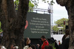
20170509_6305_7D2-62 Remembrance (129/365) Today was the first time I have been to the earthquake memorial since it was completed and opened on 22nd February 2017, six years after the devastating quake that killed the 185 that are named on this wall. I knew two of the people on the list.
20170704_9090_7D2-24 Only two left (185/365)
Images, eqnz.chch.2010
Only two of 20 houses left in the Rawhiti Earthquake Village. This from the sign on perimeter fence: "Since 2011, Rawhiti Domain has been used to provide temporary accommodation for those affected by the Canterbury earthquakes. Over 200 households have used the 20 houses while their own homes have been repaired or rebuilt. The demand for acco...
20170918_6084_7D2-41 Demolition still happening (260/365)
Images, eqnz.chch.2010
20170918_6084_7D2-41 Demolition still happening (260/365) Six ½ years after the earthquakes there are still a few demolitions taking place. This one is a block of council owned flats. Whether the whole complex is being demolished or not I don't know., but here the centre block of three is being demolished. The green grass is what was sections...
20171103_5588_1D3-70 Cabbage Tree in the Red Zone
Images, eqnz.chch.2010
An impressive Cabbage Tree (Cordyline australis) that was in someone's back yard prior to the demolition of houses post the 2011 earthquake.
Trees in the Red Zone (307/365)
Images, eqnz.chch.2010
20171103_5582_1D3-38 Trees in the Red Zone (307/365) In what used to be sections with houses and yards. Between late 2011 and 2014 the houses (well 95% of them) were removed due to land dropping in the 2011 earthquakes and the proximity of the Avon River, tidal in this area. #8859
20171103_5586_1D3-66 Phoenix Palm in the Red Zone
Images, eqnz.chch.2010
A Phoenis Palm (Phoenix canariensis) that was in someone's back yard prior to the demolition of houses post the 2011 earthquake.