
Search
found 264 results
Images for 100% Canon; more images...


Lupins in the Red Zone
Images, eqnz.chch.2010
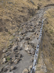
20131110_8308_EOS M-28 Lupins in the Red Zone Another empty Red Zone section. Avonside Drive, Dallington. #4393
20131110_8306_EOS M-55 Beauty in the Red Zone
Images, eqnz.chch.2010
There is some beauty in the desolate and near empty Dallington Red Zone.
20130206_0211_EOS M-55 Town Hall and Ferrier Fountain
Images, eqnz.chch.2010
None
20130902_2891_1D3-165 The view down the drive
Images, eqnz.chch.2010
Sewer repairs due to earthquake damage have our street totally closed off apart from pedestrian traffic down the footpath.
20130805_2212_1D3-120 Broken and closed
Images, eqnz.chch.2010
The South New Brighton Domain jetty into the Avon-Heathcote Estuary. A new jetty replaced an older one about 6-8 years ago, then the earthquakes happened! Before the earthquakes it was straight and level and open!
20130621_7828_1D3-130 Temporary Snow! (Day 172/365)
Images, eqnz.chch.2010
None
20130130_1811_1D3-17 ANZ Port-A-Com
Images, eqnz.chch.2010
When this building was first brought on site I spent a few hours removing the tape/paper that had been covering every window.
Broken footpath - Christchurch earthquake
Images, eqnz.chch.2010
20100904_3315_1D3-24 Broken footpath - Christchurch earthquake The footpath besides ANZAC Drive and the Bexley Wetlands. Liquefaction silt from well underground has flowed to the surface. Photo taken less than three hours after the 4:35am earthquake. #374
Bridge Street cracking - Christchurch earthquake
Images, eqnz.chch.2010
20100905_3346_1D3-24 Bridge Street cracking - Christchurch earthquake The city side of the South Brighton bridge. Approaches on both sides will need extensive work before this bridge can re-open. #379
20171103_5588_1D3-70 Cabbage Tree in the Red Zone
Images, eqnz.chch.2010
An impressive Cabbage Tree (Cordyline australis) that was in someone's back yard prior to the demolition of houses post the 2011 earthquake.
20171103_5586_1D3-66 Phoenix Palm in the Red Zone
Images, eqnz.chch.2010
A Phoenis Palm (Phoenix canariensis) that was in someone's back yard prior to the demolition of houses post the 2011 earthquake.
20120131_8167_1D3-400 Shag Pile
Images, eqnz.chch.2010
What more can one say except that Shag Rock is now about one third it's original height. Whitewash Head in the background with the road that now drops over a cliff.
20130424_6246_1D3-400 South New Brighton Jetty - 3
Images, eqnz.chch.2010
The jetty in the South New Brighton Domain was rebuilt a few years ago. It was straight and level till the earthquakes. Has been closed for 2½ years now. The shags like it though!
Castle Rock
Images, eqnz.chch.2010
20100913_3424_1D3-400 Castle Rock The damage to Castle Rock, overlooking the Heathcote Valley from the 7.1 earthquake on September 4th. #385
20120128_8071_1D3-400 Redcliffs wall
Images, eqnz.chch.2010
The sea wall at Beachville Road, Redcliffs, after the earthquake. It used to be straight and level - not now! As a teenager I went fishing off this wall.
20121117_2387_G12-06 New Brighton Road flooded again
Images, eqnz.chch.2010
With the land dropping about 1metre to 1.4metres after the earthquakes, a few roads besides the Avon and Heathcote Rivers are flooded with very high tides. Extra stop banks (on right) erected after the quakes have helped, but the road is now well below high water level. New Brighton Road, just short of New Brighton. The Pages Road bridge may b...
20130827_2620_1D3-32 Victoria Square Apartments
Images, eqnz.chch.2010
Awaiting the demolition ball! See the hole punched in by the neighbouring building (now demolished) during the February 22 2011 earthquake. This building is leaning to the north (left) while it's now demolished neighbour was leaning to the south (right). All because the crap land gave way underneath!
20130106_1236_1D3-60 Cathedral (006/365)
Images, eqnz.chch.2010
Deconstruction has been halted, but this was the front of Christchurch's most famous landmark. The tower/spire was above the nearest bit of remains.
20130827_2619_1D3-105 Queensland Search and Rescue sign
Images, eqnz.chch.2010
Exactly 2½ years (27/02/11 - 27/08/13) since the Queensland (Australia) SAR team TF1 spray painted this on a concrete fence in Armagh Street. Not many of these signs left now as many buildings have been demolished.
20121124_0566_1D3-67 Cunningham House
Images, eqnz.chch.2010
Cunningham House at the Christchurch Botanic Gardens is still closed due to earthquake damage. I wonder if it will ever re-open or suffer the demolition fate many other iconic structures in Christchurch have.
20130915_3522_1D3-55 Shock of the Millenium
Images, eqnz.chch.2010
The damaged (and once iconic Christchurch Cathedral) waits it's fate (repaired or demolish/rebuild) with the Millenium hotel in background.
Porritt Park - Christchurch earthquake
Images, eqnz.chch.2010
20100918_3497_1D3-24 Porritt Park - Christchurch earthquake The Avon River loop around Porritt Park has risen with the quake. Huge cracks are all through Porritt Park (rowing, hockey and cricket venue). The main section of the river is in a man made cut behind the buildings in the background of this pic. #401
Deans Homestead October 2008
Images, eqnz.chch.2010
20081011_1524_1D3-45 Deans Homestead October 2008 The historic Deans Homestead 23 months ago. Now destroyed in the Canterbury earthquake of September 4th 2010. This photo was taken on the PSNZ 2008 Southern Regional Photographic Convention bus trip. #384
20160307_6619_7D2-125 Covering up
Images, eqnz.chch.2010
One of the most beautiful pieces of wall art (added to the blank walls after buildings were demolished following the earthquakes) in Christchurch, is now being hidden by a new building in front of it. www.flickr.com/photos/johnstewartnz/15499321681/in/...
20160307_6626_7D2-200 Pigeon City
Images, eqnz.chch.2010
Pigeons sit on the remains of one of the tallest buildings in Christchurch that was 95% demolished two or three years ago. The basement (now filled with water) and the columns remain. Demolished due to damage from the Christchurch 2011 earthquake.
Ground movement Pacific Park - Christchurch earthquake
Images, eqnz.chch.2010
20100905_3336_1D3-24 Ground movement Pacific Park - Christchurch earthquake A house in Pacific Park (Bexley) that borders the Bexley Wetlands. Land moved towards the wetlands and the closer to wetlands the more severe the damage. #382
20130130_1861_1D3-47 St Lukes in the City - labyrinth
Images, eqnz.chch.2010
According to the sign it can take about 30 minutes to walk from the entry point (near the small statue) to the centre and out again. What you can do with a few thousand old bricks and gravel. See next photo for more detail.
South New Brighton bridge damage (under repair)
Images, eqnz.chch.2010
20130211_2645_1D3-840 South New Brighton bridge damage (under repair) Earthquake damage (that right hand abutment should be vertical with the bridge and the hand rail level). Bridge is closed to eastbound traffic (to left) and has a 3500kg weight limit as well. The eastern approach is the same. Damage caused mainly in the 04/09/10 and 22/02/11...
20130130_1862_1D3-24 St Lukes in the City - labyrinth
Images, eqnz.chch.2010
According to the sign it can take about 30 minutes to walk from the entry point (here) to the centre and out again. That is without stepping across the gaps between bricks. What you can do with a few thousand old bricks and gravel!
20120321_2416_1D3-24 Fallen Cone
Images, eqnz.chch.2010
A month after the 1st anniversary of the deadly Christchurch earthquake (22/02/11) a road cone lies on New Brighton Road, alongside the Avon River. Part of the earthquake 1st anniversary remembrance was for people to place flowers in road cones (and there are hundreds of thousands in the city). Many had flowers in them, as this one did. Photo ...