
Search
found 4186 results
Images for Christchurch street; more images...


Rydal Street sand volcanos
Images, eqnz.chch.2010
It would have been a glorious Spring day in Christchurch had it not been for the magnitude 7.1 earthquake at 4:30 am. All the water and silt you can see covering the street in this photo erupted from the ground following the earthquake.
Photographs of central Christchurch after the 2010 and 2011 earthquakes
Images, Alexander Turnbull Library
Photographs of central Christchurch after the 2010-2012 earthquakes taken 25 February 2012 by Sean McMahon. Locations are chiefly Manchester, Saint Asaph, Cashel, Columbo and Lichfield Streets, and the Bridge of Remembrance. Images show fencing around areas closed to the public, damaged and collapsed commercial buildings, cleared sites, re-opened Cashel Street area with shops and a cafe. Source of title - Title supplied by Library Quantity: 34 digital photograph(s).
BeckerFraserPhotos April 2011 photograph 106
Images, UC QuakeStudies
A view of the badly-damaged Arts Centre from Hereford Street. The gables of the building have been secured with wooden bracing and a pile of brickwork lies on the street below. Wire fencing has been placed around the building as a cordon.
BeckerFraserPhotos April 2011 photograph 107
Images, UC QuakeStudies
A view of the badly-damaged Arts Centre from Hereford Street. The gables of the building have been secured with wooden bracing and a pile of brickwork lies on the street below. Wire fencing has been placed around the building as a cordon.
Ready for reconstruction
Images, eqnz.chch.2010
None
Lyttelton Service Centre, London Street
Images, eqnz.chch.2010
Photos taken in Lyttelton showing the demolition at various locations following the February 22 earthquake. File reference: CCL-2011-05-20-Lyttelton-Demolition-P1120445 From the collection of Christchurch City Libraries.
The First Car Comes to Christchurch
Articles, Lost Christchurch
A Packing Case on Wheels Local and General. Star, Issue 6789, 8 May 1900, Page 3 A weird-looking vehicle has recently been seen travelling through the streets of the city much to the amusement and …
Waitaki Street a Week After the Quake
Images, UC QuakeStudies
Liquefaction and flooding in Waitaki Street, Bexley. The photographer comments, "Waitaki Street a week after the Christchurch Earthquake. Because of the damage to the drains and liquefaction in the area the streets are not drying out".
Christchurch Press Image: Carys Monteath, 2011:02:24 01:45:47
Images, UC QuakeStudies
Photograph captioned by Fairfax, "Christchurch Earthquake. London Street, Lyttelton".
Christchurch Press Image: Iain McGregor 2010:09:03 21:02:31
Images, UC QuakeStudies
Photograph captioned by Fairfax, "Earthquake hits Christchurch. Colombo Street".
Christchurch Press Image: Iain McGregor 2010:09:03 21:58:02
Images, UC QuakeStudies
Photograph captioned by Fairfax, "Earthquake in Christchurch. Victoria Street".
Christchurch Press Image: Iain McGregor 2010:09:03 21:02:28
Images, UC QuakeStudies
Photograph captioned by Fairfax, "Earthquake hits Christchurch. Colombo Street".
North face of Anderson's Building
Images, UC QuakeStudies
A colour photograph of the north face of the Anderson's Building, viewed from Cashel Street taken before the earthquakes.
Christchurch Earthquake - Police stopped me getting closer
Images, eqnz.chch.2010
A view after the 7.1 magnitude earthquake in Christchurch. cnr Lichfield and Colombo Streets, looking south.
Christchurch Press Infographic: 29 August 2012
Images, UC QuakeStudies
A page banner promoting an article titled, "New Regent Street plans on track".
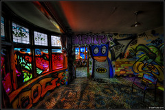
Forgotten Street Art
Images, UC QuakeStudies
Graffiti on a damaged building on Colombo Street. The photographer comments, "This street art has been unseen by the general Christchurch population as it was off limits in the Red Zone".
Julia Holden's 2013 Photographs 087
Images, UC QuakeStudies
A photograph of the Telogis Concept Christchurch project on the corner of Tuam Street and Madras Street. The project was organised by the Student Volunteer Army and Life in Vacant Spaces.
Julia Holden's 2013 Photographs 178
Images, UC QuakeStudies
A photograph of the Telogis Concept Christchurch project on the corner of Tuam Street and Madras Street. The project was organised by the Student Volunteer Army and Life in Vacant Spaces.
Blue Building Christchurch Billboard 3
Images, UC QuakeStudies
A photograph of Julia Holden's painting 'Blue Building' displayed on a billboard on Ferry Road in Christchurch.
Blue Building Christchurch Billboard 2
Images, UC QuakeStudies
A photograph of Julia Holden's painting 'Blue Building' displayed on a billboard on Ferry Road in Christchurch.
Blue Building Christchurch Billboard 1
Images, UC QuakeStudies
A photograph of Julia Holden's painting 'Blue Building' displayed on a billboard on Ferry Road in Christchurch.
Christchurch: The Transitional City Pt IV, pages 104-105: SCAPE
Articles, UC QuakeStudies
A PDF copy of pages 104-105 of the book Christchurch: The Transitional City Pt IV. The pages document the transitional project 'SCAPE'. Image: Ash Keating, Gardensity, 2010/11, commissioned by SCAPE with generous support from Leighs Construction and Portabuild, installed outside Christchurch Art Gallery. Photo used with permission: SCAPE.
Damage to the former Christchurch City Council building
Images, UC QuakeStudies
Damage to the former Christchurch City Council building on Tuam Street.
Christchurch Press Infographic: 26 October 2012 (4)
Images, UC QuakeStudies
A page banner promoting an article titled, "Town Hall in balance".
Elizabeth Ackermann Photograph 349
Images, UC QuakeStudies
A photograph looking east down Gloucester Street, towards the intersection of Manchester Street. On-lookers are surveying earthquake damage from behind the cordon. The Christchurch City Council parking building can be seen in the distance.
BeckerFraserPhotos March 2013 photograph 103
Images, UC QuakeStudies
An aerial photograph looking north over the Christchurch CBD from Lichfield Street along Colombo Street. The brightly coloured roofs of the Re:Start mall can be seen in the bottom centre of the photograph.
BeckerFraserPhotos December 2011 photograph 0339
Images, UC QuakeStudies
An aerial photograph of Christ Church Cathedral.
BeckerFraserPhotos May 2012 photograph 176
Images, UC QuakeStudies
Photograph captioned by BeckerFraserPhotos, "Oran and Waitaki Streets, Bexley".
BeckerFraserPhotos May 2011 photograph 0714
Images, UC QuakeStudies
Photograph captioned by BeckerFraserPhotos, "Unfamiliar view from Durham Street as Laycocks building has been demolished".
Snapshot 2 - Madras Street
Images, UC QuakeStudies
A snapshot from GPS Boomerang's SmartBird flight over the Christchurch red zone on 23 December 2012, looking over Madras Street with the High Street shops in the bottom left.