
Search
found 1843 results
Images for #eqnz; more images...


20120131_8129_1D3-400 Eathquake damage
Images, eqnz.chch.2010
Houses teeter over the edge above Redcliffs School.
20111229_7210_1D3-195 Bexley Wetlands and Pacific Park
Images, eqnz.chch.2010
The flooded Bexley Wetlands, now about 1 - 1.5metre below pre earthquake level. The short length of fence (mid ground) was on the "river track" that the council closed about three years ago. The whole track in this view is now under about 500mm water at high tide. The main track in front of the houses was, prior to earthquakes, below the leve...
Eathquake damage
Images, eqnz.chch.2010
20120131_8174_1D3-400 Eathquake damage Houses above Main Road, Sumner. #2153
20120129_8116_1D3-200 Pleasant Point Yacht Club
Images, eqnz.chch.2010
The small wharf area of the now gone Pleasant Point Yacht Club has already been taken over by the Pied Shags (cormorants). It is under water now except for low tide. Note the dead pine tree in background. Many have died because of the salt water their roots are in.
20120131_8198_1D3-400 Eathquake damage
Images, eqnz.chch.2010
Damaged houses above Shag Rock.
20130618_7684_1D3-200 Sumner Road Closed
Images, eqnz.chch.2010
None
20130622_7842_1D3-24 Disabled in more ways than one (Day 173/365)
Images, eqnz.chch.2010
One of many disabled carparks outside what used to be one of the great sporting complexes in New Zealand. The Queen Elizabeth II Park complex in north-east Christchurch was built initially for the 1974 Commonwealth Games and was used for track and field and the adjoining pool complex had swimming and diving. It was built on an area that was used...
20130627_8864_1D3-32 Pay Here
Images, eqnz.chch.2010
Maybe it should be titled "Pray Here"! The old church buildings next to the Christchurch Basilica (Cathedral of the Blessed Sacrament) have been demolished and replaced with ANOTHER Wilson's Car Park. Hundreds of sites in the city where buildings have been demolished after the earthquakes have been replaced in the short term by car parks!
20130524_7201_1D3-32 Demolition of houses in Bexley is ongoing
Images, eqnz.chch.2010
None
20130524_7207_1D3-75 Earthquake damage to a Hulverstone Drive house
Images, eqnz.chch.2010
Awaiting demolition
My trees have gone!
Images, eqnz.chch.2010
20130613_7577_1D3-24 My Trees cut down so a house being removed from behind could get out above the fence on one of those elevating house removal trailers. I don't know the story about the yellow (recycling) wheelie bin - the wheels have been removed. This was my house from March 2004 to mid-2012 when it was purchased by the government as it s...
Warning (Day 220/365)
Images, eqnz.chch.2010
20130808_2300_1D3-40 Warning (Day 220/365) Across the river were a row of several houses - all gone now. That side of the river is "Red Zone" and will be devoid of houses soon. #4077
Christchurch, NZ - Post Feb Earthquake, 2011
Images, eqnz.chch.2010
Taken during a scenic flight over Christchurch, New Zealand, 3 months after the deadly earthquake of 22 February, 2011. Much of the inner city CBD is still cordoned off and will be for some time. About 900 buildings are set for demolition. Taken aboard the Southern DC3 www.so...
Why?
Images, eqnz.chch.2010
Tell me... Why This is the path I'll never tread These are the dreams I'll dream instead This is the joy that's seldom spread These are the tears... The tears we shed This is the fear This is the dread These are the contents of my head And these are the years that we have spent And this is what they represent And this is how I feel Do you know h...
Christchurch Earthquake 2011 - Old Sydenham Post Office
Images, eqnz.chch.2010
Revisiting some of my images coming up to our one year anniversary of the 22 February 2011 Christchurch 6.3 earthquake. Blue Jean Cuisine (Old Sydenham Post Office) built in 1911 was badly damaged in the 2011 earthquakes was demolished 2012.
20120131_8169_1D3-400 Conatiner wall
Images, eqnz.chch.2010
Part of a house that fell can be seen on the rocks above right hand containers.
After The Earth Quaked - The Christchurch Earthquakes
Images, eqnz.chch.2010
My new photographic book about the Christchurch Earthquakes is hot off the presses at Blurb! Take a sneak peek... View my book at Blurb: www.blurb.com/bookstore/invited/2315509/c1c27e503cee584ca...
Christchurch - Earthquake Rebuild - Temporary CBD
Images, eqnz.chch.2010
Christchurch - Earthquake Rebuild - Temporary CBD Christchurch City CBD Cashel Street Christchurch Canterbury New Zealand © 2011 Phil Le Cren Photo Taken With: Canon EOS 1000D + Canon EF/EF-S lenses + 10.1 effective megapixels + 2.5-inch TFT color LCD monitor + Eye-level pentamirror SLR + Live View shooting. + EOS Built-in Sensor...
Christchurch, NZ - Cashel Mall Restart
Images, eqnz.chch.2010
The CBD is slowly being opened up and this is the post - earthquake result of Cashel Mall. A vibrant, fresh look with high end shopping in colourful container shops. A really good step forward for the city.
Canterbury Earthquake 2011
Images, eqnz.chch.2010
Our Street - Liquefaction Sand (23.02.2011) Woolston Christchurch Canterbury New Zealand © 2011 Phil Le Cren Photo Taken With: Canon EOS 1000D + Canon EF/EF-S lenses + 10.1 effective megapixels + 2.5-inch TFT color LCD monitor + Eye-level pentamirror SLR + Live View shooting. + EOS Built-in Sensor cleaning system + ...
Canterbury Earthquake 2011
Images, eqnz.chch.2010
Picture Framing Gallery, Ferry Rd (23.02.2011) Woolston Christchurch Canterbury New Zealand © 2011 Phil Le Cren Photo Taken With: Canon EOS 1000D + Canon EF/EF-S lenses + 10.1 effective megapixels + 2.5-inch TFT color LCD monitor + Eye-level pentamirror SLR + Live View shooting. + EOS Built-in Sensor cleaning system...
Canterbury Earthquake 2011
Images, eqnz.chch.2010
Vehicles Stuck - Our Street - Liquefaction (23.02.2011) Woolston Christchurch Canterbury New Zealand © 2011 Phil Le Cren Photo Taken With: Canon EOS 1000D + Canon EF/EF-S lenses + 10.1 effective megapixels + 2.5-inch TFT color LCD monitor + Eye-level pentamirror SLR + Live View shooting. + EOS Built-in Sensor cleani...
Canterbury Earthquake 2011
Images, eqnz.chch.2010
Picture Framing Gallery, Ferry Rd (23.02.2011) Woolston Christchurch Canterbury New Zealand © 2011 Phil Le Cren Photo Taken With: Canon EOS 1000D + Canon EF/EF-S lenses + 10.1 effective megapixels + 2.5-inch TFT color LCD monitor + Eye-level pentamirror SLR + Live View shooting. + EOS Built-in Sensor cleaning system...
Canterbury Earthquake 2011
Images, eqnz.chch.2010
Hargood Street (23.02.2011) Woolston Christchurch Canterbury New Zealand © 2011 Phil Le Cren Photo Taken With: Canon EOS 1000D + Canon EF/EF-S lenses + 10.1 effective megapixels + 2.5-inch TFT color LCD monitor + Eye-level pentamirror SLR + Live View shooting. + EOS Built-in Sensor cleaning system + Wide-area 7 poin...
SuperValue Coming Down
Images, eqnz.chch.2010
Edgeware Supervalue Supermarket being demolished after the 6.3 magnitude quake hit Christchurch 22 February 2011. ♥An attempt to capture the movement of the wall coming down with 3 exposure and HDR processing.
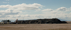
Christchurch Earthquake - Shag Rock
Images, eqnz.chch.2010
Shag Rock, also known as Rapanui Rock, crumbled to a third of its original size after the magnitude 6.3 quake hit Christchurch 22 February 2011
Christchurch Earthquake 2011 - Catholic Cathedral
Images, eqnz.chch.2010
The dome of Christchurch's Catholic Cathedral of the Blessed Sacrament will be removed amid fears it may topple after the 6.3 magnatude quake hit Christchurch 22 February 2011.
Christchurch Earthquake 2011 - Rose Historic Chapel Broken
Images, eqnz.chch.2010
Sadly the Chapel has been badly damaged in the magnitude 6.3 earthquake that hit Christchurch 22 February 2011. See below. The Rose Historic Chapel formerly St Mary’s Convent Chapel is the sole survivor of a group of heritage buildings in Christchurch that once comprised the St Mary’s Convent complex for the Sisters of Mercy in North Colombo St...
Christchurch Earthquake 2011 - Gnome Away From Home
Images, eqnz.chch.2010
After the liquefaction has been cleaned up we have piles of the stuff on our streets waiting for the council to pick it up. This little Gnome is obviously doing its bit as Christchurch cleans up after the 6.3 magnitude quake 22 February 2011.
Christchurch Earthquake 2011 - Kia Kaha Christchurch
Images, eqnz.chch.2010
Kia Kaha (in the little red love-heart on the fence) can be translated from the Maori language as “Be strong and fearless!” “Be Proud!” or “Stand tall!” The term is used in many situations to give encouragement and support to family, friends and mates. Taken one week after the 6.3 magnitude quake hit Christchurch 22 February 2011. Proce...