
Search
found 1396 results
Images for Christchurch Central; more images...


BeckerFraserPhotos September 2011 photograph 570
Images, UC QuakeStudies
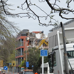
Photograph captioned by BeckerFraserPhotos, "Looking from Gloucester Street across the demolition site of the Coachman and Canterbury Times (Christchurch Star?) buildings with Heritage Hotel on the left and Novotel in the centre".
BeckerFraserPhotos September 2011 photograph 569
Images, UC QuakeStudies
Photograph captioned by BeckerFraserPhotos, "Looking from Gloucester Street across the demolition site of the Coachman and Canterbury Times (Christchurch Star?) buildings with Heritage Hotel on the left and Novotel in the centre".
BeckerFraserPhotos September 2011 photograph 574
Images, UC QuakeStudies
Photograph captioned by BeckerFraserPhotos, "Looking from Gloucester Street across the demolition site of the Coachman and Canterbury Times (Christchurch Star?) buildings with Heritage Hotel on the left and Novotel in the centre".
Performance of Bridges during the 2010 Darfield and 2011 Christchurch Eart…
Research papers, The University of Auckland Library
The region in and around Christchurch, encompassing Christchurch city and the Selwyn and Waimakariri districts, contains more than 800 road, rail, and pedestrian bridges. Most of these bridges are reinforced concrete, symmetric, and have small to moderate spans (15–25 m). The 22 February 2011 moment magnitude (Mw) 6.2 Christchurch earthquake induced high levels of localized ground shaking (Bradley and Cubrinovski 2011, page 853 of this issue; Guidotti et al. 2011, page 767 of this issue; Smyrou et al. 2011, page 882 of this issue), with damage to bridges mainly confined to the central and eastern parts of Christchurch. Liquefaction was evident over much of this part of the city, with lateral spreading affecting bridges spanning both the Avon and Heathcote rivers.
Nisbet, Alistair, 1958- :'CBD Red Zone Tours'. 22 October 2011
Images, Alexander Turnbull Library
Depicts huge elderly woman with 'CERA' on her dress scolding smaller adult dressed as schoolboy near bustop with sign 'CBD red zone tours' Text reads 'And don't talk to strangers and don't cross the road and remember to eat your lunch..' Context: After the 22 Feburary 2011 earthquake in Christchurch, the central business district (CBD) was marked as a red zone. Red zone areas were deemed unsuitable for habitation due to significant damage and at high risk of further damage from low levels of earth shaking. CERA (Christchurch Earthquake Recovery Authority) ran public bus tours of the Christchurch CBD from November to December 2011. For safety reasons the public was not allowed off the buses as it was a dangerous and active demolition site. Quantity: 1 digital cartoon(s).
BeckerFraserPhotos December 2011 photograph 0115
Images, UC QuakeStudies
A plaque on the side of the Edmonds Band Rotunda on Cambridge Terrace. The plaque reads, "This rotunda shelter and circular seat were presented by T.J.Edmonds to celebrate fifty years of residence in Christchurch 26th September 1929".
WEMO ERT Set 3 - February 2011 - Photograph 025
Images, UC QuakeStudies
A photograph of members of the Wellington Emergency Management Office Emergency Response Team talking to a member of the New South Wales USAR team in Latimer Square.
WEMO ERT Set 1 - February 2011 - Photograph 07
Images, UC QuakeStudies
A photograph of the USAID headquarters in Latimer Square. A sign above the entrance to the camp reads, "Must wash hands". Whiteboards placed around the entrance read, "Please wash hands before taking food".
WEMO ERT Set 1 - February 2011 - Photograph 31
Images, UC QuakeStudies
A photograph of a Singapore Rescue Team tent set up in Latimer Square after the 22 February 2011 earthquake. In the foreground there is a group of tents, cordoned off with tape and plastic mesh.
WEMO ERT Set 3 - February 2011 - Photograph 080
Images, UC QuakeStudies
A photograph of members of the Wellington Emergency Management Office Emergency Response Team examining the Southern Finance Ltd building. Silt from liquefaction covers part of the footpath and road.
WEMO ERT Set 3 - February 2011 - Photograph 092
Images, UC QuakeStudies
A photograph of the southern end of the Provincial Chambers Building taken through a car window. The roof and the wall of the building have collapsed on the right.
WEMO ERT Set 3 - February 2011 - Photograph 053
Images, UC QuakeStudies
A photograph of tents pitched at the On-Site Operations Coordination Centre (OSOCC) in Latimer Square. The OSOCC was set up by the United Nations Emergency Relief Coordinator.
WEMO ERT Set 3 - February 2011 - Photograph 168
Images, UC QuakeStudies
A photograph of a member of the Wellington Emergency Management Office Emergency Response Team standing in a car park in the Christchurch central city. In the background is the Hotel Grand Chancellor. The hotel has a noticeable slump on the left side.
WEMO ERT Set 3 - February 2011 - Photograph 169
Images, UC QuakeStudies
A photograph of a member of the Wellington Emergency Management Office Emergency Response Team standing in a car park in the Christchurch central city. In the background is the Hotel Grand Chancellor. The hotel has a noticeable slump on the left side.
New Zealand Defence Force photograph 715
Images, UC QuakeStudies
Members of various Search and Rescue teams after their shift in the central city. On the left is Shane from the New Zealand USAR team, centre, Suzy from the New Zealand Police, and right is Terry from Singapore's USAR team.
Paul and Sam Corliss's Street Art Photograph (2011:06:24 02:37:27)
Images, UC QuakeStudies
A photograph of street art on the side of an electricity substation on St Asaph Street. The artwork includes a Maori heimatau (fish hook) motif. Search and rescue codes have been spray-painted on the door of the building.
Fairfax Video, December 2011 (4)
Videos, UC QuakeStudies
A video of a tour through the Christchurch central city Red Zone. The video includes footage of the Hotel Grand Chancellor, Victoria Square, the Forsyth Barr building, Colombo Street, Gloucester Street, Cathedral Square, the BNZ building, Cashel Mall, and the Kathmandu store on High Street.
BeckerFraserPhotos December 2011 photograph 0362
Images, UC QuakeStudies
An aerial photograph of Bangor Street in central Christchurch. The photograph has been captioned by BeckerFraserPhotos, "Avon Loop. Some of this is zoned green and the land to the right of Bangor Street is zoned orange (plus the piece above Willow Street)".
WEMO ERT Set 1 - March 2011 - Photograph 81
Images, UC QuakeStudies
A photograph of the earthquake damage to a building in central Christchurch. The basement of the building has collapsed and the concrete blocks have broken away from each other. The left corner of the building has also suffered damage, with many of the concrete blocks shaking loose.
BeckerFraserPhotos December 2011 photograph 0320
Images, UC QuakeStudies
An aerial photograph of the Christchurch central city. The photograph has been captioned by BeckerFraserPhotos, "This photograph shows nearly all of the CBD. The two streets which are prominent in this photograph are Manchester Street on the left and Colombo Street on the right of the photograph. This photograph is from the north, looking towards the southern part of the city. Cathedral Square is about half way up, towards the right. It shows the extent of demolition that has happened already close to the river and near the Manchester/Gloucester Street intersection where there is a lot of bare land surrounding Radio Network House".
BeckerFraserPhotos December 2011 photograph 0282
Images, UC QuakeStudies
An aerial photograph of the IRD Building in the Christchurch central city and the surrounding area. The photograph has been captioned by BeckerFraserPhotos, "There are many empty sites in this part of the CBD. The street running up the photograph from the left to the right is Cashel Street. The empty site left of centre with the trees is where St John's Church has been demolished. To the left of the IRD building, is the site of the CTV Building".
WEMO ERT Set 1 - March 2011 - Photograph 79
Images, UC QuakeStudies
A photograph of the earthquake damage to a block of buildings in central Christchurch. The basement of the buildings have collapsed and the concrete blocks have spilled into the car park. Large cracks have also formed in between the blocks in the walls of the building to the left.
WEMO ERT Set 1 - March 2011 - Photograph 75
Images, UC QuakeStudies
A photograph of the earthquake damage to a building in central Christchurch. Broken glass and other rubble litters the courtyard in front of the building. There is a large crack in the brick wall to the right. A red sticker on the glass door indicates that the building is unsafe to enter.
WEMO ERT Set 3 - February 2011 - Photograph 018
Images, UC QuakeStudies
A photograph of workers preparing breakfast for the emergency management personnel in Latimer Square. The workers are wearing high-visibility vests and hair nets. A sign on one of the tent poles reads, "Please wash hand before approaching the food tables, thank you".
WEMO ERT Set 3 - February 2011 - Photograph 019
Images, UC QuakeStudies
A photograph of a member of the Wellington Emergency Management Office Emergency Response Team lining up for breakfast in Latimer Square. To the right, members of the New South Wales USAR team are also getting breakfast.
BeckerFraserPhotos December 2011 photograph 2386
Images, UC QuakeStudies
A photograph captioned by BeckerFraserPhotos, "The Christchurch Central Police Station. It has recently been announced that the Police will vacate this building, as it is not considered safe enough for Police headquarters. It is not clear what will happen to the building which may be strong enough for a less critical operation".
WEMO ERT Set 2 - February 2011 - Photograph 04
Images, UC QuakeStudies
A member of the Wellington Emergency Management Office Emergency Response Team team attempting to enter the City Care building on Antigua Street. A green sticker on the door indicates that the building has been inspected and is safe to enter.
Digital Photograph: Queenstown Memorial
Images, Canterbury Museum
One landscape colour digital photograph taken on 1 March 2011 showing a band playing in the memorial service in Queenstown's central square. The 6.3 magnitude earthquake that struck Christchurch on 22 February 2011 shocked most New Zealanders. Memorial services were held around the country, many were held in conjunction with a fundraising initi...
Digital Photograph: Queenstown Memorial
Images, Canterbury Museum
One landscape colour digital photograph taken on 1 March 2011 showing the crowd gathered for a memorial service in Queenstown's central square. The 6.3 magnitude earthquake that struck Christchurch on 22 February 2011 shocked most New Zealanders. Memorial services were held around the country, many were held in conjunction with a fundraising in...
Image 5 - Territorial Force
Images, UC QuakeStudies
An image from a Army News March 2011 article titled, "Territorial Force". The image shows members of the Central and Lower North Island Territorial Units clearing silt from a resident's garden in east Christchurch. On the left is Private Quentin Chat of Taranaki, and Corporal Samuel Hatcher of Wellington is on the right.