
Search
found 1843 results
Images for #eqnz; more images...


The Earthquake giants
Images, eqnz.chch.2010
Damaged Christchurch building (old Para Rubber building - see earlier photo from just after quake), partially demolished, after Sept 4th 2010 Christchurch earthquake. Has been sitting on 666 views for a while!
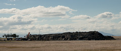
Castle Rock Fall
Images, eqnz.chch.2010
Can't believe how much of this rock fell off! Its looks totally different - no longer a castle. Sad but very glad that the huge rock did not hit anything on the way down!
Window Painful
Images, eqnz.chch.2010
None
IMG_7298
Images, eqnz.chch.2010
Monavale, a publicly owned heritage building and gardens - can't see it surviving this one.
Cathedral on Barbadoes St, Christchurch
Images, eqnz.chch.2010
Pre Earthquake
Churchills Tavern
Images, eqnz.chch.2010
Corner of Colombo St and Battersea St. A lot more of the fascade has collapsed.
Christchurch Earthquake 2011 - Shaky Ride
Images, eqnz.chch.2010
None
Colombo Street, Sydenham.
Images, eqnz.chch.2010
former site of sweet shop, Christchurch City Mission charity shop and Soul Food Cafe
earthquake damage
Images, eqnz.chch.2010
Damage from the Christchurch 7.1 earthquake on 4th Sept 2010
earthquake damage
Images, eqnz.chch.2010
Damage from the Christchurch 7.1 earthquake on 4th Sept 2010
Art Centre
Images, eqnz.chch.2010
Damage from the Christchurch 7.1 earthquake on 4th Sept 2010
Art Gallery
Images, eqnz.chch.2010
None
20130915_3524_1D3-55 The Chalice and the remains
Images, eqnz.chch.2010
None
20130915_3540_1D3-92 Cardboard Cathedral
Images, eqnz.chch.2010
None
The day after the 7.1
Images, eqnz.chch.2010
Christchurch city experienced a magnitude 7.1 earthquake on September 4 at 4:35 am. The epicentre was 40 km west of the city. It was the most damaging earthquake in New Zealand since the Hawke's Bay earthquake in 1931, but there was no loss of life. It was fortunate the earthquake occurred when the central city streets were deserted, as there w...
ChCh quake (Explore #84 04/09/10) & Flickrblog
Images, eqnz.chch.2010
A local resident walks to the nearest dairy for essentials after the 7.1 magnitude quake, that has caused major infrastructure damage to Christchurch City.
The Press Building
Images, eqnz.chch.2010
Pre-February Earthquake
Lancaster Park
Images, eqnz.chch.2010
Helicopter Flight over Christchurch New Zealand
P1020978-2
Images, eqnz.chch.2010
Christchurch's Cathedral
Remembering...
Images, eqnz.chch.2010
None
Church after 22 Feb earthquake
Images, eqnz.chch.2010
Church of St. John the Baptist, Latimer Square, Christchurch, New Zealand
Is there ...
Images, eqnz.chch.2010
rubble from earthquake at Papanui Corner
City Centre
Images, eqnz.chch.2010
None
The Coptic Church, Edgeware Road
Images, eqnz.chch.2010
None
Colombo Street, Sydenham
Images, eqnz.chch.2010
The Greek Souvlaki place was closed for several months while the building next door got demolished.
Earthquake shopping
Images, eqnz.chch.2010
sorry not a good photo but this is a quick trip to the supermarket 3 days after the earthquake in Christchurch
Medway Street Bridge
Images, eqnz.chch.2010
The center of the river has slumped and the two banks have moved about a meter closer together which caused this footbridge to be so twisted. There is a suggestion that this be left as a memorial to the earthquake.
20130206_0211_EOS M-55 Town Hall and Ferrier Fountain
Images, eqnz.chch.2010
None
St Pauls school playground adjacent to church - that is not a wall at the …
Images, eqnz.chch.2010
The line that runs across this picture is the subsidence line - everything this side of the line has sunk by about 50 cm.
River Avon - duck
Images, eqnz.chch.2010
The center of the river has slumped and the two banks have moved about a meter closer together which caused this footbridge to be so twisted. There is a suggestion that this be left as a memorial to the earthquake.