
Search
found 1290 results
Images for September 2010 Canterbury Earthquake; more images...


"Canterbury?" "No - The ACT Party" 17 September 2010
Images, Alexander Turnbull Library
A man reads a newspaper with a headline 'Aftershocks'. His wife thinks it refers to the Canterbury earthquake of 4th September but it actually refers to the implosion of the ACT Party. Quantity: 1 digital cartoon(s).
Fairfax Video, September 2010 (31)
Videos, UC QuakeStudies
Aerial footage of Canterbury and the Christchurch central city after the 4 September 2010 earthquake. The footage shows the earthquake damage to Homebush, St John's Church in Hororata, the railway tracks near Rolleston, and Westende Jewellers on Colombo Street. It also shows flooding in the streets of New Brighton.
Nisbet, Alistair, 1958-: The next stage in earthquake prediction?... 27 Ja…
Images, Alexander Turnbull Library
The title is 'The next stage in earthquake prediction?... Six images show 'aromatherapists', auctioneers', chiropractors', fortune tellers', a 'sixth sense' and 'psychics'. Context - reference to all the unscientific ways of trying to predict earthquakes particularly dear to the hearts of Christchurch people who are enduring numerous aftershocks following the earthquake of 4th September 2010. Quantity: 1 digital cartoon(s).
Geotechnical Aspects of the 2010 Darfield (Canterbury) Earthquake
Research papers, University of Canterbury Library
On 4 September 2010, a magnitude Mw 7.1 earthquake struck the Canterbury region on the South Island of New Zealand. The epicentre of the earthquake was located in the Darfield area about 40 km west of the city of Christchurch. Extensive damage was inflicted to lifelines and residential houses due to widespread liquefaction and lateral spreading in areas close to major streams, rivers and wetlands throughout Christchurch and Kaiapoi. Unreinforced masonry buildings also suffered extensive damage throughout the region. Despite the severe damage to infrastructure and residential houses, fortunately, no deaths occurred and only two injuries were reported in this earthquake. From an engineering viewpoint, one may argue that the most significant aspects of the 2010 Darfield Earthquake were geotechnical in nature, with liquefaction and lateral spreading being the principal culprits for the inflicted damage. Following the earthquake, an intensive geotechnical reconnaissance was conducted to capture evidence and perishable data from this event. This paper summarizes the observations and preliminary findings from this early reconnaissance work.
IMG_2232
Images, eqnz.chch.2010
The ground slipped laterally at this previously unknown faultline across Highfield Road in mid-Canterbury, resulting in a relative displacement of at least 2 metres and the magnitude 7.1 earthquake on Saturday 4 September 2010. Note the now misaligned fence posts, hedge and road.
Photo 013
Images, UC QuakeStudies
Police tape cordons off large cracks in the road beside large piles of liquefaction dug from people's houses on a street in Avonside after the September 4th earthquake.
Photo 036
Images, UC QuakeStudies
Workers digging up the road on the corner of Avonside Drive and Retreat Road in Avonside, with road cones and "Road Closed" sign, after the September 4th earthquake.
Fairfax Video, September 2010 (35)
Videos, UC QuakeStudies
A video of TVNZ's Breakfast show broadcasting live from Cathedral Square. Presenters Paul Henry and Pippa Wetzel have flown down to Christchurch to record a special show titled "Breakfast for Canterbury", which aims to celebrate the Canterbury region's resilience in the aftermath of the 4 September 2010 earthquake.
Rock 'n roll... 19 October 2010
Images, Alexander Turnbull Library
The cartoon shows the name 'Christchurch' shaking so that bits fly off it; the letters 'H', 'I', and 'T' spelling 'hit' are the only ones not shaking. A second version has the words 'Rock'n Roll' as a title. Refers to the earthquake of 4th September 2010 and its hundreds of aftershocks which continue on now into November. Two versions of this cartoon are available Quantity: 1 digital cartoon(s).
Book: Christchurch, A Nostalgic Tribute
Images, Canterbury Museum
One multi-coloured softcover book titled 'Christchurch, A Nostalgic Tribute' with colour photographs and text by Peter Morath, published by the Caxton Press, Christchurch, 2011. Christchurch city was badly damaged during the 4 September 2010 and 22 February 2011 earthquakes and will change dramatically as rebuilding progresses. ‘Christchurch: A...
Photo 068
Images, UC QuakeStudies
Liquefaction 'volcanos' in Kaiapoi, after the September 4th earthquake. Silt erupted out of the ground, piling up over the surface and leaving cracks at the mouth of the volcano.
Photo 053
Images, UC QuakeStudies
Liquefaction 'volcanos' in Kaiapoi, after the September 4th earthquake. Silt erupted out of the ground, piling up over the surface and leaving cracks at the mouth of the volcano.
Photo 062
Images, UC QuakeStudies
Liquefaction 'volcanos' in Kaiapoi, after the September 4th earthquake. Silt erupted out of the ground, piling up over the turf and leaving cracks at the mouth of the volcano.
Photo 067
Images, UC QuakeStudies
Liquefaction 'volcanos' in Kaiapoi, after the September 4th earthquake. Silt erupted out of the ground, piling up over the surface and leaving cracks at the mouth of the volcano.
Photo 069
Images, UC QuakeStudies
Liquefaction 'volcanos' in Kaiapoi, after the September 4th earthquake. Silt erupted out of the ground, piling up over the surface and leaving cracks at the mouth of the volcano.
Photo 064
Images, UC QuakeStudies
Liquefaction 'volcanos' in Kaiapoi, after the September 4th earthquake. Silt erupted out of the ground, piling up over the surface and leaving cracks at the mouth of the volcano.
Photo 070
Images, UC QuakeStudies
Liquefaction 'volcanos' in Kaiapoi, after the September 4th earthquake. Silt erupted out of the ground, piling up over the surface and leaving cracks at the mouth of the volcano.
Elizabeth Ackermann Photograph 019
Images, UC QuakeStudies
A photograph of a staff member entering an office in the Department of Civil and Natural Resources Engineering at the University of Canterbury, after the 4 September 2010 earthquake.
The Vault for 3 December 2010 - Homebush
Audio, Radio New Zealand
Deborah Nation dusts off a series of recordings made with successive generations of a Canterbury lineage whose family homestead was one of the casualties of the earthquake on 4 September 2010 .
Systematic vertical ground motion observations in the Canterbury earthquak…
Research papers, University of Canterbury Library
The 2010-2011 Canterbury earthquake sequence was extremely damaging to structures in Christchurch and continues to have a large economic and social impact on the city and surrounding regions. In addition to strong ground shaking (Bradley and Cubrinovski 2011 SRL; Bradley 2012 SDEE), extensive liquefaction was observed, particularly in the 4 September 2010 Darfield earthquake and the 22 February 2011 Christchurch earthquake (Cubrinovski et al. 2010 BNZSEE; 2011 SRL). Large observed vertical ground motion amplitudes were recorded in the events in this sequence, with vertical peak ground accelerations of over 2.2g being observed at the Heathcote Valley Primary School during the Christchurch earthquake, and numerous other vertical motions exceeding 1.0g (Bradley and Cubrinovski 2011 SRL; Bradley 2012 SDEE; Fry et al 2011 SRL). Vertical peak ground accelerations of over 1.2g were observed in the Darfield earthquake.
Tremor Strike. Simply guess the magnitude of the next four consecutive aft…
Images, Alexander Turnbull Library
A Lotto game called 'Tremor Strike' invites people to 'Simply guess the magnitude of the next four consecutive aftershocks and WIN BIG!' Four differently coloured balls each with a tremor magnitude number bounce across the shaking ground. Refers to the earthquake of 4th September and the continuing aftershocks. Quantity: 1 digital cartoon(s).
Photo 099
Images, UC QuakeStudies
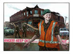
Damage to a residential property on Chichester Street in Pines Beach, after the September 4th earthquake. "Danger Keep Out" tape bars off entry to the collapsing side of the house.
Life in the South Island.. 20 September 2010
Images, Alexander Turnbull Library
The cartoon's title is 'Life in the South Island'. A man wonders aloud to his wife when the 'plague of locusts' will arrive as they have had 'collapsing finance companies, earthquakes' and 'heavy snow damage'. Refers to the collapse of South Canterbury Finance, the earthquake of 4th September, and more recently, heavy snow in Southland that has caused roofs to collapse. Quantity: 1 digital cartoon(s).
Crumbled
Images, eqnz.chch.2010
"Open Theatre" - The Odeon Built in 1883 and known as the Tuam Street Hall or Theatre and was New Zealand's oldest masonry, purpose built theatre. In 1930, it became the St. James Theatre, It became The Odeon Movie Theatre in 1960. Demolition started in September 2012 after the Christchurch earthquakes of 2010/2011 but seems to have stopped!?
Digital Photograph: Former Convent of Our Lady of Mercy, Exeter Street, Ly…
Images, Canterbury Museum
One landscape colour digital photograph taken on 12 April 2011 showing earthquake damage to the former Convent of Our Lady of Mercy. St Mary's School, run by the Sisters of Mercy, was also housed in this building. At the time of the 4 September 2010 earthquake the building was a private residence. The sense of loss felt when confronted with the...
Builder says he couldn't wait to leave CTV days before collapse
Audio, Radio New Zealand
An experienced builder says he couldn't wait to get out of the Canterbury Television Building after seeing how damaged it was in the September 2010 earthquake.
Was it something we said? 23 September 2010
Images, Alexander Turnbull Library
A weather map of New Zealand is shown beset with dreadful weather conditions that include cyclones and lightning strikes; there is also earthquake activity around the Canterbury region. Text reads 'Was it something we said?...' Refers to the Canterbury earthquake of 4th September 2010 and the spring storms with wind, rain and snow in recent weeks. Quantity: 1 digital cartoon(s).
UC Civil and Natural Resources Engineering Photograph 128
Images, UC QuakeStudies
A photograph of a pile of books in an office in the Department of Civil and Natural Resources Engineering at the University of Canterbury after the 4 September 2010 earthquake.
Elizabeth Ackermann Photograph 015
Images, UC QuakeStudies
A photograph of a toppled filing cabinet in an office in the Department of Civil and Natural Resources Engineering at the University of Canterbury, after the 4 September 2010 earthquake.
Photo 078
Images, UC QuakeStudies
Damage to the Visitors Centre in Kaiapoi, after the September 4th earthquake. The foundation has lifted and there are cracks along the road. Tape and fences bar the public off from access.