
Search
found 80 results
Images for paths; more images...
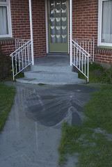
BeckerFraserPhotos November 2010 photograph 01
Images, UC QuakeStudies
Colombo Street south from the Moorhouse Avenue overbridge. Plastic and wire fencing has been used to cordon off damaged buildings and make a path for cars.
22 February Earthquake - Photograph 41
Images, UC QuakeStudies
A man inspects damage to his garden. Liquefaction and cracking can be seen on the path and lawn. The photographer comments, "Lateral spreading and liquefaction".
BeckerFraserPhotos February 2011 photograph 344
Images, UC QuakeStudies
Emergency tape reading, "Danger keep out" that has been blocking the garden path of a house on Galbraith Avenue in Avonside. It has come loose.
BeckerFraserPhotos March 2011 photograph 255
Images, UC QuakeStudies
Badly cracked stone steps on a path to The Spur from Nayland Street in Clifton. Rocks from the retaining wall have fallen onto the footpath.
BeckerFraserPhotos September 2011 photograph 017
Images, UC QuakeStudies
Photograph captioned by BeckerFraserPhotos, "A fallen brick fence post holding up a plywood fence to block access to an unsafe path in Winchester Street, Lyttelton".
BeckerFraserPhotos February 2011 photograph 029
Images, UC QuakeStudies
The cracked garden path of a house on Charles Street in Kaiapoi. A section of the fence has completely broken away from the post it was attached to.
QuakeStory Photo 371
Images, UC QuakeStudies
A photograph submitted by Scott Thomas to the QuakeStories website. The description reads, "The site that greeted me when I finally managed to beat a path to the washhouse on 24 February 2011.".
Canterbury Earthquake September 2010 - Photograph 19
Images, UC QuakeStudies
A large crack runs through the garden of a house in Richmond. The photographer comments, "A large crack about 15cm wide runs across three sections. Note the movement in the slabs for the garden path".
BeckerFraserPhotos September 2010 photograph 129
Images, UC QuakeStudies
The footpath in front of a building on Williams Street. As the building subsided it took part of the path with it. This gives an idea of how much this commercial building sank due to liquefaction.
Canterbury Earthquake September 2010 - Photograph 18
Images, UC QuakeStudies
A large crack runs through the garden of a house in Richmond. The photographer comments, "A large crack about 15cm wide runs across three sections. Note the movement in the slabs for the garden path".
BeckerFraserPhotos March 2012 photograph 287
Images, UC QuakeStudies
Photograph captioned by BeckerFraserPhotos, "The reflection of the Novotel Hotel in Cathedral Square in the PricewaterhouseCoopers Building on Armagh Street. This reflection is now possible as six buildings in the path have been demolished".
Crack'd for Christchurch Photograph 190
Images, UC QuakeStudies
A photograph of the location of the Green Room garden on Colombo Street. White picket fences have been placed around the edges of the site and a platform has been constructed in the back-right corner. Two garden plots have been sectioned off using bricks to the right and front of the site. The front plot has been planted with shrubs and grass. A path leading between the gardens up to the platform has been filled with gravel. Wire fences have been placed around the entire section as a cordon.Crack'd for Christchurch comments, "The Green Room was built by Jonathan Hall and planted by Gina Payne."
BeckerFraserPhotos November 2011 photograph 302
Images, UC QuakeStudies
Photograph captioned by BeckerFraserPhotos, "Horseshoe Lake area of Burwood has that name because a loop of the Avon River encircled it in a horseshoe shape. There used to be an attractive walk alongside the loop of the River. Much of the path is now under water as the land level has subsided as a result of the earthquakes".
Crack'd for Christchurch Plan 05
Images, UC QuakeStudies
A digital copy of a plan for the Greening the Rubble Green Room garden on Colombo Street. The plan shows a sketch of the garden including a raised floor, flower beds, a paved path, and a picket fence. It also contains measurements and notes on what will be planted in the beds.
Paul and Sam Corliss's Street Art Photograph (2015:02:20 13:46:58)
Images, UC QuakeStudies
A photograph of street art in the central city. The artwork depicts an excited blue alien positioned next to the letters "DTR!". Next to that, is artwork depicting Doctor Who and his Tardis. Above, is pink tag text with a Dalek in it. A section of the path in front of the artwork is sectioned off by road barriers.
Ground Motion Simulation Validation using Small-to-Moderate Magnitude Even…
Research papers, University of Canterbury Library
This poster presents work to date on ground motion simulation validation and inversion for the Canterbury, New Zealand region. Recent developments have focused on the collection of different earthquake sources and the verification of the SPECFEM3D software package in forward and inverse simulations. SPECFEM3D is an open source software package which simulates seismic wave propagation and performs adjoint tomography based upon the spectral-element method. Figure 2: Fence diagrams of shear wave velocities highlighting the salient features of the (a) 1D Canterbury velocity model, and (b) 3D Canterbury velocity model. Figure 5: Seismic sources and strong motion stations in the South Island of New Zealand, and corresponding ray paths of observed ground motions. Figure 3: Domain used for the 19th October 2010 Mw 4.8 case study event including the location of the seismic source and strong motion stations. By understanding the predictive and inversion capabilities of SPECFEM3D, the current 3D Canterbury Velocity Model can be iteratively improved to better predict the observed ground motions. This is achieved by minimizing the misfit between observed and simulated ground motions using the built-in optimization algorithm. Figure 1 shows the Canterbury Velocity Model domain considered including the locations of small-to-moderate Mw events [3-4.5], strong motion stations, and ray paths of observed ground motions. The area covered by the ray paths essentially indicates the area of the model which will be most affected by the waveform inversion. The seismic sources used in the ground motion simulations are centroid moment tensor solutions obtained from GeoNet. All earthquake ruptures are modelled as point sources with a Gaussian source time function. The minimum Mw limit is enforced to ensure good signal-to-noise ratio and well constrained source parameters. The maximum Mw limit is enforced to ensure the point source approximation is valid and to minimize off-fault nonlinear effects.
Strong Ground Motion Simulations for Dunedin: First Steps using the SCEC B…
Research papers, University of Canterbury Library
Our poster will present on-going QuakeCoRE-founded work on strong motion seismology for Dunedin-Mosgiel area, focusing on ground motion simulations for Dunedin Central Business District (CBD). Source modelling and ground motion simulations are being carried out using the SCEC (Southern California Earthquakes Center) Broad Band simulation Platform (BBP). The platform computes broadband (0-10 Hz) seismograms for earthquakes and was first implemented at the University of Otago in 2016. As large earthquakes has not been experienced in Dunedin in the time of period of instrumental recording, user-specified scenario simulations are of great value. The Akatore Fault, the most active fault in Otago and closest major fault to Dunedin, is the source focused on in the present study. Simulations for various Akatore Fault source scenarios are run and presented. Path and site effects are key components considered in the simulation process. A 1D shear wave velocity profile is required by SCEC BBP, and this is being generated to represent the Akatore-to-CBD path and site within the BBP. A 3D shear velocity model, with high resolution within Dunedin CBD, is being developed in parallel with this study (see Sangster et al. poster). This model will be the basis for developing a 3D shear wave velocity model for greater Dunedin-Mosgiel area for future ground motion simulations, using Canterbury software (currently under development).
Ground motion simulation validation with explicit uncertainty incorporatio…
Research papers, University of Canterbury Library
This study explicitly investigates uncertainties in physics-based ground motion simulation validation for earthquakes in the Canterbury region. The simulations utilise the Graves and Pitarka (2015) hybrid methodology, with separately quantified parametric uncertainties in the comprehensive physics and simplified physics components of the model. The study is limited to the simulation of 148 small magnitude (Mw 3.5 – 5) earthquakes, with a point source approximation for the source rupture representations, which also enables a focus on a small number of relevant uncertainties. The parametric uncertainties under consideration were selected through sensitivity analysis, and specifically include: magnitude, Brune stress parameter and high frequency rupture velocity. Twenty Monte Carlo realisations were used to sample parameter uncertainties for each of the 148 events. Residuals associated with the following intensity measures: spectral acceleration, peak ground velocity, arias intensity and significant duration, were ascertained. Using these residuals, validation was performed through assessment of systematic biases in site and source terms from mixed-effects regression. Based on the results to date, initial standard deviation recommendations for parameter uncertainties, based on the Canterbury simulations have been obtained. This work ultimately provides an initial step toward explicit incorporation of modelling uncertainty in simulated ground motion predictions for future events, which will improve the use of simulation models in seismic hazard analysis. We plan to subsequently assess uncertainties for larger magnitude events with more complex ruptures, and events across a larger geographic region, as well as uncertainties due to path attenuation, site effects, and more general model epistemic uncertainties.
Urban comfort in a future compact city: Analysis of open-space qualities i…
Research papers, Lincoln University
The increase in urban population has required cities to rethink their strategies for minimising greenhouse gas impacts and adapting to climate change. While urban design and planning policy have been guided by principles such as walkability (to reduce the dependence on cars) and green infrastructure (to enhance the quality of open spaces to support conservation and human values), there have been conflicting views on what spatial strategies will best prepare cities for a challenging future. Researchers supporting compact cities based upon public Transit Oriented Development have claimed that walkability, higher density and mixed-uses make cities more sustainable (Owen, 2009) and that, while green spaces in cities are necessary, they are dull in comparison with shopfronts and street vendors (Speck, 2012, p 250). Other researchers claim that green infrastructure is fundamental to improving urban sustainability and attracting public space users with improved urban comfort, consequently encouraging walkability (Pitman and Ely, 2013). Landscape architects tend to assume that ‘the greener the better’; however, the efficiency of urban greenery in relation to urban comfort and urbanity depends on its density, distribution and the services provided. Green infrastructure can take many forms (from urban forests to street trees) and provide varied services (amended microclimate, aesthetics, ecology and so forth). In this paper, we evaluate the relevance of current policy in Christchurch regarding both best practice in green infrastructure and urban comfort (Tavares, 2015). We focus on the Christchurch Blueprint for rebuilding the central city, and critically examine the post-earthquake paths the city is following regarding its green and grey infrastructures and the resulting urban environment. We discuss the performance and appropriateness of the current Blueprint in post-earthquake Christchurch, particularly as it relates to the challenges that climate change is creating for cities worldwide.
Investigating User-Centric Post-Earthquake Functional Recovery of Commerci…
Research papers, The University of Auckland Library
Past earthquakes have consistently highlighted the vulnerabilities of the built environment. Current building codes, which focus primarily on life safety, fail to address the need for buildings to remain functional after a seismic event. The emerging concept of post-earthquake functional recovery aims to integrate recovery-based objectives into building codes. However, literature reveals a predominant focus on engineering parameters, with limited attention given to the perspectives of building users; a critical gap in understanding a building’s comprehensive functionality and path to functional recovery. Whilst structural integrity is essential, functionality following a disaster is not determined by physical stability alone. Thus, this study addresses this gap by exploring the perceptions and expectations of office building users (both tenants and property owners) regarding building functionality and post-earthquake functional recovery in New Zealand’s major urban centres: Wellington, Auckland, and Christchurch. A qualitative research strategy was employed, utilising interpretative phenomenological and grounded theory methods to develop insights from the lived experiences of twenty-six (26) participants. The study applied a systems thinking approach using a socio-technical systems (STS) framework to develop micro (single construct) and macro (multiple constructs) models of building-system functionality. The findings demonstrate that a building’s functionality is nuanced, multifaceted, and context dependent. It encompasses physical, economic, social, organisational, technical, regulatory, and environmental elements, and is ultimately determined by users’ specific needs and priorities. A key divergence emerged: whilst property owners prioritise economic and environmental factors, tenants focus on the socio-organisational aspect, viewing the physical workspace as an embodiment of corporate identity, culture, and values. Regarding expectations for post-earthquake functional recovery, the post-pandemic era has drastically reshaped outlooks. Unlike previous earthquakes, where tenants scrambled for any available space, there is now increased demand for flexibility due to the hybrid work model. The immediate return to an office following a major earthquake is now expected to support critical business functions, with essential services including power or a standby generator, technology to access files, water, as well as operations of air conditioning and elevators. By advancing socio-technical systems theory and elucidating building users’ perspectives for a building’s functionality and post-disaster functional recovery, this research provides evidence-based, social science insights to inform more holistic and effective risk governance in property and disaster risk management