
Search
found 986 results
Images for digital; more images...


Digital Photograph: Exterior of Christchurch Chinese Methodist Church
Images, Canterbury Museum
One landscape colour digital photograph taken on 6 September 2010 showing earthquake damage to the red brick building of the Christchurch Chinese Methodist Church, 165 Papanui Road. The Christchurch Chinese Methodist Church on Papanui Road sustained severe damage during the 4 September 2010 earthquake. The red placards placed on the door of the...
Digital Photograph: Exterior of Christchurch Chinese Methodist Church
Images, Canterbury Museum
One landscape colour digital photograph taken on 6 September 2010 showing earthquake damage and a red placard on the red brick building of the Christchurch Chinese Methodist Church, 165 Papanui Road. The Christchurch Chinese Methodist Church on Papanui Road sustained severe damage during the 4 September 2010 earthquake. The red placards placed ...
Digital Photograph: Sign Advertising Whakahorohoro Ceremony in Lyttelton
Images, Canterbury Museum
One portrait colour digital photograph taken on 8 June 2011 of a sign advertising a Whakahorohoro Ceremony in Lyttelton. The sign is a printed piece of paper which has been laminated and attached to the fence on the site of Ground Delicatessen on the corner of London and Canterbury Streets. The cleared site is visible through the fence in the ba...
At Rainbow's End
Images, UC QuakeStudies
A digitally manipulated image of building rubble.
Digital Photograph: Earthquake damage to the old Vicarage, Lyttelton
Images, Canterbury Museum
One landscape colour digital photograph taken on 25 February 2011 showing the damage to the former Anglican Vicarage on Ripon Street Lyttelton. Taken from the footpath. Architect The sense of loss felt when confronted with the collapse or demolition of an historic building is compounded when that building is also a home. While the community sees...
Digital Photograph: Painting on Retaining Wall, The Gravy Train
Images, Canterbury Museum
One landscape colour digital photograph taken on 28 April 2012 showing a painting of a steam train with seven visible carriages or wagons. A caption painted below the train reads "The Gravy Train" The painting was executed in blue on large curved concrete blocks of a temporary retaining wall in Cunningham Terrace, Lyttelton. The retaining walls...
Digital Photograph: Earthquake damage to the Lyttelton Timeball Station
Images, Canterbury Museum
One landscape colour digital photograph taken on 25 February 2011 showing earthquake damage to the Lyttelton Timeball Station. Also visible is damage to some of the houses in the foreground such as temporarily patched holes in roofs where chimneys have fallen. Architect The Lyttelton Timeball Station was completed in 1876. Its function was to p...
Digital Photograph: Earthquake damage to the Lyttelton Timeball Station.
Images, Canterbury Museum
One landscape colour digital photograph taken on 16 June 2011 showing the eastern skyline of Lyttelton without the tower of the Timeball Station and Signal Mast. Part of the ground floor remains visible. The Holcim Cement Silos and Lyttelton Port of Christchurch log storage yard are visible in the foreground. Photograph taken from Oxford Street...
Digital Photograph: Corner of London and Canterbury Streets, Lyttelton
Images, Canterbury Museum
One landscape colour digital photograph taken on 19 November 2011 showing the site of the Albion Hotel/ Ground Delicatessen. After the demolition of the building the site was used for a Gap Filler initiative called the Lyttelton Petanque Club. The photograph shows the temporary furniture, landscaping and public Petanque court. The site formerl...
Digital Photograph: Corner of London and Canterbury Streets, Lyttelton
Images, Canterbury Museum
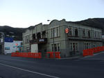
One landscape colour digital photograph taken on 19 November 2011 showing the corner of London and Canterbury Streets. Visible in the photograph (left to right) are the Lyttelton Library, Freemans Dining Room, Ray White Real Estate and Min Sargison Real Estate on London Street. The photograph is looking to the southeast. The site of the Timebal...
Digital Photograph: Earthquake damage to searchlight emplacements, Godley …
Images, Canterbury Museum
One landscape colour digital photograph taken on 26 May 2013 showing the southern cliffs of Godley Head. Taken from the middle of the shipping channel. Some earthquake damage to the cliffs is visible. There were several major rock falls along the coastal cliffs near Christchurch and Lyttelton Harbour. At Godley Head these caused damage to the W...
Digital Photograph: Corner of London and Oxford Streets, Lyttelton
Images, Canterbury Museum
One landscape colour digital photograph taken on 19 November 2011 showing the site of the old Lyttelton Library, Council Chambers and Magistrates' Court on the corner of Oxford Street and Sumner Road. At the time of the 22 February 2011 Earthquake the building was in private ownership and was the premises of Moda Fotografica and a private resid...
Digital Photograph: Sign Advertising a Matariki celebration in Lyttelton
Images, Canterbury Museum
One portrait colour digital photograph taken on 8 June 2011 of a sign advertising Matariki Celebrations in Lyttelton. The sign is a printed piece of paper which has been laminated and attached to the fence on the site of the Volcano Restaurant on the corner of London and Canterbury Streets. The cleared site is visible through the fence in the ba...
Digital Photograph: Demolition of Coastal Living, London Street, Lyttelton
Images, Canterbury Museum
One portrait colour digital photograph taken on 15 April 2011 showing the demolition of Coastal Living Design Store on London Street. This photograph shows the building's flagpole being salvaged for the building owner during the demolition. Also visible are the stock and shop fittings which were unable to be retrieved. In Christchurch's Centra...
Digital Photograph: Demolition of Coastal Living, London Street, Lyttelton
Images, Canterbury Museum
One landscape colour digital photograph taken on 15 April 2011 showing the demolition of Coastal Living Design Store on London Street. In Christchurch's Central Business District many of the high profile demolitions took place out of public view in the Red Zone. By contrast, the demolitions on London Street after the 22 February 2011 earthquake...
Digital Photograph: Earthquake damage to the Lyttelton Timeball Station.
Images, Canterbury Museum
One landscape colour digital photograph taken on 16 June 2011 showing the site of the Timeball Station after its collapse. Part of the ground floor remains visible. Photograph taken from Oxford Street Overbridge. Architect The 13 June 2011 earthquakes caused the collapse of the already damaged Lyttelton Timeball Station. After the 22 February ...
Digital Photograph: Earthquake damage to a retaining wall, Lyttelton
Images, Canterbury Museum
One landscape colour digital photograph taken on 30 June 2011 showing earthquake damage to a section of retaining wall in Sumner Road. Plastic sheeting installed to stabilise previous damage and protect from water erosion is visible to the right of the photograph. Also visible in the photograph is a boarded up broken window and temporary safety ...
Digital technologies and material culture in post-earthquake Christchurch
Research papers, University of Canterbury Library
There is a now a rich literature on the connections between digital media, networked computing, and the shaping of urban material cultures. Much less has addressed the post-disaster context, like we face in Christchurch, where it is more a case of re-build rather than re-new. In what follows I suggest that Lev Manovich’s well-known distinction between narrative and database as distinct but related cultural forms is a useful framework for thinking about the Christchurch rebuild, and perhaps urbanism more generally.
Assessing seismic collapse of structures using digital cloning techniques.
Research papers, University of Canterbury Library
Rapid, reliable information on earthquake-affected structures' current damage/health conditions and predicting what would happen to these structures under future seismic events play a vital role in accelerating post-event evaluations, leading to optimized on-time decisions. Such rapid and informative post-event evaluations are crucial for earthquake-prone areas, where each earthquake can potentially trigger a series of significant aftershocks, endangering the community's health and wealth by further damaging the already-affected structures. Such reliable post-earthquake evaluations can provide information to decide whether an affected structure is safe to stay in operation, thus saving many lives. Furthermore, they can lead to more optimal recovery plans, thus saving costs and time. The inherent deficiency of visual-based post-earthquake evaluations and the importance of structural health monitoring (SHM) methods and SHM instrumentation have been highlighted within this thesis, using two earthquake-affected structures in New Zealand: 1) the Canterbury Television (CTV) building, Christchurch; 2) the Bank of New Zealand (BNZ) building, Wellington. For the first time, this thesis verifies the theoretically- and experimentally validated hysteresis loop analysis (HLA) SHM method for the real-world instrumented structure of the BNZ building, which was damaged severely due to three earthquakes. Results indicate the HLA-SHM method can accurately estimate elastic stiffness degradation for this reinforced concrete (RC) pinched structure across the three earthquakes, which remained unseen until after the third seismic event. Furthermore, the HLA results help investigate the pinching effects on the BNZ building's seismic response. This thesis introduces a novel digital clone modelling method based on the robust and accurate SHM results delivered by the HLA method for physical parameters of the monitored structure and basis functions predicting the changes of these physical parameters due to future earthquake excitations. Contrary to artificial intelligence (AI) based predictive methods with black-box designs, the proposed predictive method is entirely mechanics-based with an explicitly-understandable design, making them more trusted and explicable to stakeholders engaging in post-earthquake evaluations, such as building owners and insurance firms. The proposed digital clone modelling framework is validated using the BNZ building and an experimental RC test structure damaged severely due to three successive shake-table excitations. In both structures, structural damage intensifies the pinching effects in hysteresis responses. Results show the basis functions identified from the HLA-SHM results for both structures under Event 1 can online estimate structural damage due to subsequent Events 2-3 from the measured structural responses, making them valuable tool for rapid warning systems. Moreover, the digital twins derived for these two structures under Event 1 can successfully predict structural responses and damage under Events 2-3, which can be integrated with the incremental dynamic analysis (IDA) method to assess structural collapse and its financial risks. Furthermore, it enables multi-step IDA to evaluate earthquake series' impacts on structures. Overall, this thesis develops an efficient method for providing reliable information on earthquake-affected structures' current and future status during or immediately after an earthquake, considerably guaranteeing safety. Significant validation is implemented against both experimental and real data of RC structures, which thus clearly indicate the accurate predictive performance of this HLA-based method.
Gap Filler
Images, UC QuakeStudies
A digitally manipulated photograph of the Gap Filler logo.
Unsafe
Images, UC QuakeStudies
A digitally manipulated photograph of a 'Danger, Keep Clear' sign.
Lemon and Lime
Images, UC QuakeStudies
A digitally manipulated photograph of a stack of metal beams.
Photograph number UC 11-0456-03
Images, UC QuakeStudies
Launch function for the UC CEISMIC digital archive at the museum.
Photograph number UC 11-0456-01
Images, UC QuakeStudies
Launch function for the UC CEISMIC digital archive at the museum.
Another Day and Another Deconstruction
Images, UC QuakeStudies
A digitally manipulated image of damaged buildings on St Asaph Street.
Photograph number UC 11-0456-02
Images, UC QuakeStudies
Launch function for the UC CEISMIC digital archive at the museum.
Photograph of Gap Filler project 22 (106)
Images, UC QuakeStudies
A digitally altered photograph of the inside of the Pallet Pavilion.
From film to Web 2.0: transmedia as a distribution model for political doc…
Research papers, The University of Auckland Library
This research is a creative exploration of transmedia’s ability to offer up a model of distribution and audience engagement for political documentary. Transmedia, as is well known, is a fluid concept. It is not restricted to the activities of the entertainment industry and its principles also reverberate in the practice of political and activist documentary projects. This practice-led research draws on data derived from the production and circulation of Obrero, an independent transmedia documentary. The project explores the conditions and context of the Filipino rebuild workers who migrated to Christchurch, New Zealand after the earthquake in 2011. Obrero began as a film festival documentary that co-exists with two other new media iterations, each reaching its respective target audience: a web documentary, and a Facebook-native documentary. This study argues that relocating the documentary across new media spaces not only expands the narrative but also extends the fieldwork and investigation, forms like-minded publics, and affords the creation of an organised hub of information for researchers, academics and the general public. Treating documentary as research can represent a novel pathway to knowledge generation and the present case study, overall, provides an innovative model for future scholarship.
Digital Photograph: Earthquake Damage to Road on Norwich Quay, Lyttelton
Images, Canterbury Museum
One landscape colour digital photograph taken on 25 February 2011 showing earthquake damage to the road, footpath and retaining wall on Norwich Quay. The photograph is taken from below the intersection of Norwich Quay and Canterbury Street looking east along Norwich Quay. Unlike most areas of Christchurch, land damage on the Port Hills was due ...
Digital Photograph: Helicopter with Monsoon Bucket washing away unstable r…
Images, Canterbury Museum
One portrait colour digital photograph taken on 25 February 2011 showing a helicopter using a monsoon bucket to wash away unstable rocks from cliffs behind the Lyttelton Container Terminal. One of the immediate priorities in Lyttelton was stabilising the transport routes both from Lyttelton to Christchurch and the port infrastructure so that go...