Search
found 196 results
Images for New Zealand; more images...


Building resilience in transient rural communities – a post-earthquake reg…
Research papers, Lincoln University
The Kaikoura earthquake in November 2016 highlighted the vulnerability of New Zealand’s rural communities to locally-specific hazard events, which generate regional and national scale impacts. Kaikoura was isolated with significant damage to both the east coast road (SH1) and rail corridor, and the Inland Road (Route 70). Sea bed uplift along the coast was significant – affecting marine resources and ocean access for marine operators engaged in tourism and harvesting, and recreational users. While communities closest to the earthquake epicentre (e.g., Kaikoura, Waiau, Rotherham and Cheviot) suffered the most immediate earthquake damage, the damage to the transport network, and the establishment of an alternative transport route between Christchurch and Picton, has significantly impacted on more distant communities (e.g., Murchison, St Arnaud and Blenheim). There was also considerable damage to vineyard infrastructure across the Marlborough region and damage to buildings and infrastructure in rural settlements in Southern Marlborough (e.g., Ward and Seddon).
Impacts of the 14th November 2016 Kaikōura Earthquake on three waters sys…
Research papers, University of Canterbury Library
We present preliminary observations on three waters impacts from the Mw7.8 14th November 2016 Kaikōura Earthquake on wider metropolitan Wellington, urban and rural Marlborough, and in Kaikōura township. Three waters systems in these areas experienced widespread and significant transient ground deformation in response to seismic shaking, with localised permanent ground deformation via liquefaction and lateral spreading. In Wellington, potable water quality was impacted temporarily by increased turbidity, and significant water losses occurred due to damaged pipes at the port. The Seaview and Porirua wastewater treatment plants sustained damage to clarifier tanks from water seiching, and increased water infiltration to the wastewater system occurred. Most failure modes in urban Marlborough were similar to the 2010-2011 Canterbury Earthquake Sequence; however some rural water tanks experienced rotational and translational movements, highlighting importance of flexible pipe connections. In Kaikōura, damage to reservoirs and pipes led to loss of water supply and compromised firefighting capability. Wastewater damage led to environmental contamination, and necessitated restrictions on greywater entry into the system to minimise flows. Damage to these systems necessitated the importation of tankered and bottled water, boil water notices and chlorination of the system, and importation of portaloos and chemical toilets. Stormwater infrastructure such as road drainage channels was also damaged, which could compromise condition of underlying road materials. Good operational asset management practices (current and accurate information, renewals, appreciation of criticality, good system knowledge and practical contingency plans) helped improve system resilience, and having robust emergency management centres and accurate Geographic Information System data allowed effective response coordination. Minimal damage to the wider built environment facilitated system inspections. Note Future research will include detailed geospatial assessments of seismic demand on these systems and attendant modes of failure, levels of service restoration, and collaborative development of resilience measures.
Post-earthquake decision-making on sewer recovery and the roles of damage …
Research papers, University of Canterbury Library
Decision making on the reinstatement of the Christchurch sewer system after the Canterbury (New Zealand) earthquake sequence in 2010–2011 relied strongly on damage data, in particular closed circuit television (CCTV). This paper documents that process and considers how data can influence decision making. Data are analyzed on 33,000 pipes and 13,000 repairs and renewals. The primary findings are that (1) there should be a threshold of damage per pipe set to make efficient use of CCTV; (2) for those who are estimating potential damage, care must be taken in direct use of repair data without an understanding of the actual damage modes; and (3) a strong correlation was found between the ratio of faults to repairs per pipe and the estimated peak ground velocity. Taken together, the results provide evidence of the extra benefit that damage data can provide over repair data for wastewater networks and may help guide others in the development of appropriate strategies for data collection and wastewater pipe decisions after disasters.
On-going challenges in physics-based ground motion prediction and insights…
Research papers, University of Canterbury Library
This paper presents on-going challenges in the present paradigm shift of earthquakeinduced ground motion prediction from empirical to physics-based simulation methods. The 2010-2011 Canterbury and 2016 Kaikoura earthquakes are used to illustrate the predictive potential of the different methods. On-going efforts on simulation validation and theoretical developments are then presented, as well as the demands associated with the need for explicit consideration of modelling uncertainties. Finally, discussion is also given to the tools and databases needed for the efficient utilization of simulated ground motions both in specific engineering projects as well as for near-real-time impact assessment.
The Week In Review for week ending Fri Feb 3 2017
Audio, Radio New Zealand
A review of the week's news including... a major health alert in Pukekohe after two and a half thousand children were exposed to contaminated water, the Prime Minister kicks off election year with a pledge to spend more than half a billion dollar on crime-fighting, is New Zealand citizenship for sale? several former employees of the Canterbury Earthquake Recovery Authority are being investigated, international Indian students to be deported, more alleged mistreatment of animals revealed at another New Zealand rodeo event, a women's sexual abuse group says the judge got it wrong when he ruled in favour of a man who posted photos of his half naked wife on Facebook, people increasingly find ways to get around petrol prices that they think are too high, should an unofficial white chair memorial to the victims of the 2011 Christchurch quake be moved? the scientific test results which reveal exactly how Havelock North's drinking water supply was contaminated, the Maori Party backs calls from a group of local councils campaigning to keep their regions free from genetic modification, a film producer is caught out by a recent law change banning anyone travelling from America from entering New Zealand with medicinal cannabis and an update on a seriously unwell albatross chick.
Old Christchurch stadium seats sold off
Audio, Radio New Zealand
Work has finally begun dismantling Lancaster Park in Christchurch, six years after it was damaged beyond repair in the February earthquake. It comes at the same time the city's leaders debate what a new stadium could look like and who will pay.
Extreme landscapes: A 21st century sublime
Research papers, Lincoln University
Queenstown and Christchurch are twin poles of New Zealand's landscape of risk. As the country's 'adventure capital', Queenstown is a spectacular landscape in which risk is a commodity. Christchurch's landscape is also risky, ruptured by earthquakes, tentatively rebuilding. As a far-flung group of tiny islands in a vast ocean, New Zealand is the poster-child of the sublime. Queenstown and Christchurch tell two different, yet complementary, stories about the sublime. Christchurch and Queenstown are vehicles for exploring the 21st-century sublime, for reflecting on its expansive influence on shaping cultural landscapes. Christchurch and Queenstown stretch and challenge the sublime's influence on the designed landscape. Circling the paradoxes of risk and safety, suffering and pleasure, the sublime feeds an infinite appetite for fear as entertainment, and at the same time calls for an empathetic caring for a broken landscape and its residents.
Fault rupture patterns during the Mw7.8 2016 Kaikoura Earthquake in the re…
Research papers, University of Canterbury Library
Surface rupture and slip from the Mw 7.8 2016 Kaikōura Earthquake have been mapped in the region between the Leader and Charwell rivers using field mapping and LiDAR data. The eastern Humps, north Leader and Conway-Charwell faults ruptured the ground surface in the study area. The E-NE striking ‘The Humps’ Fault runs along the base of the Mt Stewart range front, appears to dip steeply NW and intersects the NNW-NNE Leader Fault which itself terminates northwards at the NE striking Conway-Charwell Fault. The eastern Humps Fault is up to the NW and accommodates oblique slip with reverse and right lateral displacement. Net slip on ‘The Humps’ Fault is ≤4 m and produced ≤4 m uplift of the Mt Stewart range during the earthquake. The Leader Fault strikes NNW-NNE with dips ranging from ~10° west to 80° east and accommodated ≤4 m net slip comprising left-lateral and up-to-the-west vertical displacement. Like the Humps west of the study area, surface-rupture of the Leader Fault occurred on multiple strands. The complexity of rupture on the Leader Fault is in part due to the occurrence of bedding-parallel slip within the Cretaceous-Cenozoic sequence. Although the Mt Stewart range front is bounded by ‘The Humps’ Fault, in the study area neither this fault nor the Leader Fault were known to have been active before the earthquake. Fieldwork and trenching investigations are ongoing to characterise the geometry, kinematics and paleoseismic history of the mapped active faults.
"Once you move, it's a different story" : the meaning of home for 1.5 gene…
Research papers, University of Canterbury Library
While some scholarship on refugee youth has focussed on leaving a place that is typically considered ‘home,’ there has been little attention to what ‘home’ means to them and how this is negotiated in the country of (re)settlement. This is particularly the case for girls and women. New Zealand research on refugee settlement has largely focussed on the economic integration of refugees. Although this research is essential, it runs the risk of overlooking the socio-cultural aspects of the resettlement experiences and renders partial our understanding of how particular generations and ethnic groups develop a sense of belonging to their adopted homeland. In order to address these research gaps, this thesis explores the experiences of 12 Afghan women, aged 19-29 years, of refugee background who relocated to Christchurch, New Zealand, during their childhood and early teenage years. This study employed semi-structured, one-to-one, in-depth interviews and photo-elicitation to encourage talk about participants’ experiences of leaving Afghanistan, often living in countries of protracted displacement (Iran and/or Pakistan) and making- and being-at-home in New Zealand. In this thesis, I explore the ways in which they frame Afghanistan, and the ways in which their experiences in Iran and Pakistan disrupt the dichotomisation of belonging in terms of ‘here’ (ancestral land) and ‘there’ (country of residence). Furthermore, I use affect theorising to analyse the participants’ expressions of resettlement and home in New Zealand. Feeling at home is as much about negotiating cultural and gendered identities in Western secular societies as it is about belonging to a particular community. Through their experiences of ‘living in two worlds’, the participants are able to strategically challenge cultural expectations without undermining their reputations as Muslims and as Afghan women. The participants discussed their emotional responses to double-displacement: one as a result of war and the other as a result of 2011 Canterbury earthquakes. Therefore, I suggest that for young Afghan women, Afghanistan was among several markers of home in a long embodied journey of (re)settlement.
Sign of the Kiwi re-opens in Christchurch - locals delight
Audio, Radio New Zealand
Built in June 1917, the popular 'Sign of the Kiwi' heritage building in Christchurch's Port Hills has re-opened today after being closed for six years due to earthquake damage.
Phoenix Rising
Audio, Radio New Zealand
The Christchurch earthquakes caused devastating damage to many of the city’s creative spaces. But rising from the rubble has been the Isaac Theatre Royal under the watchful eye of Neil Cox. He’s directed the resurrection of one of the premiere performance spaces in the country.
Earthquake survivor says Wgtn must cordon around unsafe sites
Audio, Radio New Zealand
A woman crushed to within milimetres of her life in the Christchurch earthquake says it is murderously cavalier for Wellington's council not to cordon off weak or prone buildings.
30,000 to watch Springsteen on eve of quake anniversary
Audio, Radio New Zealand
People have been queuing for days for the Bruce Springsteen concert in Christchurch tonight, ahead of the sixth anniversary of the 2011 earthquake. Glenn McCartney is at the front of the queue.
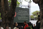
Memorial for quake victims to be revealed on 6th anniversary
Audio, Radio New Zealand
A memorial for the 185 people who died in the 2011 Christchurch earthquake will be blessed tonight, ahead of the unveiling tomorrow, on the sixth anniversary.
Bruce Springsteen fans queue for days ahead of SI show
Audio, Radio New Zealand
Some Bruce Springsteen fans have queued for days ahead of the Boss' show in Christchurch tomorrow night - on the eve of the sixth anniversary of the 2011 earthquake.
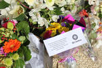
Families attend Chch earthquake memorial unveiling
Audio, Radio New Zealand
The Canterbury Earthquake National Memorial was unveiled to the public at a memorial attended by more than 3000 people.
Backpacker's family's first visit to Chch for quake memorial
Audio, Radio New Zealand
Rachel Conley's family has flown to Christchurch for the first time for the unveiling of the memorial wall. They are staying with a NZ family, whose son died along with Rachel in the earthquake.
Quakes, fires, insurance claims - and then a parking ticket
Audio, Radio New Zealand
Christchurch woman Pam Sharpe has endured earthquakes, fires and dealing with insurance companies, but then she received a parking ticket. She tells Checkpoint what happened next.
Chch councillor Raf Manji to take on Gerry Brownlee in Ilam
Audio, Radio New Zealand
Christchurch councillor Raf Manji announces plans to stand against Earthquake Minister Gerry Brownlee in Ilam at the general election. He tells John Campbell why he is standing as an independent.
North Canterbury locals struggling after Kaikoura quake
Audio, Radio New Zealand
Thirty properties are unlivable while another 170 have restricted access following the Kaikoura earthquake last year. RNZ reporter Conan Young reports from a town meeting.
Quake-hit North Canterbury farmers in need of accomodation
Audio, Radio New Zealand
Many farmers' homes have been red-stickered after the Kaikoura earthquake, but they say they can't leave because their farms aren't just their homes, they're their livelihoods
Truck drivers quit over safety fears
Audio, Radio New Zealand
More than five people have died on crashes on SH1 between Picton and Christchurch since it became a main arterial route following the Kaikoura earthquake.
CERA officials used positions for financial gain
Audio, Radio New Zealand
Two former Canterbury Earthquake Recovery Authority officials attempted to use their positions for their own financial gain and their actions will now be referred to the Serious Fraud Office.
Christchurch cleanup producing potentially toxic dust
Audio, Radio New Zealand
Medium-density fibreboard has been sitting at an old rubbish put in Wigram since the earthquakes and residents are worried it's harming their health.
Christchurch sitting on mental health 'time bomb'
Audio, Radio New Zealand
Dr Sue Bagshaw, the head of a youth health clinic Christchurch, fears the high rates of Post Traumatic Stress Disorder among children will skyrocket due to the earthquake.
Ministry apologises to Chch schools for handling of closures
Audio, Radio New Zealand
The Ministry of Education has been forced to apologise for its flawed handling of school closures and mergers after the 2011 Canterbury earthquake.
Music back at the Christchurch Town Hall
Audio, Radio New Zealand
For the first time in six years, music has filled Christchurch's Town Hall, which suffered significant damage in the February 2011 earthquake.
Heathcote family say EQC failed them
Audio, Radio New Zealand
A Christchurch family have found themselves stuck with a house that is too unsafe to live in after a fire revealed earthquake damage, which EQC admits it failed to identify.
Tiny temporary village opens in town hit by Kaikoura quake
Audio, Radio New Zealand
A temporary village has opened in the small Canterbury town of Waiau to help residents who lost their homes in the Kaikoura earthquake.
Gerry Brownlee acted 'unlawfully' over uninsured land, court rules
Audio, Radio New Zealand
The former Earthquake Recovery Minister's decision to exclude uninsured Canterbury landowners under the Recovery Plan was unlawful, the Court of Appeal has ruled in an interim judgement.