
Search
found 507 results
Images for F+; more images...


Christchurch Press 15 March 2014: Section F, Page 7
Articles, UC QuakeStudies
Page 7 of Section F of the Christchurch Press, published on Saturday 15 March 2014.
Christchurch Press 18 January 2014: Section F, Page 8
Articles, UC QuakeStudies
Page 8 of Section F of the Christchurch Press, published on Saturday 18 January 2014.
Christchurch Press 25 October 2014: Section F, Page 4
Articles, UC QuakeStudies
Page 4 of Section F of the Christchurch Press, published on Saturday 25 October 2014.
Christchurch Press 1 February 2014: Section F, Page 8
Articles, UC QuakeStudies
Page 8 of Section F of the Christchurch Press, published on Saturday 1 February 2014.
Christchurch Press 22 November 2014: Section F, Page 2
Articles, UC QuakeStudies
Page 2 of Section F of the Christchurch Press, published on Saturday 22 November 2014.
Christchurch Press 15 March 2014: Section F, Page 1
Articles, UC QuakeStudies
Page 1 of Section F of the Christchurch Press, published on Saturday 15 March 2014.
Christchurch Press 18 January 2014: Section F, Page 9
Articles, UC QuakeStudies
Page 9 of Section F of the Christchurch Press, published on Saturday 18 January 2014.
Christchurch Press 26 April 2014: Section F, Page 3
Articles, UC QuakeStudies
Page 3 of Section F of the Christchurch Press, published on Saturday 26 April 2014.
Christchurch Press 4 October 2014: Section F, Page 10
Articles, UC QuakeStudies
Page 10 of Section F of the Christchurch Press, published on Saturday 4 October 2014.
Christchurch Press 26 July 2014: Section F, Page 3
Articles, UC QuakeStudies
Page 3 of Section F of the Christchurch Press, published on Saturday 26 July 2014.
Performance of the Christchurch, New Zealand cathedral during the M7.1 201…
Research papers, The University of Auckland Library
The Catholic Cathedral is classified as a category 1 listed heritage building constructed largely of unreinforced stone masonry, and was significantly damaged in the recent Canterbury earthquakes of 2010 and 2011. In the 2010 event the building presented slight to moderta damage, meanwhile in the 2011 one experienced ground shaking in excess of its capacity leading to block failures and partial collapse of parts of the building, which left the building standing but still posing a significant hazard. In this paper we discuss the approach to develop the earthquake analysis of the building by 3D numerical simulations, and the results are compared/calibrated with the observed damage of the 2010 earthquake. Very accurate records were obtained during both earthquakes due to a record station located least than 80 m of distance from the building and used in the simulations. Moreover it is included in the model the soil structure interaction because it was observed that the ground and foundation played an important role on the seismic behavior of the structure. A very good agreement was found between the real observed damage and the nonlinear dynamic simulations described trough inelastic deformation (cracking) and building´s performance.
All Right? Newsletter: All Right? February update
Articles, UC QuakeStudies
A PDF copy of a newsletter sent by All Right? to their mailing list in February 2014.
Low frequency (f=1Hz) ground motion simulations of 10 events in the 2010-2…
Research papers, University of Canterbury Library
None
Modelling stormwater management options for enhancing water quality of urb…
Research papers, University of Canterbury Library
The majority of Christchurch’s stormwater has historically been discharged untreated directly into urban surface waterways. These receiving waterways have become adversely affected by the contaminants carried in the stormwater, particularly sediment and heavy metals. An event-based contaminant load model was developed to identify the distribution and magnitude of contaminant loads entering the waterway, as well as to assess the reduction in TSS and heavy metal loads that can be achieved by various stormwater management options. The GIS-Excel based model estimates contaminant loads from an individual storm event based on different contributing impervious surfaces and key rainfall characteristics (rainfall intensity, duration, pH and antecedent dry days). It then calculates contaminant reduction loads that could be achieved through source reduction (e.g. green roofs, repainting) as well as from treatment (e.g. raingardens, wet ponds) applied to different surfaces within the catchment. This model differs from other annual load models as it is event-based and accounts for storm characteristics in its calculation of contaminant loads. Christchurch is a valuable case setting due the unique opportunity for retrofitting improved stormwater management in the post-earthquake rebuild. It is anticipated that this modelling approach could later be adapted for use in other urban settings outside of Christchurch.
20140819_9054_EOS M-24 More infra-structure work!
Images, eqnz.chch.2010
More repairs to the infrastructure as a result of the 2010 & 2011 earthquakes. Boat ramp at New Brighton. Avon River.
20140819_9053_EOS M-26 More infra-structure work!
Images, eqnz.chch.2010
More repairs to the infrastructure as a result of the 2010 & 2011 earthquakes. Boat ramp at New Brighton. Avon River.
20140819_9079_EOS M-85 More infra-structure work!
Images, eqnz.chch.2010
More repairs to the infrastructure as a result of the 2010 & 2011 earthquakes. Hardy Street/Owles Terrace corner (beside the boat launching ramp), New Brighton
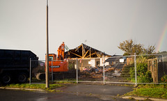
20140526_8961_EOS M-22 It is happening now
Images, eqnz.chch.2010
My house (bought in March 2004) till the government procured it in October 2012, is finally being demolished. It will be an empty section in a couple of days, once they rip up the concrete base. Note the rainbow on right.
20140904_9091_EOS M-22 23 Velsheda Street today (2014)
Images, eqnz.chch.2010
Today (04/09/14) marks the fourth anniversary since the first earthquake rocked the city and greater Christchurch area. That first quake was magnitude 7.1, and luckily there was only one fatality (possible a heart attack). Since then we have had over 14,000 quakes, most very small in magnitude, but well over 500 of magnitude 4 or greater. 5...
20140522_8951_EOS M-22 Demolition
Images, eqnz.chch.2010
20140522_8951_EOS M-22 Demolition Of what many in Christchurch know as the Millers building, but for many recent years was the home to the Christchurch City Council, till just a week or two before the first earthquake of 2010. Now, in mid-2014 it is finally being demolished after nearly 45 months empty. A bus is leaving the new (temporary) bu...
20140713_1533_1D3-40 Little left in Seabreeze Close
Images, eqnz.chch.2010
Looking across several properties to a yet to demolished (or possibly removed) house on Seabreeze Close, Pacific Park, Bexley.
20140112_7560_1D3-32 Graffiti book is open (SH 52)
Images, eqnz.chch.2010
Scavenger Hunt 101 - SH 52 (graffiti) Graffiti (or wall art) on the now visible side of a building in central Christchurch. There are still about 100 major buildings to be demolished in the city post the earthquakes.
20140110_7484_1D3-40 Avon River and earthquake damage
Images, eqnz.chch.2010
Low tide on the Avon River at New Brighton/Bexley. Note the original bank and the rock wall slipage on right. The white additions were added in March and April 2011 to protect the properties behind from flooding. Ultimately this area was "red zoned" with all houses removed or to be removed and the ground left till a rehabilitation method can ...
It has started!
Images, eqnz.chch.2010
20140521_1080_1D3-24 It has started! Removal of the double-glazed windows is underway at my "red zone" house, now owned by the Government of New Zealand. Sold to CERA (the government agency) in October 2012 and has remained empty since, despite having little damage, apart from the tilt to the front from the land damage that occurred during the...
20140927_2219_1D3-24 Planting natives at Harold Henry Park
Images, eqnz.chch.2010
20140927_2219_1D3-24 Planting natives at Harold Henry Park A planting of native bushes and trees in the old children's playground area in Bexley, Organised by the Facebook group Avon River Park and assisted by ex Bexley residents. This is right in the middle of the Bexley red zone with most houses removed or demolished now. #5832
20141005_2502_1D3-40 CTV site
Images, eqnz.chch.2010
The sign reads: The CTV Building was headquarters of Canterbury Television (CTV) and also housed King’s Education language School, a medical clinic, Hair Consultants, Relationship Services and a nursing school. On February 22nd 2011 the building collapsed as a result of a major earthquake. Sadly, 115 people who were in the building lost their l...
20140713_1530_1D3-40 A throne for a King? [Explored]
Images, eqnz.chch.2010
Another house has gone from Seabreeze Close, Pacific Park, Bexley, leaving just the concrete base, a few floor tiles and the smashed toilet (throne). Houses are being demolished (85%) or deconstructed/shifted (15%) as a result of land damage in the major earthquakes of 4th September 2010, 22nd February 2011, 13th June 2011 and 23rd December 2...