Search
found 4703 results
Images for houses; more images...
WEMO ERT Set 3 - February 2011 - Photograph 159
Images, UC QuakeStudies
A photograph of a member of the Wellington Emergency Management Office Emergency Response Team standing in front of the earthquake-damaged Avonmore House on Hereford Street. Sections of the walls have crumbled, spilling bricks and masonry onto the footpath and street below. Many of the windows have also warped, breaking the glass. USAR codes have been spray-painted on one of the columns. A red sticker taped to the door indicates that the building is unsafe to enter.
WEMO ERT Set 1 - March 2011 - Photograph 139
Images, UC QuakeStudies
A photograph of the earthquake damage to the Avonmore House on the corner of Hereford Street and Latimer Square. Large cracks have formed in the building, causing sections of the masonry to crumble. The windows on the Hereford Street side of the building have bent out of shape and many of the glass panes have shattered. USAR codes have been spray painted on the column next to the door. In the distance wire fencing has been placed across the street as a cordon.
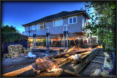
BeckerFraserPhotos June 2012 photograph 158
Images, UC QuakeStudies
Photograph captioned by BeckerFraserPhotos, "The Forsyth Barr building at 764 Colombo Street (left) and 779 Colombo Street (right)".
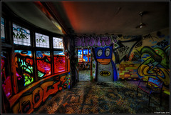
Paul and Sam Corliss's Street Art Photograph (2015:03:30 17:13:26)
Images, UC QuakeStudies
A photograph of a woman wearing overalls covered in paint. She is holding a spray-paint can in each of her hands. There is a painted wall depicting two tui behind her, with four more spray-paint cans on the ground in front of it.
Photograph by Paul Corliss 2566
Images, UC QuakeStudies
A photograph of documents taped to the door of 156 McCormacks Bay Road in Redcliffs. One of the documents is from the Christchurch City Council and reads, "Do not approach or enter this building".
Julia Holden's 2012 Photographs 119
Images, UC QuakeStudies
A photograph of an abandoned property at 72 Waitaki Street in Bexley. The driveway is flooded with stagnant water.
Julia Holden's 2012 Photographs 118
Images, UC QuakeStudies
A photograph of an abandoned property at 72 Waitaki Street in Bexley. The driveway is flooded with stagnant water.
The Ozone Now a No Zone
Images, UC QuakeStudies
Two diggers on top of a pile of rubble inside the partially demolished Ozone Dressing Sheds building. The photographer comments, "The Ozone must have suffered in the February earthquake more than people thought. They were starting to repaint it inside, but it looks like they must have run out of filler".
Julia Holden's 2012 Photographs 117
Images, UC QuakeStudies
A photograph of an abandoned property at 72 Waitaki Street in Bexley. The driveway is flooded with stagnant water.
Julia Holden's 2012 Photographs 111
Images, UC QuakeStudies
A photograph of an abandoned property at 72 Waitaki Street in Bexley. The driveway is flooded with stagnant water.
Carved Box: Knot in Rimu
Images, Canterbury Museum
One turned wooden box shaped like a teardrop, made from rimu. Inset brass and pewter strips curve around the base in a Celtic knot shape. The box is in two parts.
Artwork: Oh Deer, Who Will Lead Santa’s Sleigh?
Images, Canterbury Museum
One artwork in the shape of a stag's head, made from recycled copper and flattened corrugated iron. The item could be used as a coat hook.
BeckerFraserPhotos September 2011 photograph 399
Images, UC QuakeStudies
Photograph captioned by BeckerFraserPhotos, "Replica of Tui ad billboard on a house at 739 Gloucester Street. This one appeared during the Rugby World Cup".
BeckerFraserPhotos May 2013 photograph 039
Images, UC QuakeStudies
An abandoned residential property at 2 Seabreeze Close in Bexley. Weeds have grown through the cracks in the driveway and around the front of the house.
Photograph by Neil Macbeth 454
Images, UC QuakeStudies
A Civil Defence staff member placing a red sticker on the window of a damaged house. The sticker indicates that the building is unsafe to enter.
BeckerFraserPhotos April 2011 photograph 245
Images, UC QuakeStudies
A sign taped to the door of the Strategy building on Montreal Street. The sign reads, "Danger, your house has a red placard, do not enter".
BeckerFraserPhotos February 2011 photograph 296
Images, UC QuakeStudies
A house on Avonside Drive with cracks in its foundations and the interior wall of its porch as a result of the 4 September 2010 earthquake.
BeckerFraserPhotos October 2011 photograph 430
Images, UC QuakeStudies
Photograph captioned by BeckerFraserPhotos, "The remains of SBS House, on the south-east corner of Worcester and Manchester Streets. The Octagon Live is behind".
BeckerFraserPhotos May 2011 photograph 0017
Images, UC QuakeStudies
Fences surround two cleared sites at 15 and 17 Oxford Street in Lyttelton. The sites formerly housed Lyttelton Lounge cafe, The Opportunity Shop and NZ Souvenir.
BeckerFraserPhotos October 2010 photograph 093
Images, UC QuakeStudies
The driveway of a house on Avonside Drive. One of the concrete slabs has broken apart from another and lifted to create a gap between them.
BeckerFraserPhotos December 2011 photograph 2442
Images, UC QuakeStudies
A photograph captioned by BeckerFraserPhotos, "A house at 464 Avonside Drive in Avonside which has moved towards the river while the deck stayed put".
Jim Baltaxe WEMO Photograph 128
Images, UC QuakeStudies
A photograph of a red sticker on the wire fencing outside a house on Papanui Street. The sticker indicates that the building is unsafe to enter.
Christchurch Press Image: Dean Kozanic 2010:09:06 (02)
Images, UC QuakeStudies
Photograph captioned by Fairfax, "Aftermath of the earthquake in Christchurch where the cleanup has begun. Roy Smith's new house in Mundys Road, Dallington, has shifted severely".
Central City Tour, 4 April 2011 - Photograph 02
Images, UC QuakeStudies
Damage to a house in Richmond. Brick cladding is badly cracked and buckled, and some bricks have fallen. The photographer comments, "Brick walls still clinging on".
BeckerFraserPhotos May 2011 photograph 0021
Images, UC QuakeStudies
A colourful tarpaulin is draped over a hole in the Lyttelton Museum on Norwich Quay. The building was constructed in 1911 to house the Seamen's Institute.
BeckerFraserPhotos February 2011 photograph 212
Images, UC QuakeStudies
The driveway of a house on Bracken Street in Avonside that has been warped by earthquakes. Dry deposits of liquefaction can be seen on the driveway.
BeckerFraserPhotos February 2012 photograph 0116
Images, UC QuakeStudies
A photograph of a house in Burwood. The photograph is captioned by BeckerFraserPhotos, "Former home of the Pasfield Family, Kingsford Street, Horseshoe Lake, Burwood".
BeckerFraserPhotos February 2012 photograph 0090
Images, UC QuakeStudies
A photograph captioned by BeckerFraserPhotos, "New Brighton Road. The blinds here hang vertically and show how far the house has sunk on the right".
BeckerFraserPhotos May 2011 photograph 0020
Images, UC QuakeStudies
The top story of Fuze Restaurant and Cafe is dismantled by construction workers. The building formerly housed the Harbour Board offices, and was built in 1880.
BeckerFraserPhotos May 2013 photograph 088
Images, UC QuakeStudies
An empty section where a house once stood at 14 Waygreen Avenue in New Brighton. The section has become overgrown with weeds and the gutter has flooded.