Search
found 4703 results
Images for houses; more images...
BeckerFraserPhotos June 2012 photograph 088
Images, UC QuakeStudies
Photograph captioned by BeckerFraserPhotos, "Remaining crushed concrete rubble on the site of the Hotel Grand Chancellor, Cashel Street. Te Waipounamu in the background (to be demolished)".
Photograph by Neil Macbeth 537
Images, UC QuakeStudies
A view of part of the former Canterbury Public Library complex after the 22 February 2011 earthquake. On the left the 1870s section is visible. It has been red-stickered and the ground around it has been spray painted with the words, "Danger, wall". The building on the right is the former Librarian's House, which was built in 1894. It has been enclosed in a safety fence, and a section of masonry from its gable has collapsed. Containers have been stacked between the buildings to reinforce their walls.
BeckerFraserPhotos October 2011 photograph 253
Images, UC QuakeStudies
Photograph captioned by BeckerFraserPhotos, "Orari Road, Bexley. Plywood cladding has replaced the brick cladding".
BeckerFraserPhotos October 2011 photograph 250
Images, UC QuakeStudies
Photograph captioned by BeckerFraserPhotos, "Orari Street, Bexley".
BeckerFraserPhotos April 2011 photograph 546
Images, UC QuakeStudies
Photograph captioned by BeckerFraserPhotos, "528 Avonside Drive".
BeckerFraserPhotos October 2011 photograph 247
Images, UC QuakeStudies
Photograph captioned by BeckerFraserPhotos, "Orari Street, Bexley. Look at the angles of the lamp-posts in this street and the size of that pot hole!".
BeckerFraserPhotos December 2011 photograph 0312
Images, UC QuakeStudies
An aerial photograph of Victoria Street from the Peterborough Street intersection to Bealey Avenue.
BeckerFraserPhotos May 2011 photograph 0781
Images, UC QuakeStudies
Photograph captioned by BeckerFraserPhotos, "129 Cambridge Terrace".
BeckerFraserPhotos February 2012 photograph 0927
Images, UC QuakeStudies
An aerial photograph captioned by BeckerFraserPhotos, "Latimer Square". Seats set up in Latimer Square in preparation for the commemoration of the anniversary of the 22 February 2011 earthquake can be seen on the right.
BeckerFraserPhotos May 2011 photograph 0233
Images, UC QuakeStudies
Photograph captioned by BeckerFraserPhotos, "Former Public Trust Building at 152 Oxford Terrace".
BeckerFraserPhotos May 2011 photograph 0232
Images, UC QuakeStudies
Photograph captioned by BeckerFraserPhotos, "Oxford Terrace showing Rydges Hotel (left) 170-174 Oxford Terrace, Clarendon Towers 78 Worcester Street, 152 Oxford Terrace and 79-83 Hereford Street".
Julia Holden's 2012 Photographs 095
Images, UC QuakeStudies
A photograph of an abandoned property in Bexley. Graffiti has been spray-painted on the garage door.
BeckerFraserPhotos October 2011 photograph 031
Images, UC QuakeStudies
Photograph captioned by BeckerFraserPhotos, "Major Hornbrook Road".
BeckerFraserPhotos October 2011 photograph 254
Images, UC QuakeStudies
Photograph captioned by BeckerFraserPhotos, "Orari Road, Bexley".
BeckerFraserPhotos April 2012 photograph 211
Images, UC QuakeStudies
The Edmonds Band Rotunda on Cambridge Terrace, which housed the Retour Restaurant. Severe damage to the pillars can be seen.
BeckerFraserPhotos April 2012 photograph 209
Images, UC QuakeStudies
The Edmonds Band Rotunda on Cambridge Terrace, which housed the Retour Restaurant. Severe damage to the pillars can be seen.
BeckerFraserPhotos April 2012 photograph 210
Images, UC QuakeStudies
The Edmonds Band Rotunda on Cambridge Terrace, which housed the Retour Restaurant. Severe damage to the pillars can be seen.
Christchurch Press Image: Carys Monteath, 2011:02:23 07:21:35
Images, UC QuakeStudies
Photograph captioned by Fairfax, "Damage from the February 22nd earthquake in Christchurch. 30 Dyer Pass Road, Cashmere - house damage".
Christchurch Press Image: Carys Monteath, 2011:02:23 07:21:06
Images, UC QuakeStudies
Photograph captioned by Fairfax, "Damage from the February 22nd earthquake in Christchurch. 30 Dyers Pass Road, Cashmere. House damage".
Photograph by Neil Macbeth 453
Images, UC QuakeStudies
A red sticker on the window of a damaged house. The sticker indicates that the building is unsafe to enter.
QuakeStory Photo 687
Images, UC QuakeStudies
A photograph submitted by Ross Williamson to the QuakeStories website. The description reads, "Halberg Street house flooding from liquefaction".
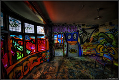
Paul and Sam Corliss's Street Art Photograph (2015:03:30 17:13:14)
Images, UC QuakeStudies
A photograph of street art on the side of a house. The artwork shows two tui watching over their eggs.
BeckerFraserPhotos April 2011 photograph 238
Images, UC QuakeStudies
A sign on the window of House of Travel, Victoria Street, reading, 'Moved to temporary premises... 100 Carmen Road, Hornby'.
BeckerFraserPhotos February 2012 photograph 0040
Images, UC QuakeStudies
A photograph of a house surrounded by liquefaction. The photograph is captioned by BeckerFraserPhotos, "24 Seabreeze Close, Bexley".
BeckerFraserPhotos February 2012 photograph 0035
Images, UC QuakeStudies
A photograph of a house surrounded by liquefaction. The photograph is captioned by BeckerFraserPhotos, "22 Seabreeze Close, Bexley".
BeckerFraserPhotos May 2011 photograph 0530
Images, UC QuakeStudies
Photograph captioned by BeckerFraserPhotos, "Rear of 214 Tuam Street (old opera house) viewed from Manchester Street. Telephoto image".
BeckerFraserPhotos February 2012 photograph 0071
Images, UC QuakeStudies
A photograph of the interior of a damaged house. The photograph is captioned by BeckerFraserPhotos, "Seabreeze Close, Bexley".
BeckerFraserPhotos December 2011 photograph 2215
Images, UC QuakeStudies
A photograph of a Christmas message written on the wall of a house at Cannon Hill Crescent in Mt Pleasant.
BeckerFraserPhotos February 2012 photograph 0062
Images, UC QuakeStudies
A photograph of the interior of a damaged house. The photograph is captioned by BeckerFraserPhotos, "Seabreeze Close, Bexley".
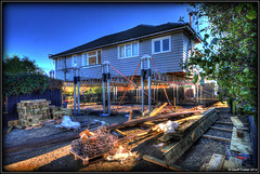
Photograph by Jocelyn Kinghorn 491
Images, UC QuakeStudies
The Grange Guest House with scaffolding in front of the windows. Rubbish skips can be seen on the property grounds.