Search
found 302 results
Images for [empty query]; more images...
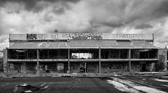


20160104_1602_7D2-20 Porritt Park
Images, eqnz.chch.2010
Porritt Park was, before the earthquakes, the headquarters of hockey in this region. Two astro-turf fields (the main one was to the left of the building), and corporate offices etc. The earthquakes buckled all the playing surfaces and damaged the buildings; a couple of smaller ones have been removed. Hockey shifted the other side of the cit...
20160415_0029_1D3-24 Red Zone Closures
Images, eqnz.chch.2010
The permanent closure (to motor vehicles) of the Bexley red zone streets has started. This was once the main south-north route just west of the Avon River in the New Brighton area, till an expressway (ring road) was built about 80m to the west (right) about 12-13 years ago. Then it became just another suburban street, but now all the houses ...
20160307_6607_7D2-110 Interior removal
Images, eqnz.chch.2010
The Forsyth Barr building has stood silent and empty (except the occasional intruder and pigeons) since the February 2011 earthquake. It was sold "as is" and I understand that it is now going to be fitted out as a hotel. This is the building that had severe stairwell damage during the quake necessitating people being lowered via ropes etc on t...
20160415_0039_1D3-40 The Wobbly Jetty - 1 (106/366) [Explored]
Images, eqnz.chch.2010
The South New Brighton jetty was rebuilt a couple of years before the 2010 and 2011 earthquakes wrecked it. Then, it was straight, level and all railings on left side were intact. Was closed to the public for about four years but is open now.
20160307_6619_7D2-125 Covering up
Images, eqnz.chch.2010
One of the most beautiful pieces of wall art (added to the blank walls after buildings were demolished following the earthquakes) in Christchurch, is now being hidden by a new building in front of it. www.flickr.com/photos/johnstewartnz/15499321681/in/...
20160307_0036_EOS M-41 Summit Road closed
Images, eqnz.chch.2010
None
20160415_0044_1D3-38 The Wobbly Jetty - 2
Images, eqnz.chch.2010
The South New Brighton jetty was rebuilt a couple of years before the earthquakes wrecked it. Was closed to the public for about four years but is open now.
20160307_0012_1D3-32 Subway is closed (067/366)
Images, eqnz.chch.2010
The Subway shop in the High Street Mall has not operated since lunch time on the 22nd February 2011 when the most damaging of Christchurch and Canterbury's earthquakes struck. I assume the building is still to be demolished.
20160307_6634_7D2-82 Really Wild!
Images, eqnz.chch.2010
A section of retaining wall that tilted in the Christchurch 2011 earthquake. At the Edmunds Band Rotunda sight. Still not repaired,
20160307_6626_7D2-200 Pigeon City
Images, eqnz.chch.2010
Pigeons sit on the remains of one of the tallest buildings in Christchurch that was 95% demolished two or three years ago. The basement (now filled with water) and the columns remain. Demolished due to damage from the Christchurch 2011 earthquake.
20160419_7732_7D2-400 The City is in Rebuild phase (110/366)
Images, eqnz.chch.2010
20160419_7732_7D2-400 The City is in Rebuild phase (110/366) A totally different view to a few years ago. Most of the tall buildings have gone and construction is underway on a lot of new buildings, View from across the Estuary in Redcliffs. A couple of days ago the government agency controlling the post-earthquake work (CERA - Canterbury Ea...
20160703_144759_GT-S7275T-04 New sea wall at Redcliffs (185/366)
Images, eqnz.chch.2010
20160703_144759_GT-S7275T-04 New sea wall at Redcliffs (185/366) I went for a drive in my second car mainly to charge the battery up and forgot to take my camera gear so only had my phone. This is the new rock wall to replace the severely damaged previous one (in the February 2011 earthquake). Work is still underway on the car parking and p...
20160612_8429_1D3-40 Abandoned and maybe forgotten
Images, eqnz.chch.2010
AMI Stadium (Lancaster Park), not used since the February 2011 earthquake. It was used predominantly for rugby and cricket. We are still waiting to see what the outcome is for this stadium. Government want a new one closer to the CBD, so there is talk of this being demolished, while others want it repaired. The concrete pad lower left is ...
20160613_0044_7D2-100 Jetty Closed
Images, eqnz.chch.2010
The South New Brighton jetty has been closed for 3 or 4 years (fenced off) then the fence was removed and it was "open", but nothing has happened to it since the earthquakes, but it is closed again now, although it looks like a home made sign!
20160612_8434_1D3-40 Ticket Sales (164/366)
Images, eqnz.chch.2010
The ticket office at Lancaster Park (AMI Stadium), not used since the February 2011 earthquake. Windows broken and door boarded up. We are still waiting to see what the outcome is for this stadium. Government want a new one closer to the CBD, so there is talk of this being demolished, while others want it repaired.
20161018_9063_7D2-70 Restricted Area (292/366)
Images, eqnz.chch.2010
In the suburban red zone on Avonside Drive.
20161112_9965_7D2-24 Another view of part of the Cultivate Christchurch in…
Images, eqnz.chch.2010
None
The future face of Christchurch?
Images, eqnz.chch.2010
20161112_9961_7D2-70 The future face of Christchurch? Cultivate Christchurch is operating this urban farm in the city, about 5-10 minutes walk to Cathedral Square. Many of the buildings in this area were demolished after the earhquakes, and in the background is a new building on Kilmore Street.
20161211_0216_1D3-24 Six years on
Images, eqnz.chch.2010
A view that was impossible six years ago. There was a group of buildings including another high-rise in the vacant area in the middle ground.
Bottom-up governance after a natural disaster: a temporary post-earthquake…
Research Papers, Lincoln University
Creative temporary or transitional use of vacant urban open spaces is seldom foreseen in traditional urban planning and has historically been linked to economic or political disturbances. Christchurch, like most cities, has had a relatively small stock of vacant spaces throughout much of its history. This changed dramatically after an earthquake and several damaging aftershocks hit the city in 2010 and 2011; temporary uses emerged on post-earthquake sites that ran parallel to the “official” rebuild discourse and programmes of action. The paper examines a post-earthquake transitional community-initiated open space (CIOS) in central Christchurch. CIOS have been established by local community groups as bottom-up initiatives relying on financial sponsorship, agreements with local landowners who leave their land for temporary projects until they are ready to redevelop, and volunteers who build and maintain the spaces. The paper discusses bottom-up governance approaches in depth in a single temporary post-earthquake community garden project using the concepts of community resilience and social capital. The study analyses and highlights the evolution and actions of the facilitating community organisation (Greening the Rubble) and the impact of this on the project. It discusses key actors’ motivations and values, perceived benefits and challenges, and their current involvement with the garden. The paper concludes with observations and recommendations about the initiation of such projects and the challenges for those wishing to study ephemeral social recovery phenomena.
The Harcourts Building : A 'seismic' shift?
Research Papers, Lincoln University
Purpose - The purpose of this paper is to identify through the application of Actor Network Theory (ANT) the issues and impediments to the implementation of mandatory seismic retrofitting policies proposed by the New Zealand Government. In particular the tension between the heritage protection objectives contained in the Resource Management Act 1991 and the earthquake mitigation measures contained in the Building Act 2004 are examined. Design/methodology/approach - The paper uses a case study approach based on the Harcourts Building in Wellington New Zealand and the case law relating to attempts to demolish this particular building. Use is made of ANT as a 'lens' to identify and study the controversies around mandatory seismic retrofitting of heritage buildings. The concept of translation is used to draw network diagrams.
Post-disaster indigenous mental health support: Tangata whaiora networks a…
Research Papers, Lincoln University
This paper identifies and analyses the networks of support for tangata whaiora (mental health clients) utilising a kaupapa Mäori health service following the Ötautahi/Christchurch earthquakes in Aotearoa New Zealand from 2010 to 2012. Semi- structured interviews were undertaken with 39 participants, comprising clients (Mäori and Päkehä), staff, managers and board members of a kaupapa Mäori provider in the city. Selected quotes are presented alongside a social network analysis of the support accessed by all participants. Results show the signifi cant isolation of both Mäori and Päkehä mental health clients post- disaster and the complexity of individuals and collectives dealing with temporally and spatially overlapping hazards and disasters at personal, whänau and community level.
Earthquake impacts on immigrant participation in the Greater Christchurch …
Research Papers, Lincoln University
The Canterbury earthquakes that happened in 2010 and 2011 have attracted many migrant workers to the region to assist with the rebuilding effort. However, research on the impact of influx of migrants on the labour market outcomes of a local industry post-disaster is limited internationally and locally. The main objective of this study is to examine the impact of the Canterbury earthquakes on the changes in demographic composition and occupational structure for the local and foreign workers in the Greater Christchurch construction industry. Replicating the discrete dependent variable regression methods used in the study by Sisk and Bankston III (2014), this study also aimed to compare their findings on the impact of the influx of migrants on the New Orleans construction industry with outcomes in Greater Christchurch. Customised data from New Zealand Censuses 2006 and 2013 were used to represent the pre- and post-earthquake periods. This study found that the rebuild has provided opportunities for migrant workers to enter the Greater Christchurch construction industry. The increased presence of migrant construction workers did not displace the locals. In fact, the likelihoods for both locals’ and migrants’ participation in the industry improved post-earthquakes. The earthquakes also increased overall workers’ participation at the lowest end of the occupational structure. However, the earthquakes created few significant changes to the distribution of local and migrant workers at the various occupational levels in the industry. Local workers still dominated all occupational levels post-earthquakes. The aggregated education levels of the construction workers were higher post-earthquakes, particularly among the migrant workers. Overall, migrant workers in the Greater Christchurch construction industry were more diverse, more educated and participated in higher occupational levels than migrants assisting in the New Orleans rebuild, due possibly to differences in immigration policies between New Zealand and the United States of America.
Liquefaction features produced by the 2010-2011 Canterbury earthquake sequ…
Research Papers, Lincoln University
Liquefaction features and the geologic environment in which they formed were carefully studied at two sites near Lincoln in southwest Christchurch. We undertook geomorphic mapping, excavated trenches, and obtained hand cores in areas with surficial evidence for liquefaction and areas where no surficial evidence for liquefaction was present at two sites (Hardwick and Marchand). The liquefaction features identified include (1) sand blows (singular and aligned along linear fissures), (2) blisters or injections of subhorizontal dikes into the topsoil, (3) dikes related to the blows and blisters, and (4) a collapse structure. The spatial distribution of these surface liquefaction features correlates strongly with the ridges of scroll bars in meander settings. In addition, we discovered paleoliquefaction features, including several dikes and a sand blow, in excavations at the sites of modern liquefaction. The paleoliquefaction event at the Hardwick site is dated at A.D. 908-1336, and the one at the Marchand site is dated at A.D. 1017-1840 (95% confidence intervals of probability density functions obtained by Bayesian analysis). If both events are the same, given proximity of the sites, the time of the event is A.D. 1019-1337. If they are not, the one at the Marchand site could have been much younger. Taking into account a preliminary liquefaction-triggering threshold of equivalent peak ground acceleration for an Mw 7.5 event (PGA7:5) of 0:07g, existing magnitude-bounded relations for paleoliquefaction, and the timing of the paleoearthquakes and the potential PGA7:5 estimated for regional faults, we propose that the Porters Pass fault, Alpine fault, or the subduction zone faults are the most likely sources that could have triggered liquefaction at the study sites. There are other nearby regional faults that may have been the source, but there is no paleoseismic data with which to make the temporal link.
Understanding residential infill: a Christchurch case study of typologies …
Research Papers, Lincoln University
Advocates for Compact City, Smart Growth and New Urbanism claim intensification of land use as a means to achieve sustainability imperatives, manage urbanisation and curb peripheral sprawl. It appears policy makers and planners have taken this perspective into consideration over the last two decades as intensification appears more prevalent in policy and planning. Literature points to residential infill as a method of providing for housing development within city limits. While residential infill is recognised in literature, little is known about what it consists of and the different stakeholders involved. This study will document different types of infill, identify various stakeholders associated with the different types and how their roles align and conflict.
Expanding the conversational terrain: Using a choice experiment to assess …
Research Papers, Lincoln University
The Canterbury region of New Zealand was shaken by major earthquakes on the 4th September 2010 and 22nd February 2011. The quakes caused 185 fatalities and extensive land, infrastructure and building damage, particularly in the Eastern suburbs of Christchurch city. Almost 450 ha of residential and public land was designated as a ‘Red Zone’ unsuitable for residential redevelopment because land damage was so significant, engineering solutions were uncertain, and repairs would be protracted. Subsequent demolition of all housing and infrastructure in the area has left a blank canvas of land stretching along the Avon River corridor from the CBD to the sea. Initially the Government’s official – but enormously controversial – position was that this land would be cleared and lie fallow until engineering solutions could be found that enabled residential redevelopment. This paper presents an application of a choice experiment (CE) that identified and assessed Christchurch residents’ preferences for different land use options of this Red Zone. Results demonstrated strong public support for the development of a recreational reserve comprising a unique natural environment with native fauna and flora, healthy wetlands and rivers, and recreational opportunities that align with this vision. By highlighting the value of a range of alternatives, the CE provided a platform for public participation and expanded the conversational terrain upon which redevelopment policy took place. We conclude the method has value for land use decision-making beyond the disaster recovery context.
Tram vs Bus in 1930s Crush
Articles, Lost Christchurch
The busiest intersection in the central city heaves under a rush of pedestrians, buses, trams, cyclists and private motor cars, pushing passed each other as they head for various parts of the city.
A Great Pilgrimage Over the Clouds
Articles, Lost Christchurch
Imagine an event so exciting, so spectacular, that 38 trains were required travelling at 28 minute intervals to convey curious sightseers to Lyttelton in order to witness it. The roads from Christc…
Was Christchurch the birthplace of Mary Poppins?
Articles, Lost Christchurch
Almost a century ago, the story of Mary Poppins and the Match-Man was published for the first time – in Christchurch’s afternoon newspaper, The Sun. But how did the story of the world’s most famous…
Diverse Density: An alternative housing strategy
Research papers, Victoria University of Wellington
Diverse Density proposes an alternative housing strategy to the idealistic top-down process of housing development. The term ‘Top – down’ refers to a situation in which decisions are made by a few people in authority rather than by the people who are affected by the decisions (Cambridge). Problems/Position/Question: New Zealand’s urban housing is in a period of flux. Pressures of densification have permitted the intervention of medium density housing development schemes but these are not always successful. These typically top-down processes often result in internally focused design schemes that do not adhere to their specific context. The subsequent design outcomes can cause detrimental impacts to the local, urban and architectural conditions. With vast quantities of council regulations, building restrictions and design guidelines clouding over the housing sector, commonly referred to as ‘red tape’, occupant participation in the housing development sector is dwindling. A boundless separation between top-down and traditional housing processes has occurred and our existing neighbourhoods and historic architectural character are taking on the brunt of the problem. The thought-provoking, alternative housings strategies of key research theorists Alejandro Aravena and John Habraken frame positions that challenge contemporary densification methods with an alternative strategy. This position is addressed by endeavoring to answer; How can demands for denser housing achieve dynamic design responses that adhere to changes in occupancy, function and local site conditions? Aim: The aim of this thesis is to challenge New Zealand’s current housing densification methods by proposing an alternative densification strategy. Explicit devotion will be attributed to opposing top-down building developments. Secondly, this thesis aims to test a speculative site-specific housing model. The implementation of a Christchurch housing scenario will situate an investigative study to test the strategy and its ability to stimulate greater diversity, site responsiveness, functional adaptability and occupancy permutation. The post-earthquake housing conditions of Christchurch provide an appropriate scenario to test and implement design-led investigations. Objectives: The primary objectives of this design-led research investigation it to challenge the idealistic top-down method of developing density with a new method to: - Develop contextual architectural cohesion - Encourage residential diversity - Reinvigorate architectural autonomy - Respond to, and recognise, existing site conditions - Develop a housing model that: - Adapts to occupant functionality preferences - Caters to occupancy diversity - Achieves contextual responsiveness The proposition is addressed through a speculative design-led scenario study. A well-established Christchurch urban environment is adopted to implement and critique the envisioned alternative strategy. Development of the designs responsiveness, adaptability, and functionality produce a prototype housing model that actively adheres to its particular context. Implication: The implications of this research would be an alternative densification strategy to perceive the advancement of punctual assessment of building compliance. With accelerated building processes, the research may have implications for addressing New Zealand’s housing crisis whilst simultaneously providing diverse, personable and responsive architectural solutions. A more dynamic, up-to-date and responsive housing development sector would be informed.