
Search
found 15 results
Images for roads; more images...


20121117_2387_G12-06 New Brighton Road flooded again
Images, eqnz.chch.2010
With the land dropping about 1metre to 1.4metres after the earthquakes, a few roads besides the Avon and Heathcote Rivers are flooded with very high tides. Extra stop banks (on right) erected after the quakes have helped, but the road is now well below high water level. New Brighton Road, just short of New Brighton. The Pages Road bridge may b...
20120131_8174_1D3-400 Eathquake damage
Images, eqnz.chch.2010
Houses above Main Road, Sumner.
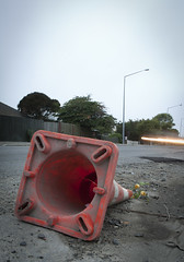
20120321_2416_1D3-24 Fallen Cone
Images, eqnz.chch.2010
A month after the 1st anniversary of the deadly Christchurch earthquake (22/02/11) a road cone lies on New Brighton Road, alongside the Avon River. Part of the earthquake 1st anniversary remembrance was for people to place flowers in road cones (and there are hundreds of thousands in the city). Many had flowers in them, as this one did. Photo ...
20120131_8153_1D3-400 Conatiner wall
Images, eqnz.chch.2010
Part of the container wall to stop rock falls on Main Road, Sumner.
20121117_0314_1D3-200 Summit Road - Closed
Images, eqnz.chch.2010
Obvious seeing why the Summit Road has been closed below Mt Cavendish since the February 22 2011 earthquake. There are some large rocks there!
20121117_0316_1D3-70 Summit Road Closed
Images, eqnz.chch.2010
Obvious seeing why the Summit Road has been closed below Mt Cavendish since the February 22 2011 earthquake. There are some large rocks there!
20121018_9144_1D3-60 Tunnel building
Images, eqnz.chch.2010
Built in the early 1960s for the Lyttelton Road Tunnel, it was severley damaged in the February 2011 earthquake and is not currently used.
20120128_8071_1D3-400 Redcliffs wall
Images, eqnz.chch.2010
The sea wall at Beachville Road, Redcliffs, after the earthquake. It used to be straight and level - not now! As a teenager I went fishing off this wall.
20120131_8167_1D3-400 Shag Pile
Images, eqnz.chch.2010
What more can one say except that Shag Rock is now about one third it's original height. Whitewash Head in the background with the road that now drops over a cliff.
Emergency Response
Images, eqnz.chch.2010
A few older Christchurch Earthquake Pics from after the 6.3 last Feb (2011). And yes the aftershocks are still happening.. Twitter | Facebook |
20120718_1497_G12-25 New Brighton icon is demolished
Images, eqnz.chch.2010
The old New Brighton Power Boat Club building was badly damaged in the February 2011 earthquake, and is only now (July 2012) being demolished. The building is just down the road from where I grew up and is a New Brighton iconic building.
20120718_1499_G12-9 New Brighton icon is demolished
Images, eqnz.chch.2010
The old New Brighton Power Boat Club building was badly damaged in the February 2011 earthquake, and is only now (July 2012) being demolished. The building is just down the road from where I grew up and is a New Brighton iconic building.
Beachcomber Dairy
Images, eqnz.chch.2010
20120321_2397_1D3-47 Beachcomber Dairy Corner of New Brighton Road and Rawson Street, New Brighton. This diary is inside the suburban red zone and will probably be demolished some time in the future. See how the earthquakes have moved the footpath - the post and phone box used to stand straight! This is one of the Teleccom Wi-Fi hotspot boo...
20120702_1387_G12-18 Another one bites the dust
Images, eqnz.chch.2010
8 Velsheda Street, Bexley, Christchurch, across the road from my house was demolished a week or so ago, just one of many demolitions of Red Zone properties at the moment. This house was about ten years old and suffered land damage during the 4th September 2010 and 22nd February 2011 earthquakes. The same fate awaits my house later in the year o...
20120131_8169_1D3-400 Conatiner wall
Images, eqnz.chch.2010
Part of a house that fell can be seen on the rocks above right hand containers.
- 1