Search
Images for F+; more images...
20130424_6256_1D3-400 South New Brighton Jetty - 1
Images, eqnz.chch.2010
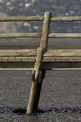
The jetty in the South New Brighton Domain was rebuilt a few years ago. It was straight and level till the earthquakes. Has been closed for 2½ years now.
20130424_6254_1D3-400 South New Brighton Jetty - 2
Images, eqnz.chch.2010
The jetty in the South New Brighton Domain was rebuilt a few years ago. It was straight and level till the earthquakes. Has been closed for 2½ years now.
20130424_6246_1D3-400 South New Brighton Jetty - 3
Images, eqnz.chch.2010
The jetty in the South New Brighton Domain was rebuilt a few years ago. It was straight and level till the earthquakes. Has been closed for 2½ years now. The shags like it though!
20130125_1749_1D3-400 Road Closed 1
Images, eqnz.chch.2010
20130125_1749_1D3-400 Road Closed 1 The Lyttelton side of Evans Pass is closed (since the earthquake 23 months ago - 22/02/11). Prior to the road tunnel (through the Port Hills) opening in the early 1960s this was the main access road to the port of Lyttelton. #3072
MtPleasantApril2013EDgold
Images, eqnz.chch.2010
Christchurch CBD earthquake rebuild lit in the last fading golden glow of the day - taken with 70-200 F4 IS from Mt Pleasant. I count at least three big cranes!
The story of Christchurch (Day 229/365)
Images, eqnz.chch.2010
20130817_2457_1D3-400 The story of Christchurch (Day 229/365) Many roads are closed all over eastern Christchurch as infra-structure repairs are carried out, whether it be water supplies, sewer repairs (as is the case here) or general road repairs, In just over two weeks it will be three years since the first earthquake happened (4th September...
South New Brighton bridge damage (under repair)
Images, eqnz.chch.2010
20130211_2645_1D3-840 South New Brighton bridge damage (under repair) Earthquake damage (that right hand abutment should be vertical with the bridge and the hand rail level). Bridge is closed to eastbound traffic (to left) and has a 3500kg weight limit as well. The eastern approach is the same. Damage caused mainly in the 04/09/10 and 22/02/11...
Lupins in the Red Zone
Images, eqnz.chch.2010
20131110_8308_EOS M-28 Lupins in the Red Zone Another empty Red Zone section. Avonside Drive, Dallington. #4393
20131110_8306_EOS M-55 Beauty in the Red Zone
Images, eqnz.chch.2010
There is some beauty in the desolate and near empty Dallington Red Zone.
20130206_0211_EOS M-55 Town Hall and Ferrier Fountain
Images, eqnz.chch.2010
None
20130315_0989_EOS M-46 Closed for refurbishment? Building demolished (Day …
Images, eqnz.chch.2010
Strange sign when the building it refers to is no longer there. Earthquake damage.
Another one on the way out!
Images, eqnz.chch.2010
20130704_7680_EOS M-22 Another one on the way out! The Mack tractor unit with "half a house" ready to depart in the middle of the night, when the roads are quiet. But where is this house heading too? #3900
20130827_2656_1D3-24 Cashel Street looking east
Images, eqnz.chch.2010
None
20130827_2595_1D3-24 Bridge repairs
Images, eqnz.chch.2010
None
20130206_0215_EOS M-47 Ferrier Fountain at the Town Hall
Images, eqnz.chch.2010
Full of weeds after nearly two years of neglect. First time I have been in Victoria Square in over two years.
20130416_1284_EOS M-33 200 metres
Images, eqnz.chch.2010
A bit of the now demolished QEII (Queen Elizabeth II) Park running track in the "Gap Filler" on the old Deka site in New Brighton (last occupied by a charity barn before a major fire and subsequent demolition).
20130206_0195_EOS M-21 Salvation Army Citadel
Images, eqnz.chch.2010
A week ago this building was intact, now partially demolished. Will be an empty site in a week or two.
20130827_2673_1D3-24 Clarendon Tower site
Images, eqnz.chch.2010
None
20130827_2590_1D3-32 Brewery Smokestack
Images, eqnz.chch.2010
None
20130827_2589_1D3-24 Demoliation of Canterbury Brewery
Images, eqnz.chch.2010
None
20130827_2685_1D3-45 Arts Centre repairs
Images, eqnz.chch.2010
None
20130827_2637_1D3-105 Looking up Victoria Street
Images, eqnz.chch.2010
None
20130610_7555_EOS M-22 19 Velsheda Street
Images, eqnz.chch.2010
Being prepared for removal. Is in red zone so has to go.d The house had minimal damage, but the land it was on was deemed to be no good - red zoned.
20130827_2677_1D3-95 Thanks 4 the Memories photo exhibit.
Images, eqnz.chch.2010
None
20130206_0177_EOS M-18 The remains of the old railway station - Moorhouse …
Images, eqnz.chch.2010
None
20130827_2653_1D3-24 12 level BNZ building now looks like this
Images, eqnz.chch.2010
None
20130915_3524_1D3-55 The Chalice and the remains
Images, eqnz.chch.2010
None
20130827_2661_1D3-24 Cashel Mall/Cashel Street
Images, eqnz.chch.2010
None
20131231_8485_EOS M-22 Quake City exhibit
Images, eqnz.chch.2010
Another city walk around, this time with my brother-in-law from Auckland. Also went to the Quake City exhibition in the city organised by the Canterbury Museum. First fine day for a while.
20130827_2668_1D3-88 Bridge of Remembrance
Images, eqnz.chch.2010
Cashel Mall/Cashel Street


