
Search
found 302 results
Images for 1D3; more images...


20130618_7675_1D3-200 No Entry
Images, eqnz.chch.2010
None
20130524_7223_1D3-80 Waste water
Images, eqnz.chch.2010
None
20121117_0314_1D3-200 Summit Road - Closed
Images, eqnz.chch.2010
Obvious seeing why the Summit Road has been closed below Mt Cavendish since the February 22 2011 earthquake. There are some large rocks there!
20121117_0342_1D3-85 Fuze Cafe
Images, eqnz.chch.2010
Went into this cafe a few times in years gone by (all on camera club field trips or photowalks). It was a nice two-storey building then. Not now after the earthquakes of 2010 and 2011.
20130618_7676_1D3-105 Brick Substation
Images, eqnz.chch.2010
None
20130618_7684_1D3-200 Sumner Road Closed
Images, eqnz.chch.2010
None
20130130_2018_1D3-170 How long will this view remain - brewery being demol…
Images, eqnz.chch.2010
None
20121117_0338_1D3-150 The old Police Station
Images, eqnz.chch.2010
Cordoned off after damage from the earthquakes.
20121117_0316_1D3-70 Summit Road Closed
Images, eqnz.chch.2010
Obvious seeing why the Summit Road has been closed below Mt Cavendish since the February 22 2011 earthquake. There are some large rocks there!
Bridge Street bridge, Christchurch earthquake
Images, eqnz.chch.2010
20100904_3322_1D3-200 Bridge Street bridge, Christchurch earthquake South Brighton Bridge. See the gap between the abutment and the bridge itself (just to right of lower person). #377
Road crack - Christchurch earthquake
Images, eqnz.chch.2010
20100904_3308_1D3-24 Road crack - Christchurch earthquake Outside our house after the 7.1 Richter Canterbury earthquake on September 4 2010 #369
Christchurch earthquake
Images, eqnz.chch.2010
20100904_3310_1D3-24 Christchurch earthquake Birch Street flooded from burst water main #371
Anzac Drive, Christchurch earthquake
Images, eqnz.chch.2010
20100904_3313_1D3-24 Anzac Drive, Christchurch earthquake Kenta with crack in ANZAC Drive #372
Bexley Garage, Christchurch earthquake
Images, eqnz.chch.2010
201090904_3316_1D3-28 Bexley Garage, Christchurch earthquake Bexley petrol station #373
20140112_7511_1D3-195 External Stairway
Images, eqnz.chch.2010
External stairs on the Forsyth Barr building in Christchurch. Portions of the internal stairwell collapsed during the earthquake of February 22nd 2011, necessitating use of various means of getting people out of the building. Was the fourth highest building in the city pre earthquakes, but it's future is uncertain. Was for sale "as is, where ...
20130524_7221_1D3-58 Pipes
Images, eqnz.chch.2010
See next photo
20130524_7228_1D3-24 Bexley shops 3
Images, eqnz.chch.2010
None
20130524_7225_1D3-24 Bexley shops 1
Images, eqnz.chch.2010
None
20130524_7207_1D3-75 Earthquake damage to a Hulverstone Drive house
Images, eqnz.chch.2010
Awaiting demolition
20130524_7208_1D3-50 Earthquake damage to a Hulverstone Drive "red zone" h…
Images, eqnz.chch.2010
Awaiting demolition. Blue pipes are water supply to anyone still living on Hulverstone Drive.
20130524_7214_1D3-40 Hidden park bench
Images, eqnz.chch.2010
Prior to the earthquakes (mainly the February 22 2011 event) this park bench was at track level. Shortly after the February quake someone in the council did the sums and realised that the area near the Avon River had dropped between a metre and 1.4m (about 4 foot), so a rush job by contractors shifted in many tonnes of rock and gravel to raise a...
20130524_7227_1D3-24 Bexley shops 2
Images, eqnz.chch.2010
None
20130524_7206_1D3-75 Vandalism to a vacant and yet to be demolished house.…
Images, eqnz.chch.2010
None
Six months on
Images, eqnz.chch.2010
20110821_1708_1D3-280 Six months on A house in Bexley damaged in the February earthquake still looks like this six months later.
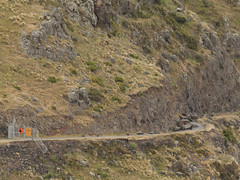
20130125_1760_1D3-115 Road Closed 2
Images, eqnz.chch.2010
This is the Summit Road below Mt Cavendish and shows a few remaining high buildings in the central city beyond (in setting sun). Just above centre is the doomed AMI Stadium (1) aka Lancaster Park, home to Canterbury cricket and rugby till the erathquakes.
South New Brighton bridge mevement - Christchurch earthquake
Images, eqnz.chch.2010
20100905_3349_1D3-24 South New Brighton bridge mevement - Christchurch earthquake The South Brighton bridge abutment (city side). Bridge looks fine, just both approaches have moved A LOT! #380
Bridge Street split depth - Christchurch earthquake
Images, eqnz.chch.2010
20100905_3347_1D3-32 Bridge Street split depth - Christchurch earthquake The city side of the South Brighton bridge. Approaches on both sides will need extensive work before this bridge can re-open. Bridge opened for traffic less than a week later, but still (23/09) has 30kmh speed restriction. #378
Community Energy Action - Christchurch earthquake
Images, eqnz.chch.2010
20100904_3327_1D3-65 Community Energy Action - Christchurch earthquake Community Energy Action Trust on Moorhouse Ave. #376
Broken footpath - Christchurch earthquake
Images, eqnz.chch.2010
20100904_3315_1D3-24 Broken footpath - Christchurch earthquake The footpath besides ANZAC Drive and the Bexley Wetlands. Liquefaction silt from well underground has flowed to the surface. Photo taken less than three hours after the 4:35am earthquake. #374
Bridge Street cracking - Christchurch earthquake
Images, eqnz.chch.2010
20100905_3346_1D3-24 Bridge Street cracking - Christchurch earthquake The city side of the South Brighton bridge. Approaches on both sides will need extensive work before this bridge can re-open. #379