Search
found 1843 results
Images for [empty query]; more images...


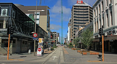
Cashel St Mall
Images, eqnz.chch.2010
December 2011
20140112_7509_1D3-70 Remains (My City in Ruins) (SH 8)
Images, eqnz.chch.2010
Scavenger Hunt 101 - SH 8 (abandoned building or ruin) The ruins/remains of what was the third highest building in Christchurch, pre earthquakes, the Price Waterhouse Coopers building in Armagh Street. At 76.3 metres ( 21 floors) the demolition has left the basement (now flooded) and these supports. Just one of many photos from Christchurch ...
20130901_2890_1D3-70 10:26am Gone!
Images, eqnz.chch.2010
See previous photo (exactly 3 hours earlier). Demolition of the support structure for NZ Breweries smokestack in Christchurch. CERES NZ's nibbler is at work, the pipe stack having been removed yesterday (Saturday). This is three hours after the previous photo, and just a pile of rubble sits beside the tree (largely undamaged despite being next...
Colombo and Armagh corner
Images, eqnz.chch.2010
20130827_2645_1D3-24 Colombo and Armagh corner What was one of the busier intersection pre earthquakes! #4150
Looking towards Cathedral Square
Images, eqnz.chch.2010
20130827_2621_1D3-47 Looking towards Cathedral Square Where once were buildings! From the corner of Armagh Street and Oxford Terrace. #4147
20130618_7675_1D3-200 No Entry
Images, eqnz.chch.2010
None
20130524_7204_1D3-105 Too many orange cones in Christchurch.
Images, eqnz.chch.2010
These have been thrown in the Avon River
20130524_7209_1D3-65 Table thrown away in Culver Place.
Images, eqnz.chch.2010
All red zoned and it looked like no one is living anywhere in Culver Place. All awaiting demolition.
MtPleasantApril2013EDgold
Images, eqnz.chch.2010
Christchurch CBD earthquake rebuild lit in the last fading golden glow of the day - taken with 70-200 F4 IS from Mt Pleasant. I count at least three big cranes!
20130524_7220_1D3-45 Pump house and pipes
Images, eqnz.chch.2010
None
20130312_0938_EOS M-39 T-Rex
Images, eqnz.chch.2010
Went for a drive down to South New Brighton/Southshore after work today to see what interesting birds I could find on the Estuary (godwits, skuas, terns etc), but passing Jellico Street, I saw this. T-Rex the seismic survey truck from the University of Texas that is visiting the city (first time out of USA). Weighs 30 tonne and from the marks o...
Cranmer Court
Images, eqnz.chch.2010
The Cranmer Court demolition started today in Christchurch. The 1876 building was originally a Normal School and was in a derelict state in the early 1980s when it was rescued and converted into apartments. The heritage-listed building was red-stickered after the February 2011 earthquake.
Christchurch City
Images, eqnz.chch.2010
Helicopter Flight over Christchurch New Zealand
The Cathedral of the Blessed Sacrament
Images, eqnz.chch.2010
Note the innovative use of hay bales on the left side of the image.
St. Albans Library
Images, eqnz.chch.2010
The community centre in my old neighbourhood. Now it's an empty lot.
GrandChancellorNov2011-1181
Images, eqnz.chch.2010
Closeup of the Grand Chancellor showing the south eastern corner, which is where it has slumped and broken and is now leaning in that direction. I note that they have taken some equipment out of the roof, you can see daylight through the gaps on the other side. The broken windows are also clearly visible with curtains hanging in some of them. ...
Window Painful
Images, eqnz.chch.2010
None
Powerless Christchurch CBD, NZ - Post February Earthquake
Images, eqnz.chch.2010
Much of the CBD will be cordoned off and without power (as you should be able to spot) for quite some time as a result of the damage caused by February's deadly earthquake.
20131231_8484_EOS M-22 Quake City exhibit
Images, eqnz.chch.2010
20131231_8484_EOS M-22 Quake City exhibit Another city walk around, this time with my brother-in-law from Auckland. Also went to the Quake City exhibition in the city organised by the Canterbury Museum. First fine day for a while. #4502
Christchurch, NZ - Damaged Facade
Images, eqnz.chch.2010
None
20131014_4128_1D3-40 Polluted Water (Day 287/365)
Images, eqnz.chch.2010
There are occasional sewerage spills into the Avon River while all the sewer and road repairs are carried out. This rock wall was level and well above high tide level prior to the eathquakes. All the houses that can been seen here (except for those on the distant Port Hills) are in the suburban "red zone" and are still to be demolished.
20131231_8509_EOS M-22 Forsyth Barr building with remains of PWC just behi…
Images, eqnz.chch.2010
20131231_8509_EOS M-22 Forsyth Barr building with remains of PWC just behind the green fence (across river) Another city walk around, this time with my brother-in-law from Auckland. Also went to the Quake City exhibition in the city organised by the Canterbury Museum. First fine day for a while. #4506
Where once stood houses (Day 348/365)
Images, eqnz.chch.2010
20131214_6268_1D3-24 Where once stood houses (Day 348/365) The area beside the lower Avon River in New Brighton of Evans Avenue and Admirals Way has been cleared of houses and boundary fences (there were between 15 and 20 houses on this block) , fully fenced with post and wire and "spray on" grass applied. These were all red zone properties a...
Waterhouse
Images, eqnz.chch.2010
The basement of the "Price Waterhouse" building after demolition after the Christchurch earthquakes...
20130921_3607_1D3-200 Last light on Castle Rock
Images, eqnz.chch.2010
A very different looking Castle Rock to what was there pre earthquakes.
20130902_2891_1D3-165 The view down the drive
Images, eqnz.chch.2010
Sewer repairs due to earthquake damage have our street totally closed off apart from pedestrian traffic down the footpath.
20130827_2656_1D3-24 Cashel Street looking east
Images, eqnz.chch.2010
None
20130901_2862_1D3-175 7:26am
Images, eqnz.chch.2010
Demolition of the support structure for NZ Breweries smokestack in Christchurch. CERES NZ's nibbler is at work, the pipe stack having been removed yesterday (Saturday). I retuned three hours later to see what progress had been made and it was GONE! See next photo. Damage to complex was from the 22/02/20011 earthquake.
20130827_2653_1D3-24 12 level BNZ building now looks like this
Images, eqnz.chch.2010
None
20130627_8868_1D3-32 Container support
Images, eqnz.chch.2010
Cathedral of the Blessed Sacrameny aka Christchurch Basilica