
Search
found 81 results
Images for new building; more images...


Digital Photograph: Posters in the Window of Leslie's Bookshop, London Str…
Images, Canterbury Museum
One landscape colour digital photograph taken on 19 November 2011 showing posters for the outdoor theatre production 'The Pirates of Corsair Bay' and the 2011 Lyttelton Summer Festival events scheduled for February and March 2011. The posters remained in the window of the red stickered building until it was demolished in early September 2012. A...
Digital Photograph: Elevated view of London Street, Lyttelton
Images, Canterbury Museum
One landscape colour digital photograph taken on 26 May 2013 of London Street, Lyttelton. The photograph was taken from St Davids Street looking west. The roofs of the portable buildings forming the temporary Lyttelton Police station are visible in the foreground. The Lyttelton Port Company offices and Tunnel Portal are prominent in the midgrou...
Digital Photograph: Demolition of former Library and Fire Station, corner …
Images, Canterbury Museum
One landscape colour digital photograph taken on 6 September 2011 showing the demolition of 2 Sumner Road, the former library and fire station. This building was a private residence at the time of its demolition. Photograph taken looking north on Oxford Street. Also visible in the photograph are the Lyttelton Information Centre, an entrance to ...
Digital Photograph: North side of London Street, Lyttelton
Images, Canterbury Museum
One landscape colour digital photograph taken on 19 November 2011 showing buildings on London Street. Visible in the photograph (left to right) are Bells Pharmacy - relocated into a converted house with law firm MacTodd on the upper floor, Portico (gift shop), Tommy Changs Cafe, and the edge of the Lyttelton Petanque Club Gap Filler initiative. ...
Digital Photograph: Census Poster in Window
Images, Canterbury Museum
One portrait colour digital photograph taken on 19 November 2011 showing a poster advertising the planned 2011 Census which was scheduled for Tuesday 8 March 2011. The census was abandoned because of the 22 February 2011 Earthquake. The poster was located in the window of the Lyttelton Information Centre on Oxford Street. The building was closed...
Badge: We [heart] you Weng
Images, Canterbury Museum
One circular metal and plastic badge featuring an image of a girl and the words 'We [heart] you Weng'. This personalised badge featuring an image of a girl and a personal message of love, was left at the site of the Canterbury Television (CTV) building after the 22 February 2011 earthquake. It was most likely left in commemoration of someone wh...
Digital Photograph: Lyttelton Fire Station, London Street, Lyttelton
Images, Canterbury Museum
One landscape colour digital photograph taken on 19 November 2011 showing the Lyttelton Fire Station. The building is fenced off and unused due to earthquake damage. To the right of the photograph the front of one of the Fire Appliances and the shipping containers set up in the rear car park to provide temporary facilities can be seen. Followin...
Digital Photograph: Corner of London and Oxford Streets, Lyttelton
Images, Canterbury Museum
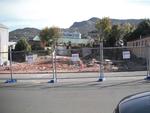
One landscape colour digital photograph taken on 19 November 2011 showing the site of the old Lyttelton Library, Council Chambers and Magistrates' Court on the corner of Oxford Street and Sumner Road. At the time of the 22 February 2011 Earthquake the building was in private ownership and was the premises of Moda Fotografica and a private resid...
Digital Photograph: Earthquake Damage to Lyttelton Historical Museum, Glad…
Images, Canterbury Museum
One landscape colour digital photograph taken on 25 September 2011 showing the site of the Lyttelton Historical Museum on the corner of Gladstone Quay and Donald Street. The photograph shows the temporary fencing around the levelled site. The building visible at the rear is the former Municipal Stables on Donald Street. To the right of the phot...
Digital Photograph: Former Convent of Our Lady of Mercy, Exeter Street, an…
Images, Canterbury Museum
One landscape colour digital photograph taken on 30 June 2011 showing earthquake damage to the former Convent of Our Lady of Mercy and to the Catholic Church of St Joseph the Worker. Photograph taken from St. Davids Street The sense of loss felt when confronted with the collapse or demolition of an historic building is compounded when that bui...
Digital Photograph: Exterior of Christchurch Chinese Methodist Church
Images, Canterbury Museum
One portrait colour digital photograph taken on 6 September 2010 showing earthquake damage to the red brick building of the Christchurch Chinese Methodist Church, 165 Papanui Road. The Christchurch Chinese Methodist Church on Papanui Road sustained severe damage during the 4 September 2010 earthquake. The church still stands although financial ...
Memorial Guitar: Kia Kaha
Images, Canterbury Museum
One white over-painted hand-made electric guitar made primarily from ash and maple timbers, also incorporating wood from a variety of historic buildings in Canterbury damaged or destroyed in the 2010 - 2011 earthquakes including the Arts Centre, Kutwell’s Warehouse, Lyttleton main street pub, Timeball Station, Carlton Hotel, Merivale shops, bui...
Digital Photograph: Demolition of the Royal Hotel, corner of Norwich Quay …
Images, Canterbury Museum
One landscape colour digital photograph taken on 27 April 2011 showing the demolition of the Royal Hotel on the corner of Norwich Quay and Canterbury Street. The hotel building shown in this photograph was the third on the site since 1851. It was built in 1916 as a replacement for the first Royal Hotel. The Royal Hotel was established in 1870 a...
Digital Photograph: Demolition of the former Library, Council Chambers and…
Images, Canterbury Museum
One landscape colour digital photograph taken on 11 June 2011 showing the demolition of the old Lyttelton Library, Council Chambers and Magistrates' Court on the corner of Oxford Street and Sumner Road. The photograph shows the upper floor of the building being demolished with a high reach digger. At the time of the 22 February 2011 Earthquake...
Digital Photograph: Partial demolition of the Old Lyttelton Harbour Board …
Images, Canterbury Museum
One landscape colour digital photograph taken on 19 May 2011 showing the partial demolition of the old Lyttelton Harbour Board Offices on the corner of Oxford Street and Norwich Quay. The photograph shows the upper floor of the original part of the building being removed and a temporary roof being constructed over the ground floor. At the time o...
Digital Photograph: Partial Demolition of the Old Lyttelton Harbour Board …
Images, Canterbury Museum
One landscape colour digital photograph taken on 16 June 2011 showing the partial demolition of the old Lyttelton Harbour Board Offices on the corner of Oxford Street and Norwich Quay. The photograph shows the temporary roof being constructed over the original ground floor of the building. At the time of the 22 February 2011 earthquake the build...
Digital Photograph: Earthquake damage to the Empire Hotel, London Street, …
Images, Canterbury Museum
One landscape colour digital photograph taken on 12 April 2011 showing earthquake damage to the Empire Hotel on London Street. The photograph shows the façade of the hotel supported by the framework installed to brace the building after the 4 September 2010 earthquake. Also visible on the fencing in the foreground is the advertising placard for...
Digital Photograph: Demolition of the Empire Hotel, London Street, Lyttelt…
Images, Canterbury Museum
One landscape colour digital photograph taken on 19 April 2011 showing the demolition of the Empire Hotel on London Street. The photograph shows the façade of the hotel supported by the framework installed to brace the building after the 4 September 2010 earthquake. A crane is being used to enable the east wall to be demolished by hand to avoid...
Digital Photograph: Godley Head
Images, Canterbury Museum
One landscape colour digital photograph taken on 26 May 2013 off Godley Head looking west towards the face of the cliffs. Rock which fell from the cliffs is heaped at the waters edge. Some of the buildings from the coastal defence battery are visible on top of the cliff. Volcanic banding is visible in the face of the cliffs. There were severa...
Digital Photograph: Exterior of Christchurch Chinese Methodist Church
Images, Canterbury Museum
One landscape colour digital photograph taken on 6 September 2010 showing earthquake damage to the red brick building of the Christchurch Chinese Methodist Church, 165 Papanui Road. The Christchurch Chinese Methodist Church on Papanui Road sustained severe damage during the 4 September 2010 earthquake. The red placards placed on the door of the...
Digital Photograph: Exterior of Christchurch Chinese Methodist Church
Images, Canterbury Museum
One landscape colour digital photograph taken on 6 September 2010 showing earthquake damage and a red placard on the red brick building of the Christchurch Chinese Methodist Church, 165 Papanui Road. The Christchurch Chinese Methodist Church on Papanui Road sustained severe damage during the 4 September 2010 earthquake. The red placards placed ...