Search
found 9 results

- 1
Digital Photograph: Earthquake Damage to Retaining Wall, corner of Oxford …
Images, Canterbury Museum
One landscape colour digital photograph taken on 15 June 2011 showing earthquake damage to the retaining wall on the northeast corner of Oxford and Exeter Streets. The wall was constructed from unreinforced blocks of local red volcanic rock held together with mortar. Retaining walls in Lyttelton were built of unreinforced soft volcanic stone in...
BeckerFraserPhotos March 2011 photograph 060
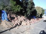
Images, UC QuakeStudies
A footpath on Sumner Road in Lyttelton. A low wall made from local volcanic stone has been demolished to the left.
Diamond Jubilee Clock Tower
Images, UC QuakeStudies
The damaged clock tower on Victoria Street, wrapped and braced to prevent further damage. The photographer comments, "Diamond Jubilee Clock Tower in Christchurch. Its legs wrapped up for protection. Volcanic stone and limestone clock tower with ornate wrought iron work with coloured glass around part of the tower and four clock faces. Clock Tower built in this location to commemorate the Diamond Jubilee of Queen Victoria. Has two white marble plaques and one bronze plaque set on stone work above arches".
Winter, Mark 1958- :Christchurch recovery package - cash cloud. 24 June 20…
Images, Alexander Turnbull Library
The cartoon shows Christchurch obscured by ash. Text reads 'Christchurch recovery package' and below are the words 'Cash cloud'. Context - Beginning on the 6th of June the Puyehue-Cordon Caulle volcano has been erupting for more than a week. Drifting ash clouds have been interupting flights. On Thursday 23 June Prime Minister John Key, Canterbury Earthquake Recovery Minister Gerry Brownlee and representatives from engineering consultants Tonkin & Taylor announced the first part of the Government's long-awaited land report that revealed the fate of up to 5000 quake-damaged homes. These homes were in the 'red zone'. But 10,500 owners in the orange zone were left in limbo, with their properties requiring further assessment. One of the options presented to residents in the red zone, ideal for people with replacement policies, was the government bought your land, and you dealt directly with your insurers about your house. However they got a shock when insurers told them they won't replace their homes, they'll only repair them, even though they're earmarked for certain demolition. Quantity: 1 digital cartoon(s).
BeckerFraserPhotos March 2011 photograph 061
Images, UC QuakeStudies
A footpath on Sumner Road in Lyttelton. A low wall made from local volcanic stone has been demolished to the right. The land beyond the footpath has been cordoned off. Below Lyttelton Harbour can be seen, with Mount Evans in the background.
BeckerFraserPhotos March 2011 photograph 006
Images, UC QuakeStudies
A retaining wall on Sumner Road in Lyttelton that is made from local volcanic stone. A section of the wall has collapsed during the 22 February 2011 earthquake, and the bricks cleared away since. A road cone has been placed by the slip to warn drivers.
Sunset over a damaged city
Images, eqnz.chch.2010
Overlooking McCormacks bay out across the city with the Southern Alps as a backdrop. There is still a strong effect from the July 11, 2011 Volcanic erruption (Puyehue) in Chile. Ash made it over to New Zealand causing very strong colours at sunset. The colours have not been artificially changed and its not a mash up. The parts of the city (and...
Nisbet, Alistair, 1958-: Daft things our forefathers did... 20 March 2011
Images, Alexander Turnbull Library
Text at top left reads 'Daft things our forefathers did The cartoon shows several nineteenth century gentlemen observing 'volcanic cones', a 'swamp' and 'faultlines underneath' and deciding to build a city. Context - Specifically the Christchurch earthquakes of 4 September 2010 and 22 February 2011 but generally the way many New Zealand cities are built on or near volcanoes, faultlines and swamps. Quantity: 1 digital cartoon(s).
Nisbet, Alistair, 1958-:[Mother Nature cooks up a menu of disasters] 14 Ja…
Images, Alexander Turnbull Library
A monster cook who represents 'Mother Nature' stirs several pots as storms swirl outside the window. She has a list of recipes that read 'earthquake entree, tornado twisties, blizzard Bolognese, volcanic mudcake, flood fondue, cyclone souffle'; she says 'Mmmm what shall I cook up next?' Context - the bad weather and the Christchurch earthquake that have afflicted the South Island recently. Published in The Sunday Star Times Quantity: 1 digital cartoon(s).