Search
found 31 results


- 1
- »
Photograph of Gap Filler Project 30 (4)
Images, UC QuakeStudies
A photograph of children and parents painting rocks for Rock on Eastside on the corner of Linwood Avenue and Aldwins Road. Rock on Eastside was an outdoor lounge and art space facilitated by Gap Filler and Youthtown. The paint was donated by Resene.
Photograph by Paul Corliss 3358
Images, UC QuakeStudies
A photograph of rock fall. The photograph is captioned by Paul Corliss, "Morgans Valley".
Photograph by Paul Corliss 3359
Images, UC QuakeStudies
A photograph of rock fall. The photograph is captioned by Paul Corliss, "Morgans Valley".
Photograph by Paul Corliss 3360
Images, UC QuakeStudies
A photograph of rock fall. The photograph is captioned by Paul Corliss, "Morgans Valley".
Photograph by Paul Corliss 3357
Images, UC QuakeStudies
A photograph of rock fall. The photograph is captioned by Paul Corliss, "Morgans Valley".
Photograph by Paul Corliss 3356
Images, UC QuakeStudies
A photograph of rock fall. The photograph is captioned by Paul Corliss, "Morgans Valley".
Photograph of Gap Filler Project 30 (2)
Images, UC QuakeStudies
A photograph of students from the University of Canterbury Student Volunteer Army at Rock on Eastside. Rock on Eastside was an outdoor lounge and art space facilitated by Gap Filler and Youthtown. The students helped other students from local high schools to build the site, which was on the corner of Aldwins Road and Linwood Avenue.
Photograph of Gap Filler Project 30 (7)
Images, UC QuakeStudies
A photograph of students enjoying Rock on Eastside, an outdoor lounge and art space on the corner of Aldwins Road and Linwood Avenue. The students have decorated the site by painting rocks they found throughout Christchurch and laying them out in patterns. There is also furniture made out of pallets in the background and 'Rock on Eastside' has been painted on the wall of a building.
Photograph of Gap Filler Project 30 (3)
Images, UC QuakeStudies
A photograph of students enjoying Rock on Eastside, an outdoor lounge and art space on the corner of Aldwins Road and Linwood Avenue. The students have decorated the site by painting rocks they found throughout Christchurch and laying them out in patterns.
Photograph of Gap Filler Project 30 (8)
Images, UC QuakeStudies
A photograph of a sofa made out of car tyres and a pallet at Rock on Eastside on the corner of Aldwins Road and Linwood Avenue. Rock on Eastside was a outdoor lounge and art space facilitated by Gap Filler and Youthtown. The sofa was made by students from the University of Canterbury Student Volunteer Army. Painted rocks have been placed in front of the sofa as decoration.
BeckerFraserPhotos May 2013 photograph 183
Images, UC QuakeStudies
A photograph captioned by BeckerFraserPhotos, "Castle Rock on the Port Hills, showing where a huge section tumbled down the hillside on 22 February 2011".
Photograph of Gap Filler Project 30 (5)
Images, UC QuakeStudies
A photograph of students participating in a Youthtown workshop at Eastgate Mall. The students are painting rocks for the Rock on Eastside outdoor lounge and art space which is facilitated by Gap Filler and Youthtown. The rocks will be used to create artworks on the site on the corner of Aldwins Road and Linwood Avenue.
Photograph of Gap Filler Project 30 (6)
Images, UC QuakeStudies
A photograph of students in Eastgate Mall with a trolley full of painted rocks. The students are participating in a workshop facilitated by Gap Filler and Youthtown where they painted these rocks. The rocks will be used to create Rock on Eastside, an outdoor lounge and art space on the corner of Aldwins Road and Linwood Avenue.
20130921_3607_1D3-200 Last light on Castle Rock
Images, eqnz.chch.2010
A very different looking Castle Rock to what was there pre earthquakes.
Photograph of Gap Filler Project 30 (1)
Images, UC QuakeStudies
A photograph of staff from Abseil Access in the car park outside their office on Quakers Quay in Woolston. The staff are standing next to a trailer full of rocks which they have gathered from the Port Hills. The rocks will be painted and used to define the boundaries of Rock on Eastside, an outdoor lounge and art space on the corner of Linwood Avenue and Aldwins Road.
Photograph by Paul Corliss 3428
Images, UC QuakeStudies
A photograph captioned by Paul Corliss, "Great Wall of Sumner".
Photograph by Paul Corliss 3429
Images, UC QuakeStudies
A photograph captioned by Paul Corliss, "Great Wall of Sumner".
Photograph by Paul Corliss 3427
Images, UC QuakeStudies
A photograph captioned by Paul Corliss, "Great Wall of Sumner".
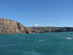
Digital Photograph: Godley Head, Lyttelton Harbour
Images, Canterbury Museum
One landscape colour digital photograph taken on 26 May 2013 off Godley Head looking north to Boulder Bay and Taylors Mistake. Rock which fell from the cliffs is heaped at the waters edge. Volcanic banding is visible in the face of the cliffs. There were several major rock falls along the coastal cliffs near Christchurch and Lyttelton Harbour....
20130130_1860_1D3-24 St Lukes in the City - stone memorial
Images, eqnz.chch.2010
185 pieces of Rock from Halswell Quarry to represent the 185 lives lost as a result of the 22/02/11 earthquake.
Digital Photograph: Godley Head Lighthouse
Images, Canterbury Museum
One landscape colour digital photograph taken on 26 May 2013 showing the Godley Head Lighthouse and cliffs. Taken from the entrance to Lyttelton Harbour looking north. The Godley Head Lighthouse (K4286) was discontinued on 6 July 2012. Volcanic banding is visible in the face of the cliffs. There were several major rock falls along the coastal ...
Digital Photograph: Earthquake damage to searchlight emplacements, Godley …
Images, Canterbury Museum
One landscape colour digital photograph taken on 26 May 2013 showing the southern cliffs of Godley Head. Taken from the middle of the shipping channel. Some earthquake damage to the cliffs is visible. There were several major rock falls along the coastal cliffs near Christchurch and Lyttelton Harbour. At Godley Head these caused damage to the W...
Digital Photograph: Godley Head
Images, Canterbury Museum
One landscape colour digital photograph taken on 26 May 2013 showing the southern cliffs of Godley Head, taken from the middle of the shipping channel. Some earthquake damage to the cliffs is visible. There were several major rock falls along the coastal cliffs near Christchurch and Lyttelton Harbour. At Godley Head these caused damage to the ...
Digital Photograph: Sumner Head
Images, Canterbury Museum
One landscape colour digital photograph taken on 26 May 2013 off Godley Head looking north towards Sumner Head. There were several major rock falls along the coastal cliffs near Christchurch and Lyttelton Harbour. In and around the suburb of Sumner some of these falls necessitated the abandonment of houses in areas where cliffs had given way or...
20130207_2231_1D3-165 Sumner and "container alley"
Images, eqnz.chch.2010
Nearly 80 40 foot containers (most two high) protect Wakefield Avenue in Sumner from further rock falls. Behind these (to the left) are houses, church, bowling club, RSA (Returned Servicemens Association) and other community buildings that have been isolated now for nearly two years now. On the right upper third boundary (just behind two stand a...
Digital Photograph: Godley Head
Images, Canterbury Museum
One landscape colour digital photograph taken on 26 May 2013 off Godley Head looking west towards the face of the cliffs. Rock which fell from the cliffs is heaped at the waters edge. Some of the buildings from the coastal defence battery are visible on top of the cliff. Volcanic banding is visible in the face of the cliffs. There were severa...
Digital Photograph: Retaining Wall, Sumner Road, Lyttelton
Images, Canterbury Museum
One landscape colour digital photograph taken on 27 May 2013 of a retaining wall in Sumner Road which was replaced due to earthquake damage. The original wall was created using red volcanic rock. Many walls like this were built using the Hard Labour Gang from the Lyttelton Gaol. The replacement wall has a small section of stone installed to sho...
20131014_4128_1D3-40 Polluted Water (Day 287/365)
Images, eqnz.chch.2010
There are occasional sewerage spills into the Avon River while all the sewer and road repairs are carried out. This rock wall was level and well above high tide level prior to the eathquakes. All the houses that can been seen here (except for those on the distant Port Hills) are in the suburban "red zone" and are still to be demolished.