
A photograph captioned by Paul Corliss, "Richard Fletcher at Pleasant Point Yacht Club".

A photograph captioned by Paul Corliss, "Richard Fletcher at Pleasant Point Yacht Club".

A photograph captioned by Paul Corliss, "Pleasant Point Yacht Club post-earthquake damage".

A photograph captioned by Paul Corliss, "Pleasant Point Yacht Club post-earthquake damage".

A photograph captioned by Paul Corliss, "Pleasant Point Yacht Club post-earthquake damage".

A photograph captioned by Paul Corliss, "Pleasant Point Yacht Club post-earthquake damage".

A photograph captioned by Paul Corliss, "Pleasant Point Yacht Club post-earthquake damage".

A photograph captioned by Paul Corliss, "Pleasant Point Yacht Club post-earthquake damage".

A photograph captioned by Paul Corliss, "Pleasant Point Yacht Club post-earthquake damage".

A photograph captioned by Paul Corliss, "Pleasant Point Yacht Club post-earthquake damage".

A photograph captioned by Paul Corliss, "Pleasant Point Yacht Club post-earthquake damage".

A photograph captioned by Paul Corliss, "Pleasant Point Yacht Club post-earthquake damage".

A photograph captioned by Paul Corliss, "Pleasant Point Yacht Club post-earthquake damage".

A photograph captioned by Paul Corliss, "Avon River at Kibblewhite Reserve".

A photograph captioned by Paul Corliss, "Avon River at Kibblewhite Reserve".

A photograph captioned by Paul Corliss, "Avon River at Kibblewhite Reserve".

A photograph captioned by Paul Corliss, "Avonside and Retreat Roads post earthquake".

A photograph captioned by Paul Corliss, "Avon River at Kibblewhite Reserve".

A photograph captioned by Paul Corliss, "Avonside and Retreat Roads post earthquake".

A photograph captioned by Paul Corliss, "Avonside and Retreat Roads post earthquake".

A photograph of a road over the Greendale fault line which has shifted laterally.

A photograph of a road over the Greendale fault line which has shifted laterally.

A photograph of lateral shifting in a rural road indicating the location of the Greendale fault line.

A photograph of volunteers from the Wellington Emergency Management Office, examining the lateral shifting of a rural road.

A photograph of lateral shifting in a rural road indicating the location of the Greendale fault line.

A photograph of a damaged footpath captioned by Paul Corliss, "Avonside and Retreat Roads post earthquake".

Rolleston, South Island, NZ

A very large woman stands wedged between two rows of concrete pillars eating a huge cream bun. She says 'Christmas fare protection... it helps prevent lateral spread!' Context - overeating at Christmas and lateral spreading, which is associated with liquefaction and tends to occur near streams and waterways as the soil mass moves towards them. Reference to the Christchurch earthquake of 4th September 2010.
Quantity: 1 digital cartoon(s).

Typical lateral damage to houses caused by the 7.1 magnitude quake in Christchurch at 4.35am on the 4th September 2010.
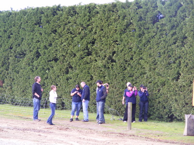
A photograph of volunteers from the Wellington Emergency Management Office taking photographs of the lateral shifting and cracks in a road after the 4 September 2010 earthquake.