
A photograph of University of Canterbury Geology students surveying land on the Greendale fault line.

A photograph of University of Canterbury Geology staff and students using ground penetrating radar (GPR) to survey land on the Greendale fault line.

A photograph of University of Canterbury Geology student Matt Cockcroft using ground penetrating radar (GPR) to survey land on the Greendale fault line.

A photograph of University of Canterbury Geology staff and students using ground penetrating radar (GPR) to survey land on the Greendale fault line.
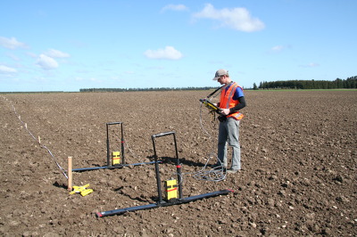
A photograph of University of Canterbury Geology student Matt Cockcroft using ground penetrating radar (GPR) to survey land on the Greendale fault line.

A photograph of damage to the ground of a paddock on the Greendale fault line.

A photograph of a crack in a paddock on the Greendale fault line.

A photograph of University of Canterbury Geology staff and students using ground penetrating radar (GPR) to survey land on the Greendale fault line. From left: Thomas Wilson, Zach Whitman and Matt Cockcroft.

A photograph of soil uplift in a paddock on the Greendale fault line.

A photograph of a paddock on the Greendale fault line.

A photograph of University of Canterbury Geology students using ground penetrating radar equipment to survey land on the Greendale fault line. From left: Matt Cockcroft, Zach Whitman and Dewiyani Bealing.

A photograph of a paddock on the Greendale fault line.

A photograph of a crack in a paddock on the Greendale fault line.

A photograph of damage to the ground of a paddock on the Greendale fault line.

A photograph of University of Canterbury Geology students Zach Whitman and Dewiyani Bealing using ground penetrating radar equipment to survey land on the Greendale fault line.

A photograph of University of Canterbury Geology students using ground penetrating radar equipment to survey land on the Greendale fault line. From left: Matt Cockcroft, Zach Whitman and Dewiyani Bealing.
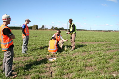
A photograph of University of Canterbury Geology staff and students using a dynamic cone penetrometer to measure soil strength of a paddock on the Greendale fault line.

A photograph of University of Canterbury Geology staff and students using ground penetrating radar (GPR) to survey land on the Greendale faultline. From left: Thomas Wilson, Dewiyani Bealing, Zach Whitman and Matt Cockcroft.

A photograph of damage to the ground of a paddock on the Greendale fault line.

A photograph of soil uplift in a paddock on the Greendale fault line.

A photograph of University of Canterbury Geology students using ground penetrating radar equipment to survey land on the Greendale fault line. From left: Matt Cockcroft, Zach Whitman and Dewiyani Bealing.

A photograph of damage to the ground of a paddock on the Greendale fault line.

A photograph of damaged land near River Road in Lincoln.

A photograph of damaged land near River Road in Lincoln.

A photograph of damaged land near River Road in Lincoln.

A photograph of damaged land near River Road in Lincoln.

You can see the movement of the curb and drop of land

A large crack where the land has slumped away next to a road.

Cracks in a footpath in Kaiapoi, where the land has slumped towards the river.

People examine large cracks running alongside Bridge Street where the land has slumped towards the river.