
Search
found 13 results


- 1
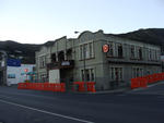
Digital Photograph: Lyttelton Coffee Company, London Street, Lyttelton
Images, Canterbury Museum
One portrait colour digital photograph taken on 19 November 2011 showing the framework of the Lyttelton Coffee Company Building surrounded by safety fencing. On the fencing are election hoardings and an advertisement for Samo, the café established by employees of the Lyttelton Coffee Company. Prior earthquake strengthening enabled the Lyttelton...
Digital Photograph: Earthquake Damage to Lyttelton Historical Museum on Gl…
Images, Canterbury Museum
One landscape colour digital photograph taken on 25 February 2011 showing damage to the Lyttelton Historical Museum on the corner of Gladstone Quay and Donald Street. The photograph shows bracing and safety fencing installed after the September 2010 earthquakes. Architect Closed after the September 2010 earthquakes, the Lyttelton Museum buildin...
Digital Photograph: Earthquake Damage to Lyttelton Historical Museum on Gl…
Images, Canterbury Museum
One landscape colour digital photograph taken on 14 July 2011 showing damage to the Lyttelton Historical Museum on the corner of Gladstone Quay and Donald Street. The photograph shows the safety fencing and containers installed after the 22 February 2011 earthquakes. Architect Closed after the September 2010 earthquakes, the Lyttelton Museum bu...
Digital Photograph: Mitre Hotel
Images, Canterbury Museum
One landscape colour digital photograph taken on 26 May 2013 on the corner of Norwich Quay and Canterbury Street, Lyttelton. The photograph shows the Mitre Hotel surrounded by temporary fencing. Three years after the 2010-2011 earthquakes there are still many uncertainties about which buildings can or will be retained. These buildings, or parts...
Digital Photograph: View looking northwest from the Gaol Steps, Lyttelton
Images, Canterbury Museum
One landscape colour digital photograph taken on 13 May 2011 looking northwest from the Gaol Steps. In the foreground is the edge of the Lyttelton Rose Garden, the safety fencing around the Upham Clock is visible. Below this is the intersection of Winchester and Oxford Streets. Prominent in the mid ground are the Catholic Church of St Joseph the...
Digital Photograph: Site of the Volcano Restaurant, corner of London and C…
Images, Canterbury Museum
One landscape colour digital photograph taken on 8 June 2011 showing the site of the Volcano Restaurant on the corner of London and Canterbury Streets. The site is fenced with temporary fencing. The concrete of the floor of the building is visible. On the fence are two artworks, both made from woollen blankets. One, made from a cream blanket is ...
Digital Photograph: Gaol Steps and Lyttelton Main School, Oxford Street, L…
Images, Canterbury Museum
One landscape colour digital photograph taken on 13 May 2011 showing the damage to the Gaol Steps between Oxford and St Davids Streets and the upper playground of Lyttelton Main School. The Gaol Steps are a pedestrian link between Oxford and St Davids Streets. In October 2013 these steps were closed and barricaded with temporary fencing because...
Digital Photograph: Earthquake damage to St Joseph's Church, Winchester St…
Images, Canterbury Museum
One portrait colour digital photograph taken on 19 April 2011 showing earthquake damage to the Catholic Church of St Joseph the Worker in Winchester Street Lyttelton. Photograph shows the southern end of church. The fencing erected around the Catholic Church of St Joseph the Worker shows the emphasis which was placed on public safety in the mon...
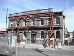
Digital Photograph: Earthquake Damage to Canterbury Hotel and shops. Oxfor…
Images, Canterbury Museum
One landscape colour digital photograph taken on 15 June 2011 showing earthquake damage to the former Canterbury Hotel and adjoining row of shops on Oxford Street. This photograph was taken on Oxford Street and shows the collapsed façade of the row of shops behind safety fencing, the interior of the building is exposed. Shadbolt House is visib...
Digital Photograph: Earthquake Damage to Canterbury Hotel and shops. Oxfor…
Images, Canterbury Museum
One landscape colour digital photograph taken on 15 June 2011 showing earthquake damage to the former Canterbury Hotel and adjoining row of shops on Oxford Street. This photograph was taken on Oxford Street and shows the collapsed façade of the row of shops behind safety fencing, the interior of the building is exposed. The design of many older...
Digital Photograph: Earthquake damage to the Empire Hotel, London Street, …
Images, Canterbury Museum
One landscape colour digital photograph taken on 12 April 2011 showing earthquake damage to the Empire Hotel on London Street. The photograph shows the façade of the hotel supported by the framework installed to brace the building after the 4 September 2010 earthquake. Also visible on the fencing in the foreground is the advertising placard for...
Digital Photograph: Earthquake Damage to Lyttelton Historical Museum, Glad…
Images, Canterbury Museum
One landscape colour digital photograph taken on 25 September 2011 showing the site of the Lyttelton Historical Museum on the corner of Gladstone Quay and Donald Street. The photograph shows the temporary fencing around the levelled site. The building visible at the rear is the former Municipal Stables on Donald Street. To the right of the phot...
Photographs of central Christchurch after the 2010 and 2011 earthquakes
Images, Alexander Turnbull Library
Photographs of central Christchurch after the 2010-2012 earthquakes taken 25 February 2012 by Sean McMahon. Locations are chiefly Manchester, Saint Asaph, Cashel, Columbo and Lichfield Streets, and the Bridge of Remembrance. Images show fencing around areas closed to the public, damaged and collapsed commercial buildings, cleared sites, re-opened Cashel Street area with shops and a cafe. Source of title - Title supplied by Library Quantity: 34 digital photograph(s).