
A photograph of a road over the Greendale fault line which has shifted laterally.

A photograph of a road over the Greendale fault line which has shifted laterally.

A photograph of cracks in a field in Canterbury indicating the location of the Greendale fault line.

A photograph of cracks in a field in Canterbury indicating the location of the Greendale fault line.

A photograph of lateral shifting in a rural road indicating the location of the Greendale fault line.

A photograph of cracks in a field indicating the location of the Greendale fault line. The fence has toppled.

A photograph of lateral shifting in a rural road indicating the location of the Greendale fault line.

A photograph of a crack across a field indicating the location of the Greendale fault line which caused the 4 September 2010 earthquake.

A photograph of a map of the Greendale fault line in Canterbury used by volunteers from the Wellington Emergency Management Office.

A photograph of an excavator on the side of a road in Canterbury. This stretch of road is near the Greendale fault line which caused the 4 September 2010 earthquake.

A photograph of a map of the Greendale fault line in Canterbury used by volunteers from the Wellington Emergency Management Office.

A photograph of a volunteer from the Wellington Emergency Management Office standing in a crack in a field near the Greendale fault line.

A photograph of a volunteer from the Wellington Emergency Management Office standing in a crack in a field near the Greendale fault line.

Photograph captioned by Fairfax, "Aerial shot of the fault line that ruptured, causing Saturday's 7.1 earthquake. The fault line running through a woolshed".

Photograph captioned by Fairfax, "Aerial shot of the fault line that ruptured, causing Saturday's 7.1 earthquake. The fault line streaks through a farm".

Photograph captioned by Fairfax, "Aerial shot of the fault line that ruptured, causing Saturday's 7.1 earthquake. The fault line running through a paddock".

Telegraph Road was a straight road before the recent 7.1 magnitude earthquake. The fault ran right through here and now the road has a dramatic kink in it.

Photograph captioned by Fairfax, "Aerial shot of the fault line that ruptured, causing Saturday's 7.1 earthquake. The fault line running through a woolshed near West Melton".
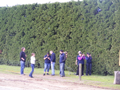
A photograph of volunteers from the Wellington Emergency Management Office taking photographs of the lateral shifting and cracks in a road after the 4 September 2010 earthquake.

Photograph captioned by Fairfax, "Aerial shot of the fault line that ruptured, causing Saturday's 7.1 earthquake. The fault line ripped across a road which has been repaired".

Photograph captioned by Fairfax, "Aerial shot of the fault line that ruptured, causing Saturday's 7.1 earthquake. The fault runs between the house and garage of this property".

Photograph captioned by Fairfax, "Aerial shot of the fault line that ruptured, causing Saturday's 7.1 earthquake. The fault runs between the house and garage of this property".

Photograph captioned by Fairfax, "Aerial shot of the fault line that ruptured, causing Saturday's 7.1 earthquake. The fault runs between the house and garage of this property".

Photograph captioned by Fairfax, "Aerial shot of the fault line that ruptured, causing Saturday's 7.1 earthquake. Locals walk across a paddock showing jagged scars from the fault line".

Photograph captioned by Fairfax, "Aerial shot of the fault line that ruptured, causing Saturday's 7.1 earthquake. Locals walk across a paddock showing jagged scars from the fault line".

Photograph captioned by Fairfax, "Aerial shot of the fault line that ruptured, causing Saturday's 7.1 earthquake. The fault line runs across the paddocks and road and into the distance".

Photograph captioned by Fairfax, "Aerial shot of the fault line that ruptured, causing Saturday's 7.1 earthquake. The fault line runs across the paddocks and road and into the distance".

Photograph captioned by Fairfax, "Aerial shot of the fault line that ruptured causing Saturday's 7.1 earthquake. The fault line went in between the house and garage of this property".

Photograph captioned by Fairfax, "Aerial shot of the fault line that ruptured, causing Saturday's 7.1 earthquake. The fault line runs across the paddocks and road and into the distance".

Photograph captioned by Fairfax, "Aerial shot of the fault line that ruptured, causing Saturday's 7.1 earthquake. The fault runs through the front door and out the back of this property".