
A photograph of damaged land near River Road in Lincoln.

A photograph of damaged land near River Road in Lincoln.

A photograph of damaged land near River Road in Lincoln.

A photograph of damaged land near River Road in Lincoln.

A photograph of damage to the ground of a paddock on the Greendale fault line.

A photograph of damage to the ground of a paddock on the Greendale fault line.

A photograph of damage to the ground of a paddock on the Greendale fault line.

A photograph of damage to the ground of a paddock on the Greendale fault line.

Photograph captioned by Fairfax, "Gerry Brownlee explains the EQC plan to remediate land damaged in the Canterbury earthquake".

Photograph captioned by Fairfax, "Nick Rogers, geotechnical specialist, explains the EQC plan to remediate land damaged in the Canterbury earthquake".
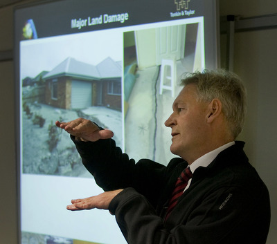
Photograph captioned by Fairfax, "Nick Rogers, geotechnical specialist, explains the EQC plan to remediate land damaged in the Canterbury earthquake".

Photograph captioned by Fairfax, "Nick Rogers, geotechnical specialist, explains the EQC plan to remediate land damaged in the Canterbury earthquake".

Photograph captioned by Fairfax, "Nick Rogers, geotechnical specialist, explains the EQC plan to remediate land damaged in the Canterbury earthquake".

Photograph captioned by Fairfax, "Nick Rogers, geotechnical specialist, explains the EQC plan to remediate land damaged in the Canterbury earthquake".

A large crack where the land has slumped away next to a road. In the background sightseers take photographs of the damage.

A large crack where the land has slumped away next to a road. In the background sightseers take photographs of the damage.

A large crack where the land has slumped away next to a road. In the background sightseers take photographs of the damage.

A large crack where the land has slumped away next to a road. In the background sightseers take photographs of the damage.

A large crack where the land has slumped away next to a road. In the background sightseers take photographs of the damage.

Damage in the car park at Kerrs Reach. A large crack crosses the car park where the land has slumped towards the river.

Photograph captioned by Fairfax, "Gerry Brownlee (left), EQC CEO Ian Simpson, and geotechnical specialist Nick Rogers explain the EQC plan to remediate land damaged in the Canterbury earthquake".

A group of people inspect the damaged rowing club buildings at Kerrs Reach. A large gap has appeared between two concrete slabs beside the building, where the land has slumped towards the river.

Photograph captioned by Fairfax, "Risk revealed: Ten years ago the Northern Outlook printed a front page story about possible damage from a 7.2 magnitude earthquake in the land between the Ashley and Waimakariri rivers".

20100905_3336_1D3-24 Ground movement Pacific Park - Christchurch earthquake
A house in Pacific Park (Bexley) that borders the Bexley Wetlands. Land moved towards the wetlands and the closer to wetlands the more severe the damage.
#382

20100904_3309_1D3-24 Christchurch earthquake
Wairoa Street
Another web site used this image (with a link to this Flickr page), so the view count sky rocketed.
CERA (Canterbury Earthquake Recovery Authority)/Tonkin & Taylor also used this image on page 13 of a Land Damage presentation on 23/06/11. This was also released as a PDF. A few mo...