
Hotel Grand Chancellor, Christchurch.

None

Hotel Grand Chancellor on verge of collapse but still standing after the 6.3 magnitude quake hit Christchurch on 22 February 2011 because of concrete being poured into the lower floors.

A view down Cashel Street from the Bridge of Remembrance, showing earthquake damage to several buildings along Cashel Mall. In the background the Hotel Grand Chancellor can be seen, a Christchurch hotel that was badly damaged in the February 2011 earthquake. The collapse of a key supporting shear wall caused the building to visibly lean to one side.

None

An aerial view of Christchurch a week after the 22 February 2011 earthquake. The Hotel Grand Chancellor can be seen.

An aerial view of Christchurch a week after the 22 February 2011 earthquake. The Hotel Grand Chancellor can be seen.

A photograph of the Hotel Grand Chancellor, visible over the roof of a tent in Latimer Square. There is a noticeable slump in the left side of the hotel.

Aerial image of the Christchurch central city taken by the Royal New Zealand Air Force for the Earthquake Commission. The Hotel Grand Chancellor can be seen.

An aerial photograph the Christchurch Central City. The photograph has been captioned by BeckerFraserPhotos, "The Hotel Grand Chancellor closely surrounded by the Westpac Building and the Holiday Inn".

A photograph of a member of the Wellington Emergency Management Office Emergency Response Team standing in a car park in the Christchurch central city. In the background is the Hotel Grand Chancellor. The hotel has a noticeable slump on the left side.

A photograph of a member of the Wellington Emergency Management Office Emergency Response Team standing in a car park in the Christchurch central city. In the background is the Hotel Grand Chancellor. The hotel has a noticeable slump on the left side.

Damage to the Hotel Grand Chancellor can be seen in the middle. At the bottom left is the lift shaft (now fully demolished) of the CTV building which claimed over 100 lives when it collapsed in the earthquake.
Taken during a scenic flight over Christchurch, New Zealand, 3 months after the deadly earthquake of 22 February, 2011.
Much of the inn...

Hotel Grand Chancellor - Leaning 1m to the east, demolition will start about mid June and is expected to take 10 months to complete at a cost of approx NZ$10m. It will be the biggest & tallest demolition project in New Zealand.
Taken during a scenic flight over Christchurch, New Zealand, 3 months after the deadly earthquake of 22 February, ...

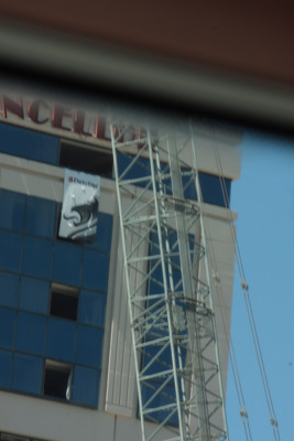
An aerial photograph of the Christchurch central city near Cashel and High Streets. The photograph has been captioned by BeckerFraserPhotos, "The dense collection of buildings surrounding the Hotel Grand Chancellor with the two cranes being used for the demolition. What little of the street is visible running horizontally across the photograph is Hereford Street".

A photograph of traffic barriers on the corner of Colombo and Tuam Street in central Christchurch.

Much of the CBD is still cordoned off and without power (as you should be able to spot) as a result of the damage caused by February's deadly earthquake.
This photo clearly shows the extent of the lean that the Hotel Grand Chancellor is now on. Apparently it is out by 1m at the top leaning east.
Demolition will start about mid June and is expec...

A photograph of traffic barriers on the corner of Colombo and Tuam Street in central Christchurch.

Neighbours across the river showing earthquake damage. Hotel Grand Chancellor in the background.
File reference: CCL-2011-08-12-CanterburyPublic Library pre-demolition-044
From the collection of Christchurch City Libraries.

An aerial photograph of the Christchurch CBD. The photograph has been captioned by BeckerFraserPhotos, "This photograph shows the many tall CBD buildings, with the Hotel Grand Chancellor under demolition in the centre of the photograph. The street in the foreground running up the photograph from left to right is Lichfield Street with the old Bus Exchange clearly visible".
For the first time in November 2011, Christchurch residents finally had the opportunity to see the earthquake-damaged city centre on the Red Zone bus tours organised by CERA. A partial view of the Hotel Grand Chancellor.

An aerial photograph of the Christchurch central city with Colombo Street at the bottom and the Westpac Trust building in the top right.

An aerial photograph of Christ Church Cathedral.

An aerial photograph of the Christchurch Central City. The photograph has been captioned by BeckerFraserPhotos, "Central city blocks bounded by Colombo Street, Hereford Street, Cashel Street and High Street".

Photograph captioned by BeckerFraserPhotos, "Aerial view of the centre of the city, with the cathedral in the centre, and the art gallery in the foreground".

Taken during a scenic flight over Christchurch, New Zealand, 3 months after the deadly earthquake of 22 February, 2011.
Much of the inner city CBD is still cordoned off and will be for some time. About 900 buildings are set for demolition.
Taken aboard the Southern DC3
www.so...

An aerial photograph of the Christchurch city central. The photograph is captioned by BeckerFraserPhotos, "Provincial Council Chambers in the middle, with Brannigans on the lower left, the Central Library lower middle and the Farmers car park on the lower right".

An aerial photograph of the Christchurch central city. The photograph has been captioned by BeckerFraserPhotos, "High Street runs across this photograph in the top third from the old Majestic Theatre at the intersection of Manchester and Lichfield Streets to the intersection of Madras and St Asaph Street which is just beyond the edge of the photo".

An aerial photograph of the Christchurch central city. The photograph has been captioned by BeckerFraserPhotos, "The central city, with the Majestic Theatre in the centre of the photograph. Lichfield Street runs from bottom left diagonally up the photograph to the top right. The City Council building is prominent in the bottom left corner and Latimer Square in the top left corner".

Photographs of central Christchurch after the 2010-2012 earthquakes taken 25 February 2012 by Sean McMahon. Locations are chiefly Manchester, Saint Asaph, Cashel, Columbo and Lichfield Streets, and the Bridge of Remembrance. Images show fencing around areas closed to the public, damaged and collapsed commercial buildings, cleared sites, re-opened Cashel Street area with shops and a cafe.
Source of title - Title supplied by Library
Quantity: 34 digital photograph(s).