None

None

Photograph captioned by BeckerFraserPhotos, "St Andrews Hill Road".

The road at the base of Scarborough Hill. The road goes from Sumner over the hill to Taylor's Mistake.

Photograph captioned by BeckerFraserPhotos, "St Andrews Hill Road".

None

None

A photograph captioned by BeckerFraserPhotos, "Two decorated road cones at 41 Cannon Hill Crescent in Mt Pleasant".

A view of Sumner, including the beach, taken from Richmond Hill Road.

A photograph of an earthquake-damaged wall on St Andrews Hill Road.

A photograph of an earthquake-damaged wall on St Andrews Hill Road.

A view of Sumner, including the beach, taken from Richmond Hill Road.

A photograph captioned by Paul Corliss, "Church, St Andrews Hill Road. Post 22 February earthquake".

A photograph captioned by Paul Corliss, "Church, St Andrews Hill Road. Post 22 February earthquake".

A photograph captioned by Paul Corliss, "Church roof, St Andrews Hill Road. Post 22 February earthquake".

A red-stickered house on Richmond Hill Road in Richmond. The roofing tiles of the building have been dislodged.

A photograph of a damaged house. The photograph is captioned by Paul Corliss, "St Andrews Hill Road, Mount Pleasant".

A photograph of a damaged house. The photograph is captioned by Paul Corliss, "St Andrews Hill Road, Mount Pleasant".

A large pile of liquefaction silt at a dump on Breezes Road. The photographer comments, "Breezes Road and Anzac Drive have recently opened but are now home to a brand new range of hills thanks to mountains of silt that have been collected by the hard working construction guys that have done a sterling job on the road there".

A photograph of a sign painted on a sheet of plywood on St Andrews Hill Road. The sign reads, "Poppy's Party".

Miss Feaver florist on Hills Road
File Ref: CCL-2011-03-17-St Albans-IMG_0390
From the collection of Christchurch City Libraries.

Miss Feaver Florist on Hills Road
File Ref: CCL-2011-03-17-St Albans-IMG_0389
From the collection of Christchurch City Libraries.

Liquefaction surrounds a car on Hendon Street in St Albans, near the corner with Hills Road. In the background, 'keep clear' tape cordons off the front of a property.

Large piles of liquefaction silt at a dump on Breezes Road. One of the piles is covered with black plastic and weighted down with tyres. Trucks and diggers are adding more silt to the piles. The photographer comments, "Breezes Road and Anzac Drive have recently opened but are now home to a brand new range of hills thanks to mountains of silt that have been collected by the hard working construction guys that have done a sterling job on the road there".

Large piles of liquefaction silt at a dump on Breezes Road. One of the piles is covered with black plastic and weighted down with tyres. Trucks and diggers are adding more silt to the piles. The photographer comments, "Breezes Road and Anzac Drive have recently opened but are now home to a brand new range of hills thanks to mountains of silt that have been collected by the hard working construction guys that have done a sterling job on the road there".

Liquefaction silt surrounding a power pole in Ferry Road, next to a cut-out of a smiling and waving David Carter, National MP for the Port Hills electorate.

Liquefaction silt surrounding a power pole in Ferry Road, next to a cut-out of a smiling and waving David Carter, National MP for the Port Hills electorate.

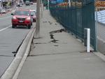
One landscape colour digital photograph taken on 25 February 2011 showing earthquake damage to the road, footpath and retaining wall on Norwich Quay. The photograph is taken from below the intersection of Norwich Quay and Canterbury Street looking east along Norwich Quay. Unlike most areas of Christchurch, land damage on the Port Hills was due ...

A digitally manipulated image of a excavator claw tangled with reinforcing cable, with a damaged concrete building in the background. The photographer comments, "The monster destroying the earthquake broken buildings close to the Lyttelton tunnel".

A view down Manchester Street, looking south. The road is noticably buckled, and rubble from damaged buildings can be seen beyond the cordon fence. The photographer comments, "Today I ... went for a walk along the cordon to the north of Christchurch CBD which runs about one street back from Bealey Avenue. The soldiers manning the cordon seemed happy for me to take photos but I couldn't see much of the city from the barrier ... what you can see shows there's obviously a lot of damage. The roads are swollen and raised in many place. The once flat CBD will now feature plenty of hills as well as natural traffic calming features".
