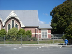
Photo taken outside Opawa Community Church on March 20 following the February 22 earthquake.
File reference: CCL-2011-03-20-After-The-Earthquake-P1110689
From the collection of Christchurch City Libraries

Post February 22 Earthquake Damage
Corner Opawa Road and Aynsley Terrace, Opawa
PWS-2011-03-09-DSC9936

Post February 22 Earthquake Damage
Corner Opawa Road and Aynsley Terrace, Opawa
PWS-2011-03-09-DSC9946

Post February 22 Earthquake Damage
Corner Opawa Road and Aynsley Terrace, Opawa
PWS-2011-03-09-DSC9945

Post February 22 Earthquake Damage
Corner Opawa Road and Aynsley Terrace, Opawa
PWS-2011-03-09-DSC9939

Post February 22 Earthquake Damage
Corner Opawa Road and Aynsley Terrace, Opawa
PWS-2011-03-09-DSC9942

Post February 22 Earthquake Damage
Corner Opawa Road and Aynsley Terrace, Opawa
PWS-2011-03-09-DSC9938

Post February 22 Earthquake Damage
Corner Opawa Road and Aynsley Terrace, Opawa
PWS-2011-03-09-DSC9940

Post February 22 Earthquake Damage
Corner Opawa Road and Aynsley Terrace, Opawa
PWS-2011-03-09-DSC9935

Post February 22 Earthquake Damage
Corner Opawa Road and Aynsley Terrace, Opawa
PWS-2011-03-09-DSC9941

Post February 22 Earthquake Damage
Corner Opawa Road and Aynsley Terrace, Opawa
PWS-2011-03-09-DSC9948

Post February 22 Earthquake Damage
Corner Opawa Road and Aynsley Terrace, Opawa
PWS-2011-03-09-DSC9944

Post February 22 Earthquake Damage
Corner Opawa Road and Aynsley Terrace, Opawa
PWS-2011-03-09-DSC9947

Post February 22 Earthquake Damage
Corner Opawa Road and Aynsley Terrace, Opawa
PWS-2011-03-09-DSC9937

Post February 22 Earthquake Damage
Corner Opawa Road and Aynsley Terrace, Opawa
PWS-2011-03-09-DSC9943

A photograph of a man and a child laying concrete at the site of the Gap Filler Community Chess project.

Shirley Community Centre, Shirley Road, Christchurch.
File reference: CCL-2012-05-10-Around-Shirley-May-2012 DSC_02866.JPG
From the collection of Christchurch City Libraries.

Shirley Community Centre, Shirley Road, Christchurch.
File reference: CCL-2012-05-10-Around-Shirley-May-2012 DSC_02862.JPG
From the collection of Christchurch City Libraries.

Shirley Community Centre, Shirley Road, Christchurch.
File reference: CCL-2012-05-10-Around-Shirley-May-2012 DSC_02869.JPG
From the collection of Christchurch City Libraries.

Shirley Community Centre, Shirley Road, Christchurch.
File reference: CCL-2012-05-10-Around-Shirley-May-2012 DSC_02863.JPG
From the collection of Christchurch City Libraries.

Shirley Community Centre, Shirley Road, Christchurch.
File reference: CCL-2012-05-10-Around-Shirley-May-2012 DSC_02867.JPG
From the collection of Christchurch City Libraries.

A photograph captioned by Paul Corliss, "Heathcote Cricket Club and Community Centre".

A photograph captioned by Paul Corliss, "Heathcote Cricket Club and Community Centre".

A photograph captioned by Paul Corliss, "Heathcote Cricket Club and Community Centre".

A photograph captioned by Paul Corliss, "Heathcote Cricket Club and Community Centre".

A photograph captioned by Paul Corliss, "Heathcote Cricket Club and Community Centre".

A photograph captioned by Paul Corliss, "Linwood library building, Stanmore Road".

A photograph captioned by Paul Corliss, "Heathcote Cricket Club and Community Centre".

A photograph captioned by Paul Corliss, "Heathcote Cricket Club and Community Centre".

A photograph captioned by Paul Corliss, "Heathcote Cricket Club and Community Centre".
