Part of Maffeys Road around McCormacks Bay has collapsed.

Roadworks in progress on the corner of Maffeys and McCormacks Bay Roads. A digger works on a road that is being supported by a retaining wall.

A photograph of Whole House Reuse item 34. This item was salvaged from 19 Admiral Way in New Brighton as part of the Whole House Reuse project.

An aerial photograph of Pegasus Bay near the mouth of the Waimakariri River. To the left, Brooklands can be seen as well as Kairaki in the distance.

A photograph of Whole House Reuse item 33. This item was salvaged from 19 Admiral Way in New Brighton as part of the Whole House Reuse project.

When I was a kid this bit of land in the foreground was level and extended at least three times further out, but after the earthquakes you can see the angle that land near the river slumped. We used to catch a lot of herrings (yellow -eyed mullet) here when I was a kid, hence the local name of Herring Bay. Across the river is the Bexley Wetlands.

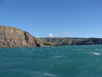
One landscape colour digital photograph taken on 26 May 2013 off Godley Head looking north to Boulder Bay and Taylors Mistake. Rock which fell from the cliffs is heaped at the waters edge. Volcanic banding is visible in the face of the cliffs. There were several major rock falls along the coastal cliffs near Christchurch and Lyttelton Harbour....