
A photograph of the earthquake damage to the back of Wharetiki on Colombo Street. The chimney of the house has pulled away from the back wall and collapsed onto the roof below. A wooden structure built up against the house has also pulled away from the wall.

An aerial photograph of a residential area in New Brighton. The photograph has been captioned by BeckerFraserPhotos, "New Brighton Road, Wattle Drive and Waygreen Avenue. These houses are mostly red zoned with a few green zoned houses in the bottom right".

A photograph of buildings on Armagh Street, taken from behind a cordon. From the front, there is the Provincial Chambers building, the Craig's Investment Partners House, the Victoria Apartments, and the Forsyth Barr building. The PricewaterhouseCoopers building can also be seen to the left.

A photograph of stencilled words on a footpath on Peterborough Street. The words read, "On Peterborough Street the houses are wonky. The ground has been pulled out from underneath them. The trick worked and the houses stayed up, but they are wonky. If you lived in them you might become wonky too".

A damaged house with a red sticker on its front window. The sticker indicates that the building is unsafe to enter. To the side, the brickwork has crumbled and in the front the broken windows have been boarded up. A woman in a florescent vest can be seen to the left, inspecting the house.
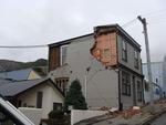
One landscape colour digital photograph taken on 25 February 2011 showing earthquake damage to houses on the western side of Canterbury Street between London and Winchester Streets. The photograph shows large sections of a brick firewall which have fallen onto the roof of the neighbouring house. The close proximity of buildings in Lyttelton led...

20130704_7680_EOS M-22 Another one on the way out!
The Mack tractor unit with "half a house" ready to depart in the middle of the night, when the roads are quiet. But where is this house heading too?
#3900

A page banner promoting an article about insurance issues when buying a house.

A photograph of the badly-damaged House of Travel office on Papanui Road.

The front page graphic for an advertising feature about the new Press House.

A graphic comparing house prices in the east and south-west of Christchurch.

Photograph captioned by Fairfax, "A Clifton Hill house shunted to the cliff edge".

An infographic showing the status of houses in St Martins, Sydenham, and Opawa.

Some flowers in the garden of a house on Galbraith Avenue in Avonside.

A house on Avonside Drive showing large cracks in its foundations and siding.

A photograph of a brick from the demolished house at 116 Centaurus Road.

Damage to a house where the wall has crumbled, exposing the internal structure.

Damage to Wharetiki House. Wooden beams are all that remain of the roof.

Collapsed bricks on a house exposing the inside wall above the door archway.

Collapsed bricks on a house exposing the inside wall above the door archway.

A photograph showing shipping containers stacked to protect one side of MSC house.

A photograph of graffiti by ROAM on a house in Hulverston Drive, Avondale.

A photograph of a brick from a demolished house at 272 Barbadoes Street.

A photograph of the earthquake damage to a house at 18 Percy Street.

A photograph of the basement of a demolished house at 116 Centaurus Road.

A two-storey house where the ground level walls have been boarded up.

Damage to a house in Pines Beach, after the September 4th earthquake.

Detail of damage to Beaufort House on Latimer Square, seen through a fence.

Detail of the deconstruction work on the Pacific Brands House on Victoria Street.

A photograph of a brick from the demolished house at 116 Centaurus Road.