
Photograph captioned by BeckerFraserPhotos, "15 Waygreen Avenue in New Brighton, now red zoned land. The homeowner still lives in this property and is keeping it in immaculate condition".

Large cracks between concrete slabs in a pathway beside the Southern Region Coastguard Waimakariri-Ashley boathouse on Charles Street in Kaiapoi show how the land has slumped towards the river.

A photograph of the former site of Siobhan Murphy's house at 436 Oxford Terrace. Murphy's house was demolished after her land was zoned Red. Grass has grown over the site.
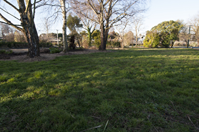
A photograph of the former site of Siobhan Murphy's house at 436 Oxford Terrace. Murphy's house was demolished after her land was zoned Red. Grass has grown over the site.

A photograph of the former site of Siobhan Murphy's house at 436 Oxford Terrace. Murphy's house was demolished after her land was zoned Red. Grass has grown over the site.

A photograph of the former site of Siobhan Murphy's house at 436 Oxford Terrace. Murphy's house was demolished after her land was zoned Red. Grass has grown over the site.

A photograph of the former site of Siobhan Murphy's house at 436 Oxford Terrace. Murphy's house was demolished after her land was zoned Red. Grass has grown over the site.

A photograph a cleared block of land on the corner of Hereford Street and Manchester Street. An excavator can be seen behind a row of shipping containers on the left.

A digitally manipulated image of two chairs sitting among rubble. The photographer comments, "There is a strip of land that has been declared as the red zone. This means that the houses facing towards the tidal estuary must be abandoned as they are on land that has been declared uneconomic to repair after the Christchurch earthquakes. These chairs are at the front of one of these properties that will be bulldozed. These seem to be saying come hell or high water we will not be moved".

A photograph of the former site of a house at 466 Oxford Terrace. The house was demolished after the land was zoned Red. Grass has begun to grow on the site.

A photograph looking north along the footpath of Bangor Street. To the right there are the former sites of several houses. The houses were demolished after the land was zoned Red.

Mounds of liquefaction at an abandoned property on Waireka Lane, Bexley.

Over-grown weeds at an abandoned section on Waireka Lane, Bexley.

Two skeletal people sit in armchairs waist-deep in silt. The man is reading the newspaper and says 'The wait's over! The Land Report's due out dear!... DEAR?' He realises that his wife, whose bony hand clutches 'EQC update No. 37', is dead. Context - On Thursday 23 June Prime Minister John Key, Canterbury Earthquake Recovery Minister Gerry Brownlee and representatives from engineering consultants Tonkin & Taylor announced the first part of the Government's long-awaited land report that revealed the fate of up to 5000 quake-damaged homes.
Quantity: 1 digital cartoon(s).

A photograph of the former site of Doug Sexton's house at 378 Oxford Terrace. Sexton's house was demolished after his land was zoned Red. Grass has begun to grow in the site.

A photograph of the former site of Robin Duff's house at 386 Oxford Terrace. Duff's house was demolished after his land was zoned Red. Grass has begun to grow on the site.

A photograph of the former site of a house at 58 Bangor Street. The house was demolished after the land was zoned Red. The grass has begun to grow over the site.

A photograph of the former site of the Locke family's house at 392 Oxford Terrace. The Locke's house was deconstructed after their land was zoned Red. Grass has grown over the site.

A photograph of the former site of Doug Sexton's house at 378 Oxford Terrace. Sexton's house was demolished after his land was zoned Red. Grass has begun to grow in the site.

A photograph of the former site of Doug Sexton's house at 378 Oxford Terrace. Sexton's house was demolished after his land was zoned Red. Grass has begun to grow in the site.

A photograph of the former site of Robin Duff's house at 386 Oxford Terrace. Duff's house was demolished after his land was zoned Red. Grass has begun to grow on the site.

Being prepared for removal. Is in red zone so has to go.d
The house had minimal damage, but the land it was on was deemed to be no good - red zoned.

Photograph captioned by BeckerFraserPhotos, "37 Cannon Hill Crescent in Mt Pleasant. Most of Mt Pleasant is green zoned, but 800 homes will be demolished".

Photograph captioned by BeckerFraserPhotos, "The empty site where 31 Cannon Hill Crescent in Mt Pleasant used to be".

Liquefaction covers the driveway of these residential properties on Seabreeze Close, Bexley.
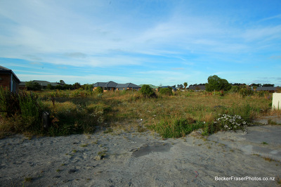
Liquefaction is still evident at this abandoned residential section on Seabreeze Close, Bexley.

A photograph of the former site of the house at 466 Oxford Terrace. The house was demolished after the land was zoned Red. Wire fencing has been placed in front of the site.

Boarded-up broken windows on the old Christchurch City Council building in Tuam Street. The photographer comments, "What can happen to a building when the land is no longer solid as a rock".

A vehicle drives onto the damaged Dallington bridge. The land has slumped relative to the bridge, leaving the approach road at a steep incline. The photographer comments, "Dallington Bridge northern approach, Gayhurst Rd".

A group of people inspect the damaged rowing club buildings at Kerrs Reach. A large gap has appeared between two concrete slabs beside the building, where the land has slumped towards the river.