
Photograph captioned by Fairfax, "Aerial shot of the fault line that ruptured, causing Saturday's 7.1 earthquake. Hororata Homestead totalled by the quake".
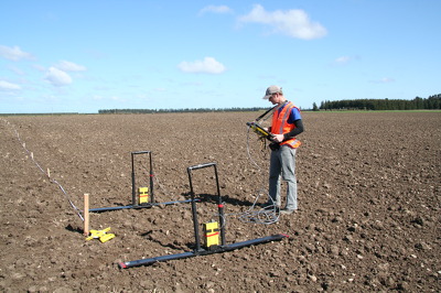
A photograph of University of Canterbury Geology student Matt Cockcroft using ground penetrating radar (GPR) to survey land on the Greendale fault line.

Photograph captioned by Fairfax, "Aerial shot of the fault line that ruptured causing Saturday's 7.1 earthquake. A deer fenceline destroyed by the quake".

Photograph captioned by Fairfax, "Aerial shot of the fault line that ruptured, causing Saturday's 7.1 earthquake. Track, fence and hedge showing horizontal displacement".

A photograph of University of Canterbury Geology students Zach Whitman and Dewiyani Bealing using ground penetrating radar equipment to survey land on the Greendale fault line.

Photograph captioned by Fairfax, "Visiting professor Kevin Furlong from Penn State University in the USA looks at the fault line west of Burnham after Saturday's earthquake".

Photograph captioned by Fairfax, "Visiting professor Kevin Furlong from Penn State University in the USA looks at the fault line west of Burnham after Saturday's earthquake".
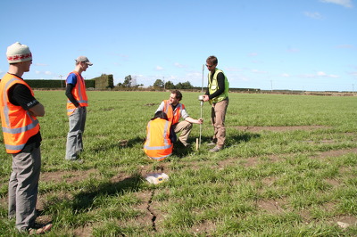
A photograph of University of Canterbury Geology staff and students using a dynamic cone penetrometer to measure soil strength of a paddock on the Greendale fault line.

A photograph of a sign in Sophie's Café on Papanui Road. The first line of the sign reads, "Yes toilet is outside and yes its not our fault".

Photograph captioned by Fairfax, "Pilar Villamor, an earthquake scientist with GNS, near the end of the earthquake fault, which has caused a dip in this paddock, leading to flooding".

A photograph of University of Canterbury Geology students using ground penetrating radar equipment to survey land on the Greendale fault line. From left: Matt Cockcroft, Zach Whitman and Dewiyani Bealing.

A photograph of University of Canterbury Geology students using ground penetrating radar equipment to survey land on the Greendale fault line. From left: Matt Cockcroft, Zach Whitman and Dewiyani Bealing.

A photograph of University of Canterbury Geology students using ground penetrating radar equipment to survey land on the Greendale fault line. From left: Matt Cockcroft, Zach Whitman and Dewiyani Bealing.

A photograph of University of Canterbury Geology staff and students using ground penetrating radar (GPR) to survey land on the Greendale fault line. From left: Thomas Wilson, Zach Whitman and Matt Cockcroft.

Text at top left reads 'Daft things our forefathers did The cartoon shows several nineteenth century gentlemen observing 'volcanic cones', a 'swamp' and 'faultlines underneath' and deciding to build a city. Context - Specifically the Christchurch earthquakes of 4 September 2010 and 22 February 2011 but generally the way many New Zealand cities are built on or near volcanoes, faultlines and swamps.
Quantity: 1 digital cartoon(s).

Ground heaving on the faultline from which the Saturday 4 September 2010 earthquake originated.

The ground literally opened up! On the previously unknown faultline along which the Saturday 4 September 2010 earthquake originated.

The ground literally opened up! On the previously unknown faultline along which the Saturday 4 September 2010 earthquake originated.

The ground literally opened up! On the previously unknown faultline along which the Saturday 4 September 2010 earthquake originated.

The ground literally opened up! On the previously unknown faultline along which the Saturday 4 September 2010 earthquake originated.

If you look very closely, running from the nearest right desk to the second desk on the left hand side, you can see my 'fault-line', - the crack that runs the length of the classroom under the lino.

Photograph captioned by Fairfax, "Maarten Schaap with his campervan which he and his family live in after their house was damaged in the quake, he lives at the end of the fault line where all the aftershocks are located".

Photograph captioned by Fairfax, "New Zealand's Governor-General Anand Satyanand and his wife Susan Satyanand visited sites around earthquake-stricken Canterbury today. Satyanand at the epicentre near Darfield where the new fault line can be clearly seen across a rural paddock".

Photograph captioned by Fairfax, "New Zealand's Governor-General Anand Satyanand and his wife Susan Satyanand visited sites around earthquake stricken Canterbury today. Satyanand at the epicentre near Darfield where the new fault line can be clearly seen across a rural paddock".

Photograph captioned by Fairfax, "New Zealand's Governor-General Anand Satyanand and his wife Susan Satyanand visited sites around earthquake stricken Canterbury today. Satyanand at the epicentre near Darfield where the new fault line can be clearly seen across a rural paddock".

Photograph captioned by Fairfax, "New Zealand's Governor-General Anand Satyanand and his wife Susan Satyanand visited sites around earthquake stricken Canterbury today. Satyanand at the epicentre near Darfield where the new fault line can be clearly seen across a rural paddock".

Toppled grain silos on the outskirts of Darfield near the epicentre of the magnitude 7,1 earthquake that struck on Saturday 4 September 2010.

Toppled grain silos on the outskirts of Darfield near the epicentre of the magnitude 7,1 earthquake that struck on Saturday 4 September 2010.

Toppled grain silos on the outskirts of Darfield near the epicentre of the magnitude 7,1 earthquake that struck on Saturday 4 September 2010.

Heaving and subsidence on the faultline left scars where the magnitude 7.1 earthquake on Saturday 4 September 2010 originated.