
One landscape colour digital photograph taken on 15 June 2011 showing earthquake damage to the Anglican Church of The Most Holy Trinity in Winchester Street, Lyttelton. Photograph shows collapsed roof of the nave and north transept. Photograph taken from the north side of the church. Architect The collapse of the Church of the Most Holy Trinity ...
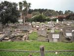
One landscape colour digital photograph taken on 30 June 2011 showing earthquake damage to graves in Lyttelton Roman Catholic and Dissenters (Public) Cemeteries in Reserve Terrace. Most of the headstones and grave surrounds in the photograph show damage. Looking east in the Dissenters (Public) section of the cemetery. The Lyttelton cemeteries a...

One landscape colour digital photograph taken on 30 June 2011 showing earthquake damage to a section of retaining wall in Sumner Road. Plastic sheeting installed to stabilise previous damage and protect from water erosion is visible to the right of the photograph. Also visible in the photograph is a boarded up broken window and temporary safety ...

One landscape colour digital photograph taken on 15 June 2011 showing earthquake damage to the Anglican Church of The Most Holy Trinity in Winchester Street, Lyttelton. Photograph shows collapsed roof of the nave and north transept. Photograph taken from the northwest corner of the church. Architect The collapse of the Church of the Most Holy Tr...

One silver medal awarded to SCIRT in October 2013 from the Institution of Civil Engineers in the United Kingdom in recognition of the excellent in civil engineering. Includes storage case and explanation sheet.

NZi3 building reopens after the September earthquakes.

NZi3 building reopens after the September earthquakes.

NZi3 building reopens after the September earthquakes.

NZi3 building reopens after the September earthquakes.

NZi3 building reopens after the September earthquakes.

NZi3 building reopens after the September earthquakes.

NZi3 building reopens after the September earthquakes.

One metal hanging light fixture with three globes. Frame features a stylized plants motif. The globes feature green, brown and white glass petals welded into a globe shape. Owner of Hadleigh House 1904-1921
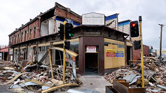
Aftermath of September 4th Earthquake in Canterbury. Shops on Colombo Street in Christchurch - damaged in earthquake and then partially demolished to reduce risk from unstable materials which might otherwise be dislodged in strong winds or subsequent aftershocks. The 1590 aftershocks recorded to date have continued to cause further damage.

Cracks on the road in Avonside after the September 4th earthquake.

Liquefaction in the drains in Avonside after the September 4th earthquake.

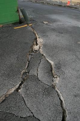
Cracks across the road in Avonside after the September 4th earthquake.
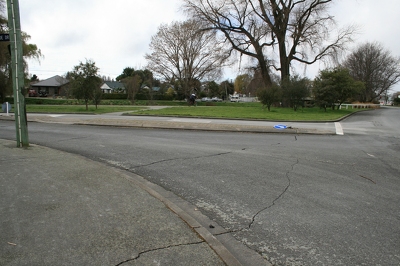
Cracks across the road in Avonside after the September 4th earthquake.
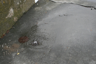
Water surging out of a drain after the September 4th earthquake.

A lopsided powerline pole in Avonside after the September 4th earthquake.

Cracks along the ground in Kaiapoi, after the September 4th earthquake.
Cracks in a road in Kaiapoi, after the September 4th earthquake.

One landscape colour digital photograph taken on 6 September 2010 showing liquefaction in Hagley Park. Liquefaction is the name of the process where water pushes sand and silt above ground. These puddles of sand and silt are left above ground. Liquefaction caused huge problems when it occurred in residential suburbs as was as likely to push thr...

One landscape colour digital photograph taken on 16 June 2011 showing the eastern skyline of Lyttelton without the tower of the Timeball Station and Signal Mast. Part of the ground floor remains visible. The Holcim Cement Silos and Lyttelton Port of Christchurch log storage yard are visible in the foreground. Photograph taken from Oxford Street...

One landscape colour digital photograph taken on 19 November 2011 showing the alleyway next to 29 London Street. These steps provided access to the Wunderbar and the Monsta Bar (closed). Visible to the left is the Lyttelton Coffee Company building being repaired. Prior earthquake strengthening enabled the Lyttelton Coffee Company to undertake w...

One landscape colour digital photograph taken on 19 November 2011 showing part of the north side of London Street. The properties visible from left to right are Lyttel Piko Organic and Wholefoods, and Satchmo Café Pizzabar The Lyttelton streetscape has changed dramatically from its pre-earthquake appearance and will continue to change as new bu...

One portrait colour digital photograph taken on 19 November 2011 showing a poster advertising the planned 2011 Census which was scheduled for Tuesday 8 March 2011. The census was abandoned because of the 22 February 2011 Earthquake. The poster was located in the window of the Lyttelton Information Centre on Oxford Street. The building was closed...

One portrait colour digital photograph taken on 19 November 2011 showing the framework of the Lyttelton Coffee Company Building surrounded by safety fencing. On the fencing are election hoardings and an advertisement for Samo, the café established by employees of the Lyttelton Coffee Company. Prior earthquake strengthening enabled the Lyttelton...

One landscape colour digital photograph taken on 26 May 2013 showing the southern cliffs of Godley Head, taken from the middle of the shipping channel. Some earthquake damage to the cliffs is visible. There were several major rock falls along the coastal cliffs near Christchurch and Lyttelton Harbour. At Godley Head these caused damage to the ...

One landscape colour digital photograph taken on 27 May 2013 of London Street in Lyttelton. Taken from Sumner Road looking west across the intersection of London and Oxford Streets. The photograph shows several empty sections and the remaining buildings. The Lyttelton streetscape has changed dramatically from its pre-earthquake appearance and w...