
A front page layout for the Nelson Mail, marking the anniversary of the 22 February 2011 earthquake.

An infographic showing the fault ruptures which caused the 4 September 2010 and 22 February 2011 earthquakes.

A graph showing the decline in international student numbers in Canterbury following the 22 February 2011 earthquake.

A front page graphic for the Christchurch Mail, marking the anniversary of the 22 February 2011 earthquake.

An infographic showing the teams for the first Crusaders home game since the 22 February 2011 earthquake.

A compliation of aerial photographs of Christchurch and Lyttelton showing damage caused by the 22 February 2011 earthquake.

A compliation of aerial photographs of Christchurch and Lyttelton showing damage caused by the 22 February 2011 earthquake.

A compliation of aerial photographs of Christchurch and Lyttelton showing damage caused by the 22 February 2011 earthquake.

A map showing the extent of liquefaction caused by the 4 September 2010 and 22 February 2011 earthquakes.

West side of Colombo Street looking south-ish, taken from near the corner of Armagh Street.

Photograph captioned by Fairfax, "Damage from the February 22nd earthquake in Christchurch. House in Redcliffs".

One right front black Mazda CX7 car door damaged during the 22 February 2011 earthquake. This panel once belonged to a Mazda CX7 car that was crushed by falling rubble during the 22 February 2011 earthquake. Considerably bent out of shape, it demonstrates the potential danger from falling masonry during an earthquake. The spray painted markings...

One landscape colour digital photograph taken on 25 February 2011 showing earthquake damage to the Catholic Church of St Joseph the Worker in Winchester Street Lyttelton. Photograph shows the eastern side of the church. Photograph taken from St Davids Street. The earthquake damaged eastern wall of the Catholic Church of St Joseph the Worker sho...

One landscape colour digital photograph taken on 25 February 2011 showing Her Majesty's New Zealand Ships (HMNZS) (left to right) Pukaki, Otago and Canterbury berthed at Number Seven Wharf in Lyttelton's Inner Harbour. HMNZS Canterbury was tied up in Lyttelton loading New Zealand Army equipment when the magnitude 6.3 earthquake occurred on 22 F...

Photograph captioned by Fairfax, "Damage from the February 22nd earthquake in Christchurch. The Provincial Buildings".

Photograph captioned by Fairfax, "Damage from the February 22nd earthquake in Christchurch. The PGC building".

Photograph captioned by Fairfax, "Damage from the February 22nd earthquake in Christchurch. The Provincial Buildings".

Photograph captioned by Fairfax, "Damage from the February 22nd earthquake in Christchurch. Grand Chancellor slumped".

An aerial view of Christchurch a week after the 22 February 2011 earthquake. Manchester and Gloucester Streets can be seen.

An aerial view of Christchurch a week after the 22 February 2011 earthquake. The Hotel Grand Chancellor can be seen.

Medics from the New Zealand army preparing to evacuate Christchurch rest home residents affect by the 22 February 2011 earthquake.

An aerial view of Christchurch a week after the 22 February 2011 earthquake. The Hotel Grand Chancellor can be seen.

A member of No. 3 Squadron in the Iroquois helicopter making tours of Christchurch after the 22 February 2011 earthquake.

A member of No. 3 Squadron in the Iroquois helicopter making tours of Christchurch after the 22 February 2011 earthquake.

An infographic identifying students from the Toyama College of Foreign Languages who died in the 22 February 2011 earthquake.

Armagh Street, near the corner of Durham Street North, looking east-ish towards the Canterbury Provincial Council and Supreme Court Buildings.

Royal New Zealand Air Force Iroquois helicopters flying over the PGC Building after the 22 February 2011 earthquake.
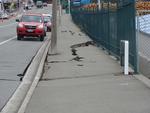
One landscape colour digital photograph taken on 25 February 2011 showing earthquake damage to the road, footpath and retaining wall on Norwich Quay. The photograph is taken from below the intersection of Norwich Quay and Canterbury Street looking east along Norwich Quay. Unlike most areas of Christchurch, land damage on the Port Hills was due ...

One landscape colour digital photograph taken on 25 February 2011 showing a New Zealand Army Light Operational Vehicle on the corner of Norwich Quay and Dublin Street. Light Armoured Vehicles and Light Operational Vehicles were a common sight around Lyttelton and Christchurch after the February 2011 earthquakes. The quakes occurred just before ...
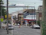
One landscape colour digital photograph taken on 25 February 2011 showing earthquake damage on western side of Oxford Street, Lyttelton Taken from the footpath looking downhill from Lyttelton Main School. The buildings visible (from the foreground) are: London Street Restaurant; Bells Pharmacy; Maritime House (McKay - ISS Limited, Shipping Ag...